
Past Long Term Plans
Discover how Singapore's past long-term plans have guided growth and shaped the city over time.
Last updated 19 May 2026
Concept Plan 1971
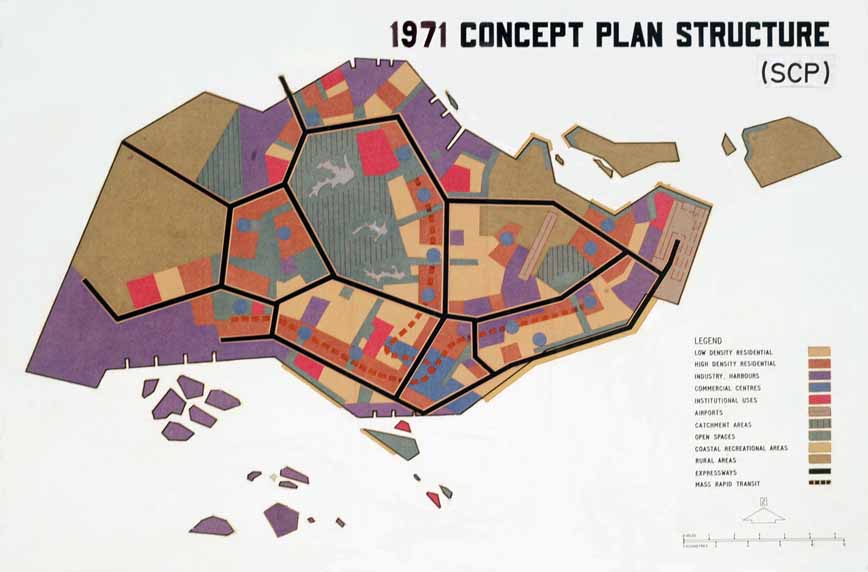
The Concept Plan 1971 laid the foundation for Singapore’s growth and city structure, to meet the basic infrastructure needs of a young nation.
The plan set out broad principles to develop new housing towns, industrial estates, transport infrastructure and recreational spaces across the island, by adopting a ‘ring’ structure of satellite towns around the central water catchment.
The Central Area was established as the Central Business District, and has grown to have many global financial institutions and regional headquarters located here today.
Concept Plan 1991
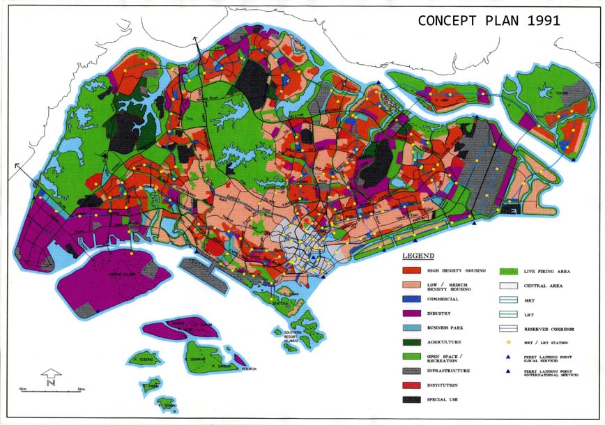
The Concept Plan was reviewed in 1991, where the vision for Singapore evolved from meeting basic needs to creating an island city balancing work and play, culture and commerce, and where nature, waterbodies and urban development are woven seamlessly together.
The Plan proposed cultural and commercial corridors, and a hierarchy of commercial centres in different parts of the island to bring jobs closer to homes and alleviate congestion in the city centre.
Technological corridors, made up of business parks, science parks and academic institutions, were created to facilitate the growth of high-tech industries and to promote the exchange of ideas and innovation.
To support the development of a petrochemical industry, the Plan also proposed for seven low-lying southern islands to be amalgamated into one large island – known as Jurong Island today.
Concept Plan 2001
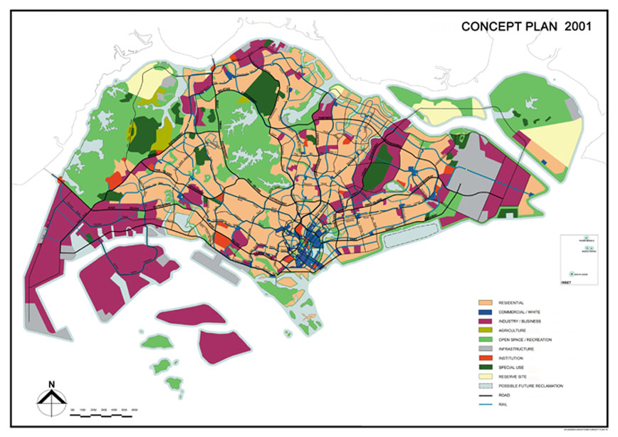
The Concept Plan Review in 2001 factored in new trends to ensure that the land use plans remained robust in addressing future challenges.
The plan envisioned Singapore as a thriving world-class city in the 21st century, with rich heritage, character, diversity and identity. In developing the plan, an extensive public consultation exercise was carried out to seek the views of key stakeholders. It aimed to provide a high quality living environment by offering a wider choice of housing options, and also sought to transform Singapore into a global financial hub by setting aside land in the city centre to support the growth of financial and services sectors.
As part of the Concept Plan 2001, an Identity Plan and Parks and Waterbodies Plan was drawn up to enhance Singapore’s natural and built identity. Under these two plans, we identified 15 nodes where the existing character of the built environment would be reinforced, and created more recreation choices through the opening up of more parks, reservoirs and natural areas.
Concept Plan 2011
This Concept Plan review was carried out in 2011-2013, leading to the release of the Land Use Plan by the Ministry of National Development.
The plan supports the population projected by the National Population & Talent Division for 2030 and outlined the strategies to support population and economic growth, while ensuring a high quality living environment for all Singaporeans.
The Land Use Plan outlines strategies to support population and economic growth, while continuing to ensure a high quality living environment by 2030. The Land Use Plan also sets aside land to meet national needs beyond 2030, so that future generations have options and room for future growth.
The strategies to sustain a high-quality living environment include:
Providing good affordable homes with a full range of amenities
Integrating greenery into the living environment
Providing greater mobility with enhanced transport connectivity
Sustaining a vibrant economy with good jobs
Ensuring room for growth and a good living environment in future
The broad strategies and proposals set out in the Land Use Plan were translated into detailed plans in the Master Plan 2014, which is used to guide our development over the next 10 to 15 years.