
Downtown Core
The Downtown Core Planning Area is the economic and cultural heart of Singapore. The prime office space, supported by a wide range of complementary uses and a live-in population, will contribute to a vibrant mixed-use district.
Last updated 22 June 2026
These urban design guidelines aim to guide the physical development of the area to ensure that individual buildings contribute to, and strengthen the planning vision for the respective zones and create an attractive and pedestrian-friendly physical environment.
Innovative designs that do not fully conform to the guidelines or standard building typologies but are able to achieve the planning objective relevant to the requirement can be considered, subject to URA’s evaluation of the detailed proposal.
Gazetted monuments and conserved buildings are subject to specific preservation and conservation guidelines respectively, which will take precedence over the guidelines below.
Broad Positioning & Land Use
The following section is to be read together with the following plans:
Central Business District (CBD)
The CBD is Singapore’s global and financial district, and home to leading international businesses and financial institutions. It spans from Raffles Place along Shenton Way / Robinson Road / Cecil Street to the Tanjong Pagar and Anson subzones. It also extends to Marina Bay, including the Central and Bayfront subzones.
As part of its continued growth and evolution as a dynamic global hub, the CBD is moving away from a predominantly office district into a vibrant, mixed-use district so that the CBD will not only be a place to work, but also to live and play in.
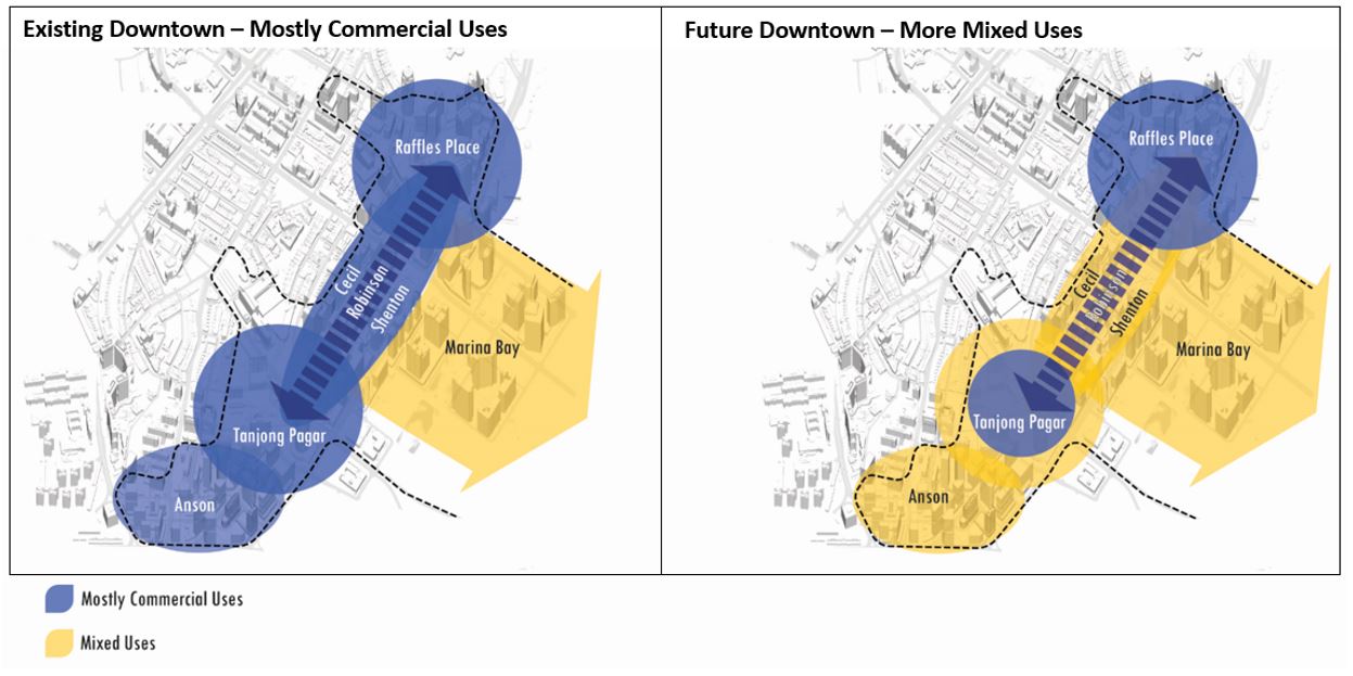
Within Raffles Place and Tanjong Pagar subzones, and along Robinson Road, some complementary uses (e.g. hotel, serviced apartment and residential) can be considered, while retaining the predominantly commercial character of these core areas of our CBD.
Within the Anson and Cecil subzones, a greater mix of residential, serviced apartment, hotel and other uses are encouraged to create more mixed-use urban neighbourhoods. Detailed guidelines for Anson and Cecil subzones are found in Annex A.
In selected areas where mixed-use neighbourhoods are encouraged, existing older office developments that redevelop into mixed-use developments may be considered for increase in development intensity under the CBD Incentive Scheme 2.0.
The sites in the Central and Bayfront subzones are zoned for White use to allow for greater planning flexibility and to encourage a mix of complementary uses – commercial, residential, hotel and entertainment. Developments within the Central subzone may be required to provide a minimum quantum of Office use to realise the planning intention for a business and financial precinct. Developments within the Bayfront subzone are guided to be more mixed-use, with a greater emphasis on the inclusion of hotel, meetings, incentives, conventions and exhibitions (MICE) facilities, entertainment, and retail uses.
City Hall
The City Hall subzone is within the Civic District and is home to a number of historic National Monuments and historic buildings such as the Old Parliament House, the former Supreme Court and City Hall buildings fronting the Padang. It is a mixed-use zone with established Civic and Community Institution (C&CI) uses, such as the Asian Civilisations Museum, Victoria Theatre and Concert Hall and the National Gallery Singapore. The remaining area is zoned for a mix of Commercial and Hotel uses. Notable developments include Raffles City and Raffles Hotel.
Bugis
The Bugis subzone comprises a mix of commercial and hotel developments together with the low-rise shophouses within the Beach Road Conservation Area. It is also home to the National Library and Raffles Hospital. Detailed street block for Beach Road, Tan Quee Lan Street, North Bridge Road and Seah Street can be found in URA/CUD Plan Release 1/2025E.
Marina Centre
The Marina Centre subzone is zoned predominantly for Commercial, Hotel and C&CI uses. It includes a critical mass of exhibition and convention, hotel, and entertainment facilities. A wider mix of uses, including residential /serviced apartment uses is encouraged to create a more vibrant mixed-use precinct.
Nicoll
The Nicoll subzone is positioned as the northern gateway into the city and will feature one of the three gardens at Gardens by the Bay, Bay Central Garden, along the waterfront.
Innovative projects of high quality that do not fully conform to the prevailing guidelines and planning parameters can be considered under the Strategic Development Incentive (SDI) Scheme.
Building Form & Massing
The following section is to be read together with the following plans:
Specific building typology guidelines for Anson and Cecil subzones are found in Annex A [PDF, 570.83 KB].
The overall building form and massing of individual buildings is to consider the scale, form and architectural expression of the surrounding buildings, and be designed to contribute positively to the skyline profile of the city. The design of the building form and massing, together with the architectural treatment, is to consider how the building will be viewed as well as impact views from major approaches, key open spaces, and pedestrian malls.
For developments with building form requirements, alternative configurations of the greenery provisions can be considered, subject to relevant agencies’ approval.
Building Height
Different building heights are specified for individual precincts to create a layered, three-dimensional skyline profile, to respond to the specific site context and to reinforce the character of the district. In general, lower-rise heights are specified where there is a need to maintain a pedestrian-friendly scale, for example, along the waterfront areas, adjacent to low-rise conservation areas, and to safeguard views towards key open spaces.
The maximum allowable building height is subject to the prevailing Master Plan controls as well as the technical height controls imposed by the relevant technical agencies. Urban design height controls will take precedence over technical height controls, if the former is lower.
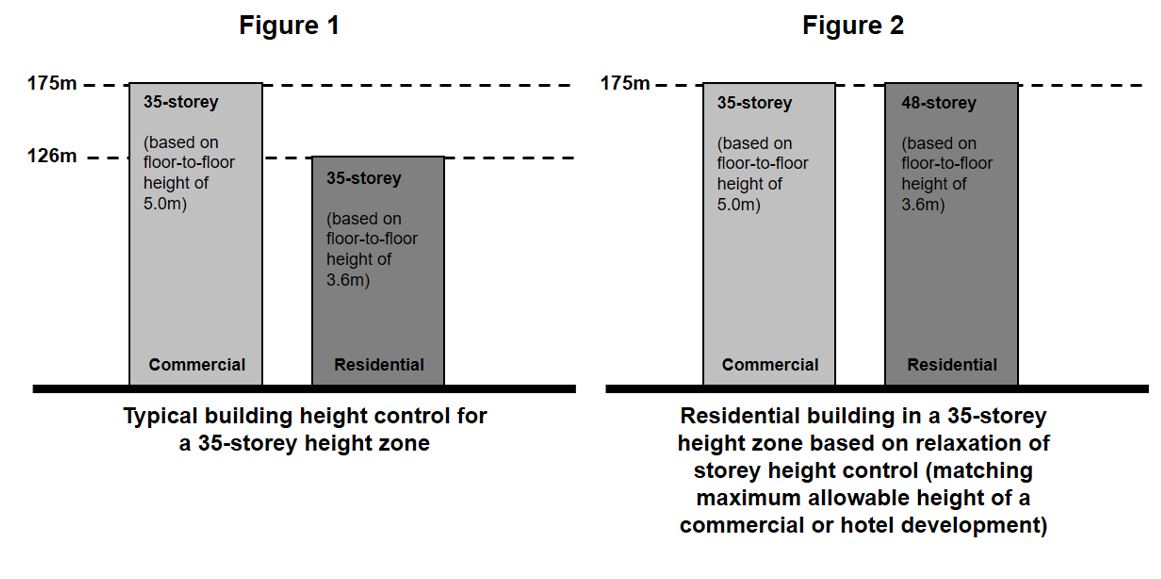
Residential Developments
For residential developments within areas where the relaxation of residential buildings heights apply, an equivalent building height to the maximum allowable height for a commercial building can be considered to give greater design flexibility (see Figure 1 and Figure 2). Notwithstanding this, the current development controls on maximum floor-to-floor heights for residential buildings will continue to apply.
Please note that the height relaxation is not applicable to the following:
Developments within Conservation Areas;
Developments within Special Detailed Control Areas, including those guided by street block plans, envelope controls, areas with particular urban design guidelines for building height; and
Developments within height control of 6 storeys or less.
Building Setback & Building Edge
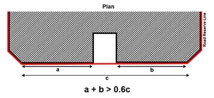
To create distinctive and well-defined streets, all developments are generally to be built-up fully to the lines of Road Reserve to a minimum height of 19.0m (approximately 4 storeys) unless otherwise specified. Up to 40% per building frontage, between the corners of the development, can be set back from the lines of Road Reserve / building setback lines if applicable, for articulation of the building form.
Developments along major boulevards are required to be set back from the lines of the Road Reserve to allow for a wide pedestrian walkway and the planting of an additional row of trees to create a tree-lined boulevard character. This refers to building frontages annotated as “Pedestrian Malls / Promenade / Plaza” in the 1st storey pedestrian network and AGU plan.
For developments fronting the Raffles Place Park, the building edge is to be capped at a maximum height of 30.0m (approximately 6 storeys) to be in keeping with the existing character and scale of the park. The rest of the building, which exceeds 30.0m in height, would have to be set back 6.0m from the site boundary fronting the Park.
Party Wall Developments
Party walled developments are required to abut the common boundary with the adjacent sites to a minimum height of 19.0m (approximately 4 storeys) and up to a maximum height of 100.0m from the street level, or as specified for specific districts. Depending on the site context (e.g. adjacency to residential developments etc), the maximum height of the party wall might be pegged to a lower height, say to match that of the neighbouring development. For developments fronting the Raffles Place Park, the allowable party wall height along the common boundary shall also correspondingly match that of the building edge.
Window openings and facade articulation are not permitted along the party wall. Above the party wall, developments are to be set back by a minimum of 3.0m from the common boundary. Similarly, any M&E services located above the party wall are to be set back by a minimum of 3.0m from the common boundary.
Roofscape
The roof areas of both the high-rise and low-rise parts of developments are to be considered as the “fifth” elevations and designed to complement the overall form, massing and architectural treatment of each development and articulated to contribute to the skyline profile. The roof can be designed to be usable outdoor spaces.
All service areas, car parks, mechanical and electrical (M&E) equipment, water tanks, etc., are to be fully integrated within the overall building envelope and visually well-screened from the top and on all sides.
For more information, please refer to Screening of Mechanical and Electrical Services and Car Parks and Guidelines to Encourage More Innovative and Better Design of Rooftop (Part A. Relaxation of the Gross Floor Area (GFA) Exemption Guidelines for Rooftop Covers)
Greenery Replacement & Landscaping
To create a green and sustainable city, all new developments will be required to incorporate landscaping in the form of sky terraces and roof gardens according to the Landscape Replacement Area (LRA) requirements.
For more information, please refer to the Development Control Handbook.
Connectivity & Active Uses
The following section is to be read together with the following plans:
The Downtown Core Planning Area is planned as a pedestrian-friendly area with a comprehensive pedestrian network at the 1st storey, basement and 2nd storey levels. This network provides convenient, comfortable, and seamless connections between developments, transport facilities, and key spaces and attractions, and ensures all-weather comfort for pedestrians.
The pedestrian network on all levels is to be designed for universal access. GFA exemption can be considered for public spaces, covered walkways, through-block links and elevated walkways, subject to the prevailing Development Control Guidelines.
Covered Walkways
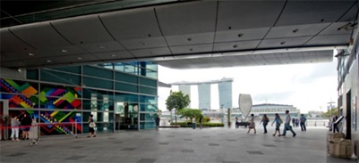
All developments are required to provide covered walkways at the 1st storey along the site boundaries or the designated building setback lines. The covered walkways function as public amenities. They are to be kept free of obstruction at all times.
The platform level of the open and covered walkways is to correspond with the adjacent road as far as possible. For open walkways that are below the minimum platform level, the covered walkways may be allowed below the minimum platform level so that they match the platform level of the open walkways. Any difference in levels between the internal platform level of the 1st storey and the covered walkway are to be mediated within the 1st storey of the development and not along the open walkways / covered walkways/linkways.
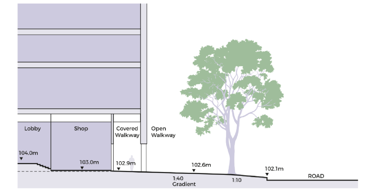
Open walkways below the Minimum Platform Level
The minimum widths of the covered walkways are either 3.0m, 3.6m or 5.0m, depending on the category of road they front onto. Where colonnades are provided, the internal clear widths of the covered walkways are to be 2.4m, 3.0m and 4.4m respectively. To provide adequate protection for pedestrians during inclement weather, the external soffit heights are to minimally match the width of the covered walkway.
To achieve a distinct character within the Civic District, the covered and open walkways along identified streets show in Appendix 7 are to be paved in predominantly 600mm x 600mm flamed finish heavy duty Rossa Porrino (or equivalent) granite tiles, set out perpendicular to the lines of Road Reserve. The remaining walkways are to be paved in predominantly 600mm x 600mm flamed finish heavy duty grey-green granite tiles, set out perpendicular to the lines of Road Reserve.
To maintain the district character within the Downtown Core, covered walkways and open walkways in areas outside the Civic District are to be predominantly paved in 600mm x 600mm flamed finish heavy duty grey-green granite tiles, set out perpendicular to the lines of Road Reserve.
Through-Block Links & View Corridors
Selected developments are required to provide through-block links and/or view corridors to improve the physical and visual permeability of the street block. Through-block links complement the at-grade pedestrian network by allowing pedestrian circulation through long street blocks. View corridors also safeguard key views through the development.
Through-block links are required to have a minimum clear width of 4.0 to 7.0m and a minimum clear height of 10.0m, unless otherwise specified.
Through block link at One Fullerton
Underground Pedestrian Network (UPN)
The UPN complements the 1st storey pedestrian network and provides direct connection to Rapid Transit System (RTS) Stations. The UPNs are to be at least 6.0m wide (with AGUs on one side) or 7.0m (with AGUs on both sides) with a minimum 4.0m (clear) internal ceiling height, unless otherwise specified.
UPNs are to include vertical pedestrian circulation points within the building envelope to connect to the covered walkway at the 1st storey. Each vertical circulation point is to include a pair of two-way escalators, staircases and two passenger lifts.
The entire UPN and the associated vertical circulation points are to be kept open for public access during the opening hours of the RTS.

Marina Bay Link Mall: 7.0m wide UPL with AGUs on both sides
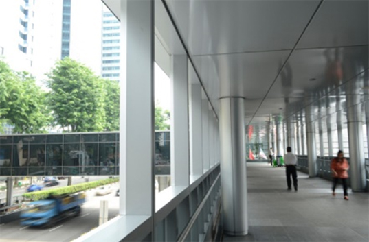
Elevated Pedestrian Network (EPN)
EPN are planned in high density areas with high foot traffic to complement the at-grade pedestrian network and to provide seamless connectivity between developments. The network comprises walkways along the 2nd storey of developments and lightweight link-bridges that span public roads between the 2nd storey walkways. The minimum width of EPN is 4.0m, unless otherwise specified.
EPN are to include vertical pedestrian circulation points (comprising a pair of two-way escalators and two passenger lifts) within the building envelope to link to the covered walkways at the 1st storey. The entire EPN and the associated vertical circulation points are to remain open for public use at all times.
Elevated Pedestrian Link at OUE Bayfront
Uses at the Basement, 1st & 2nd Storey Levels
To create vibrant precincts, attractive and pedestrian-friendly streets, Activity-Generating Uses (AGU), such as retail, food and beverage (F&B), and other active uses are to be provided at the following locations:
The 1st storey of developments fronting key streets, pedestrian malls, through-block links, and public spaces;
Alongside the underground pedestrian network (UPN) at the basement levels of the developments; and
Alongside the elevated pedestrian network (EPN) at the 2nd storey of the developments.
Attractive Corner Treatment
The corners of developments are prominent elevations addressing two street frontages. There are opportunities to design the 1st storey corner area as inviting public spaces especially if the site is located at key street intersections. These areas shall be designed to be spacious, accessible and welcoming to pedestrians, incorporating AGUs (where applicable) to enhance its appeal and functionality for pedestrians.
For more information on AGUs, please refer to the Development Control Handbook.
Outdoor Refreshment Areas
Outdoor Refreshment Areas (ORA) can be allowed within the public areas or open spaces of the private development sites, as an extension of an adjoining indoor F&B unit and are for seating only. The scale and design of the ORA and its structures (if any) are to complement the adjacent building.
If provided, the Gross Floor Area (GFA) for the ORAs are to be computed as part of the maximum permissible GFA for the development, unless otherwise permitted under prevailing bonus GFA schemes. The ORAs will be subject to the prevailing Development Control Guidelines issued by the Competent Authority under the Planning Act.
Developers are encouraged to incorporate spaces for ORAs at the design stage. The ORAs are to be clearly defined to prevent encroachment onto the adjacent pedestrian thoroughfares – e.g. through the use of planters or other physical markers, etc.
Public Space
It is important to provide public spaces within private developments for users to enjoy. Selected developments are required to provide public open spaces within the development site. These may be well-landscaped open spaces or covered public spaces that provide a high degree of visual and physical porosity through the building.
Public spaces are to be publicly accessible at all times. They are to be connected to the key pedestrian routes at the 1st storey (such as pedestrian malls and promenades, adjacent open and covered walkways, through-block links), and, where applicable, are to be linked and designed to be well-integrated and easily accessible from the underground and elevated 2nd storey pedestrian networks within the development.
The design of these public spaces shall comply with the Design Guidelines for Privately Owned Public Spaces (POPS).
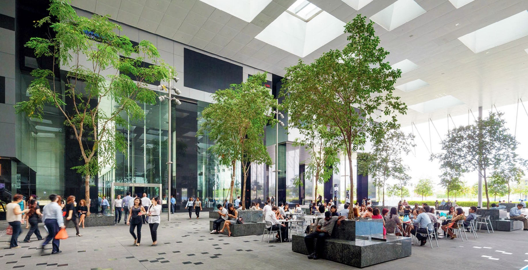
POPS at Asia Square Tower
Infrastructure & Streetscape
Works within the Road Reserves
To achieve a consistent district character, all new developments or those undergoing major additions and alterations are required to include the upgrading of the existing roadside tables within the adjacent Road Reserve, as specified below.
Open Walkway
As a guide, the open walkways within the Road Reserve are safeguarded for pedestrian use. The paving material within the open walkways are to match the paving requirements of the covered walkways. The paving pattern of the open walkways is to be coordinated with the covered walkways.
Dedicated Cycling Routes
Certain key roads within the Downtown Core Planning Area will be earmarked as dedicated cycling routes. The alignment, width and design of the cycling routes and associated street furniture are to be coordinated with URA and LTA.
For more information, please refer to the Special Detailed Control Plan: Connectivity Plan.
Tree and Shrub Planting Specifications
The tree and shrub planting specifications for the planting verge within the adjacent Road Reserve are provided as guidance on the species for roadside planting along key streets in Downtown. The planting proposals remain subject to URA and NParks’ requirements and approval. The planting verge shall be porous with sufficient breaks to allow pedestrian movement where meaningful.
For more information, please refer to Appendix 6: Landscaping Requirements for Key Streets
Connection to Commuter Facilities
For developments adjacent to commuter facilities (e.g. bus stops and taxi stands) located in front of their buildings, sheltered linkways are to be included between the covered walkways at the 1st storey to these facilities to provide direct continuous sheltered connections.
Street Lighting, Bollards and Tactile Tiles
To create a distinctive district character for the Central and Bayfront subzones, the public street lighting furniture within the Road Reserve is to be Polo+Signum luminaire in ‘Oxyplast PR11/14060/CT Sanded Sliver Grey Finish’. The spacing and location of the public street lighting is to be coordinated with the other street furniture and landscaping within the Road Reserve and is subject to the approval of the relevant Competent Authorities. Where required, stainless steel tactile tiles and bollards are to be installed at key pedestrian crossings, kerb cuts, or vehicular ingress / egress points to the drop-offs or car parks or service areas within the Road Reserve.
Servicing, Vehicular Access and Car Parks
To maintain an attractive streetscape, where specified, sites that front onto major roads and key streets are required to locate all service areas, including refuse bin centre(s), loading / unloading bays and vehicle storage lane(s), within the basement levels of the development and fully integrated within the overall building form, and visually screened from above and on all sides. Electrical substation(s), where required, can be located at-grade but are not to front onto the main roads, pedestrian malls, or public spaces. Where basement levels cannot be provided due to technical / site constraints, such service areas are to be fully integrated within the building envelope but are not to be located fronting main roads.
All vehicular ingress / egress to car parks, service areas, passenger drop-off / pick-up points and taxi lay-bys, etc., including external ramps, all associated structures and fixtures, are to be well-integrated with the building form and overall architectural treatment of the development. In general, vehicular ingress / egress and kerb cuts are to be minimised to reduce conflict between vehicles and pedestrians/cyclists. Sufficient holding bays for the vehicular access points to the car parks and service areas are to be provided within the development to ensure the smooth flow of vehicles along adjacent roads.
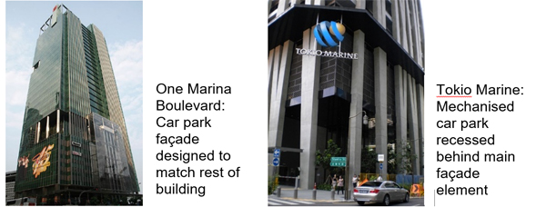
For developments at key approaches to the CBD, fronting onto major roads and open spaces, all car parking areas are required to be located in the basement levels. For all other developments, the car parking areas are encouraged to be located in the basement levels. Where there are technical / site constraints, and the car parks are located above grade, they are to be located away from the building frontages onto major roads, key streets, through-block links, public spaces, and where specified, to be set back from the facade to provide active uses (office, retail, etc.) fronting the adjacent roads and spaces. Where the site configuration does not allow for active uses to be incorporated, the facade of the car parking floors is to be designed to match the rest of the building facades (e.g. opaque curtain wall).
Night Lighting
All developments in the Civic District, Marina Bay and Marina Centre are required to include night lighting that expresses the architectural design and building form to contribute to the nighttime skyline of the city.
For more information, please refer to the Night Lighting Guidelines for Developments in the Central Business District (CBD), Civic District, Marina Bay and Marina Centre.
Creative Hoarding
Where required, developments shall provide Creative Hoarding at construction sites to enhance the streetscape and create a more attractive and vibrant environment. The hoarding may incorporate commissioned artworks, community-produced graphics, or vertical greenery such as creepers and green walls. Where vertical greenery cannot be accommodated, large-scale photographic decals of greenery may be used as an alternative.
Creative Hoarding shall be installed along key frontages of the development, i.e. fronting main streets and pedestrian routes. A minimum of 75% of the required creative hoarding length shall be covered with artwork or greenery.
For more information, please refer to the Creative Hoarding Guide.
Resources
Annexes & Appendices
Annex A: Urban Design Requirements for Anson and Cecil subzones [PDF, 570.83 KB]
Appendix 3: 1st Storey Pedestrian Network and Activity-Generating Uses Plan
Appendix 4: Underground Pedestrian Network and Activity-Generating Uses Plan
Appendix 5: Elevated Pedestrian Network and Activity-Generating Uses Plan
Appendix 6: Landscaping Requirements for Key Streets [PDF, 169 KB]
Relevant Guidelines & Circulars
Updated Urban Design Guidelines and Plans for Urban Design Areas
Restrictions On The Strata Subdivision of Commercial Properties
Screening of Mechanical and Electrical Services and Car Parks
Guidelines to Encourage More Innovative and Better Design of Rooftop
Update to the Design Guidelines for Privately Owned Public Spaces (POPS)