
Singapore River
Singapore River Planning Area is a thriving hub of activity with historic buildings, buzzing nightlife and quality waterfront city living. Its urban design guidelines focus on capitalising on its heritage as a waterfront lifestyle destination, with pedestrian-friendly waterfronts and promenades.
Last updated 17 June 2026
These urban design guidelines aim to guide the physical development of the area to ensure that individual buildings contribute to, and strengthen the planning vision for the respective zones and create an attractive and pedestrian-friendly physical environment.
Innovative designs that do not fully conform to the guidelines or standard building typologies, but are able to achieve the planning objective relevant to the requirement can be considered, subject to URA’s evaluation of the detailed proposal.
Gazetted monuments and conserved buildings are subject to specific preservation and conservation guidelines respectively, which will take precedence over the guidelines below.
Broad Positioning & Land Use
The following section is to be read together with the following plans:
The Singapore River Planning Area is envisioned to be an exciting activity corridor that capitalises on the river frontage and reflects its unique historic character. It stretches 3km long and has three distinctive subzones, namely Boat Quay, Clarke Quay, and Robertson Quay. A tree-lined pedestrian promenade and bridges have been implemented along both banks of the river, connecting the three quays and enhancing the pedestrian friendliness along the river corridor.
Boat Quay
The Boat Quay subzone is predominantly zoned for Commercial uses due to its proximity to the Central Business District. There are two conservation areas in this subzone, i.e. the Boat Quay Conservation Area, which is a key historic district with over 100 artfully conserved shophouses, and the Upper Circular Road Conservation Area, which is a secondary settlement with buildings of mainly Modern and Art Deco architectural styles.
Clarke Quay
The Clarke Quay subzone has a mix of Commercial, Hotel and Residential uses. Consisting of mainly conserved warehouses, the Clarke Quay Conservation Area offers many entertainment and lifestyle options, while the Magazine Road Conservation Area has a good cluster of conserved and new buildings for mixed use developments.
Robertson Quay
The Robertson Quay subzone, located at the upstream portion of the river, has a mix of different uses, including waterfront residences and hotels. Arts-related facilities housed in the conserved buildings help to further diversify the offerings.
Building Form & Massing
The following section is to be read together with the following plans:
The overall building form and massing of individual buildings is to consider the scale, form and architectural expression of the surrounding buildings. Buildings shall be designed to contribute positively to the skyline profile of the city and pedestrian experience along the riverfront promenade. The design of the building form and massing, together with the architectural treatment, is to consider how the building will be viewed as well as impact views from major approaches, key open spaces, promenade and pedestrian malls.
Several buildings within Robertson Quay which were built of the style of the former warehouses that lined the river are to be retained. This includes the existing building and roof profiles, as well as the solid and void expression and key features of the front facade.
For developments with building form requirements, alternative configurations of the greenery provisions can be considered, subject to relevant agencies’ approval.
Building Height
Different building heights are specified for individual precincts to create a layered, three-dimensional skyline profile, to respond to the specific site context and to reinforce the character of the district. In general, lower-rise heights are specified where there is a need to maintain a pedestrian-friendly scale, for example, along the riverfront promenade and to be compatible to the low-rise conserved buildings.
The maximum allowable building height is generally higher for the non-river fronting portion and is subject to the prevailing Master Plan controls and technical height controls imposed by the technical agencies. Urban Design height controls will take precedence over technical height controls, whichever is lower.
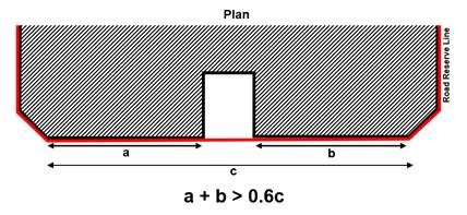
Building Edge
To create distinctive and well-defined streets, developments are generally to be built-up fully to the lines of Road Reserve / Promenade Reserve to a minimum height of 2 storeys, unless otherwise stated.
Up to 40% per building frontage, between the corners of the development, can be set back from the lines of Road Reserve / building setback lines if applicable, for articulation of the building form.
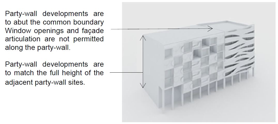
Party Wall Developments
Party wall developments are required to abut the common boundary with the adjacent sites and match the podium levels or the full height of the developments.
Window openings and facade articulation are not permitted along the party wall.
Roofscape
The roof areas of both the high-rise and low-rise parts of developments are to be considered as the “fifth” elevations and designed to complement the overall form, massing and architectural treatment of each development and articulated to contribute to a distinctive and coherent character for Singapore River.
To better relate to the conserved / retained buildings, all developments at Robertson Quay subzone (pictured below) are to have terracotta clay-tiled pitched roofs as the predominant roof form.
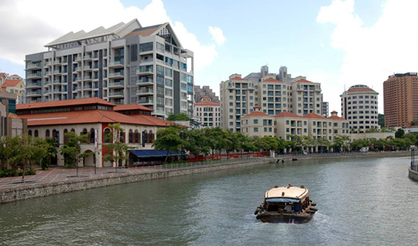
The pitched roof of new developments, such as this building next to the conserved shophouse (currently occupied by STPI - Creative Workshop & Gallery) ensures that the new buildings compliment the conserved buildings.
Robertson Quay: Coherent roofscape contributes to the precinct character.
Flat roofs, where allowed, can be designed to be usable outdoor spaces. All service areas, car parks, Mechanical and Electrical (M&E) equipment, water tanks, etc, are to be fully integrated within the overall building envelope and visually well-screened from the top and on all sides.
For more information, please refer to Screening of Mechanical and Electrical Services and Car Parks and Guidelines to Encourage More Innovative and Better Design of Rooftop (Part A. Relaxation of the Gross Floor Area (GFA) Exemption Guidelines for Rooftop Covers)
Greenery Replacement and Landscaping
To create a green and sustainable city, all new developments will be required to incorporate landscaping in the form of sky terraces and roof gardens according to the Landscape Replacement Area (LRA) requirements.
For more information, please refer to the Development Control Handbook.
Connectivity & Active Uses
The following section is to be read together with the following plans:
The Singapore River Planning Area is planned as a pedestrian-friendly area with a comprehensive pedestrian network. The focus on the pedestrian network is on the street level (i.e. at-grade), in particular along and towards the riverfront promenade to provide convenient, comfortable and seamless connections between developments, transport facilities, key spaces and attractions, and ensure all weather comfort for pedestrians.
The pedestrian network on all levels is to be designed for universal access. GFA exemption can be considered for public spaces, covered walkways, through-block links and elevated walkways, subject to the prevailing Development Control Guidelines.
At-Grade Pedestrian Network
The riverfront promenade along the Singapore River not only connects the three quays together but also ensures that prime riverfront space is safeguarded for public access and enjoyment. The promenade is connected on both banks by bridges. Developments are required to be setback from the river wall for the 15.0m wide promenade that comprises footpath, cycling path, landscaping, and public amenities such as street lamps and benches.
The at-grade pedestrian network is augmented by covered walkways that provide all-weather protected pedestrian routes, including along the river. All developments are required to provide covered walkways at the 1st storey along the site boundaries or the designated setback lines. The covered walkways function as public amenities. They are to be kept free of obstruction at all times.
The platform level of the open and covered walkways is to correspond with the adjacent road as far as possible. For open walkways that are below the minimum platform level, the covered walkways may be allowed below the minimum platform level so that they match the platform level of the open walkways. Any difference in levels between the internal platform level of the 1st storey and the covered walkway are to be mediated within the 1st storey of the development and not along the open walkways / covered walkways / linkways.
.png)
Open walkways below the Minimum Platform Level
The minimum widths of the covered walkways are either 3.0m or 3.6m depending on the category of road they are fronting onto. Where colonnades are provided, the internal clear widths of the covered walkways are to be 2.4m and 3.0m respectively. To provide adequate protection for pedestrians during inclement weather, the external soffit heights are to minimally match the width of the covered walkway.
The respective widths apply to the following identified road frontages in Robertson Quay:
Table 1: Identified road frontages
3.6m (3.0m clear) | 3.0m (2.4m clear) |
|---|---|
Singapore River Promenade | Caseen St |
Nanson Rd (Along Quayside) | Nanson Rd (Along Studio M & Intercontinental) |
Unity St | Rodyk St |
Merbau Rd | Robertson Quay |
Mohd Sultan Rd | |
Martin Rd | |
Clemenceau Ave | |
Saiboo St |
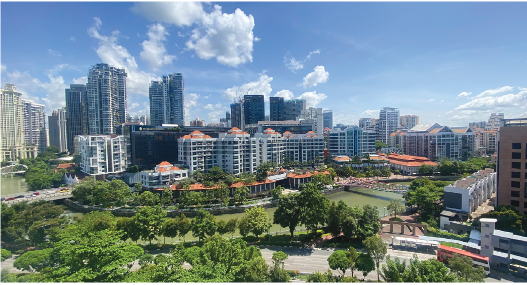
Through-Block Links and View Corridors
Selected developments, especially those with long frontages, are required to provide through-block links or view corridors to break down the scale and improve permeability of the street block and in particular, towards the riverfront. Specific design requirements have been imposed on some key sites, depending on the locations of these through-block links or view corridors.
The height of the through-block link is subject to detailed evaluation. The width of through-block links is to be 4.0m to 7.0m, unless otherwise specified, and have been indicatively marked in Appendix 3.
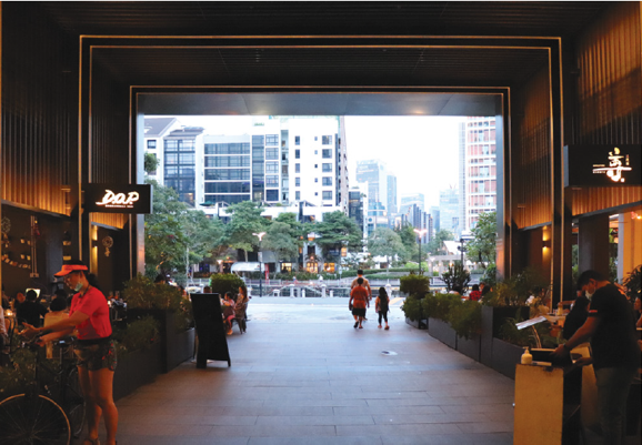
View towards river at The Quayside
Underground Pedestrian Network (UPN)
UPNs are to include vertical pedestrian circulation points within the building envelope to connect to the covered walkway at the 1st storey. Each vertical circulation point is to include a pair of two-way escalators, staircases and two passenger lifts. The entire UPN and the associated vertical circulation points are to be kept open for public access during the opening hours of the RTS.
Elevated Pedestrian Network (EPN)
The EPN complements the at-grade and underground pedestrian network to provide seamless connectivity between developments.
EPNs are to include vertical pedestrian circulation points within the building envelope to link to the covered walkways at the 1st storey. The entire EPN and the associated vertical circulation points are to remain open for the duration of the mall’s operating hours.
Uses at the 1st Storey
To create vibrant precincts, as well as attractive and pedestrian-friendly streets, activity-generating uses (AGU) such as retail, food and beverage (F&B), and other active uses are to be provided at the following locations:
The 1st storey of developments fronting the riverfront promenade, pedestrian malls, through-block links, key streets and public spaces.
For more information on AGUs, please refer to the Development Control Handbook.
Outdoor Refreshment Areas
Outdoor Refreshment Areas (ORA) can be allowed along the riverfront promenade and considered within public areas or open spaces within private development sites. The scale and design of the ORA and its structures (if any) are to complement the adjacent building. They can only be considered as an extension of an adjoining indoor F&B unit and are for seating only.
Developers are encouraged to incorporate spaces for ORAs at the design stage. The ORAs are to be clearly defined to prevent encroachment onto the adjacent pedestrian thoroughfares e.g. through the use of different floor finishes or planters, etc.
For more information, please refer to the Updated Guidelines for Outdoor Refreshment Area (ORA) along Singapore River Promenade for Robertson Quay and Clarke Quay [PDF, 5.82 MB] (Annex A); and; Guidelines for Outdoor Kiosks and Outdoor Refreshment Areas (ORA) at Boat Quay Promenade [PDF, 1.15 MB] (Annex B)
Public Space
It is important to provide public spaces within private developments for users to enjoy.
Selected developments fronting the riverfront promenade, key pedestrian malls or nodes are required to provide public open spaces within the development site. These may be well-landscaped open spaces or covered public spaces that provide a high degree of visual and physical porosity through the building.
Public spaces are to be publicly accessible at all times. They are to be connected to the key pedestrian routes at the 1st storey (such as the river promenade, adjacent open and covered walkways, and through-block links), and, where applicable, are to be linked and designed to be well-integrated and easily accessible from the underground and elevated 2nd storey pedestrian networks within the development.
The design of these public spaces shall comply with the Design Guidelines for Privately Owned Public Spaces (POPS).
Infrastructure & Streetscape
Works within the Road Reserves
The following section is to be read together with:
To achieve a pedestrian-friendly and consistent district character, all new developments or developments undergoing major Additions and Alterations fronting the river are required to include the upgrading of the existing riverfront promenade as part of the works. The key elements to consider are tree planting, paving materials, pedestrian walkways and street lighting etc.
The detailed guidelines for each quay are different to enhance the character of each quay and to better relate to the historic river wall profiles that varies along the river.
Open Walkway
As a guide, the open walkways within the Road Reserves are safeguarded for pedestrian use. Walkways along Clarke Quay are to be paved in grey granite and coordinated with the existing paving pattern within the covered walkway.
Dedicated Cycling Routes
Certain key roads within the Singapore River Planning Area will be earmarked as dedicated cycling routes. The alignment, width and design of the cycling routes and associated street furniture are to be coordinated with NPARKS, LTA, and URA.
For more information, please refer to the Special Detailed Control Plan: Connectivity Plan.
Servicing, Vehicular Access and Car Parks
To maintain an attractive streetscape, all service areas, including refuse bin centre(s), loading / unloading bays, and vehicle storage lane(s), are to be located away from the riverfront promenade and fully integrated within the overall building form, and visually screened from above and on all sides. Electrical substation(s), where required, can be located at-grade but are not to front onto riverfront promenade, pedestrian malls or public spaces.
All vehicular ingress / egress to car parks, service areas, passenger drop-off / pick-up points and taxi lay-bys, etc, including external ramps, all associated structures and fixtures, are to be well-integrated with the building form and overall architectural treatment of the development. Sufficient holding bays for the vehicular access points to the car parks and service areas are to be provided within the development to ensure the smooth flow of vehicles along adjacent roads.
All car parks are not to front the riverfront promenade. Developments fronting the riverfront promenade are encouraged to provide basement car parks. Where there are technical / site constraints, any above-grade car parks are to be located away from promenade and open space, and to be set back from the facade to provide active uses (retail, F&B etc) fronting onto the promenade. Where the site configuration does not allow for active uses to be incorporated, the facade of the car parking floors is to be designed to match the rest of the building.
Night Lighting
All commercial developments within Clarke Quay and Boat Quay are encouraged to have a well-designed night-lighting scheme to reinforce the unique setting of the development when seen from the river promenade and street level.
Any night lighting of the building form and crown, shall be subtle, such that the night lighting of the development is appropriate and sensitive when viewed from Fort Canning Park.
Creative Hoarding
Where required, developments shall provide Creative Hoarding at construction sites to enhance the streetscape and create a more attractive and vibrant environment. The hoarding may incorporate commissioned artworks, community-produced graphics, or vertical greenery such as creepers and green walls. Where vertical greenery cannot be accommodated, large-scale photographic decals of greenery may be used as an alternative.
Creative Hoarding shall be installed along key frontages of the development, i.e. fronting main streets and pedestrian routes. A minimum of 75% of the required creative hoarding length shall be covered with artwork or greenery.
For more information, please refer to the Creative Hoarding Guide.
Resources
Annexes & Appendices
Relevant Guidelines & Circulars
Updated Urban Design Guidelines and Plans for Urban Design Areas
Design and Submission Guidelines for Implementation of Singapore River Promenade (Revised 1999)
Screening of Mechanical and Electrical Services and Car Parks
Guidelines to Encourage More Innovative and Better Design of Rooftop
Update to the Design Guidelines for Privately Owned Public Spaces (POPS)