
Rochor
Rochor Planning Area is Singapore’s arts, culture, and education district. The urban design guidelines focus on preserving the area’s rich architectural and cultural heritage, while facilitating its development into a renowned education and learning hub.
Last updated 17 June 2026
The Bras Basah.Bugis (BB.B) district comprises part of the Rochor and Museum Planning Areas and is strategically located close to the premier Orchard Road shopping belt and the Civic District. Envisioned to be a lively, arts, education and heritage enclave, BB.B is home to many of Singapore’s arts, cultural and educational facilities, including Waterloo Street Arts Belt, LaSalle College of the Arts, Nanyang Academy of Fine Arts, University of the Arts, School of the Arts (SOTA), and upcoming Singapore University of Social Sciences.
These urban design guidelines aim to guide the physical development of the area to ensure that individual buildings contribute to, and strengthen the planning vision for the respective zones and create an attractive and pedestrian-friendly physical environment.
Innovative designs that do not fully conform to the guidelines or standard building typologies, but are able to achieve the planning objective relevant to the requirement can be considered, subject to URA’s evaluation of the detailed proposal.
Gazetted monuments and conserved buildings are subject to specific preservation and conservation guidelines respectively, which will take precedence over the guidelines below.
Broad Positioning & Land Use
The following section is to be read together with the following plans:
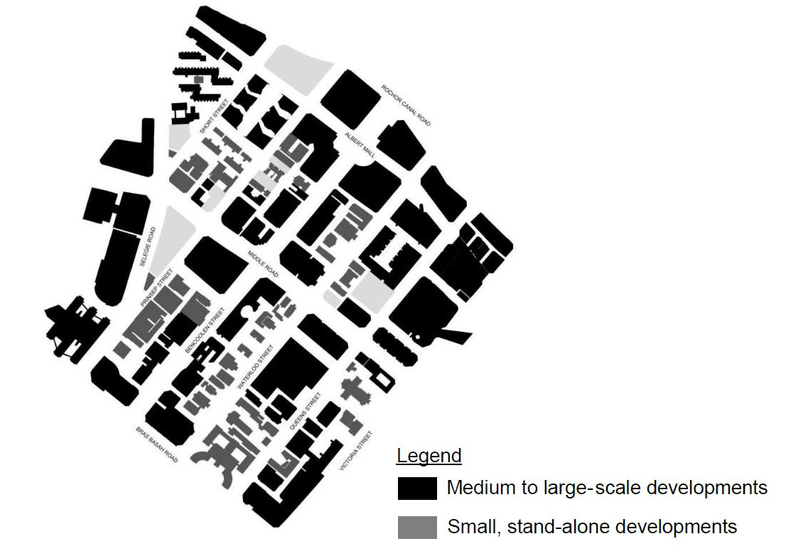
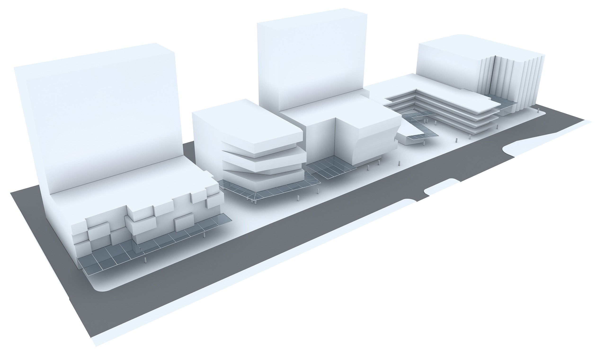
Figure-ground diagram of Bras Basah.Bugis
Envisioned to be a lively, arts, education and heritage district, BB.B has an eclectic mix of uses and building types. These include shophouses, standalone religious buildings, schools, as well as medium to large-scale commercial buildings, and public housing
Medium to large-scale developments in BB.B are predominantly located along the major arterial roads – Bras Basah Road, Selegie Road, Rochor Canal Road, Victoria Street, Bencoolen Street, Middle Road, and Albert Mall. The smaller-scale, stand-alone buildings (many of which are heritage buildings) are predominantly located along the other streets – Short Street, Prinsep Street, Waterloo Street, and Queen Street. Differentiated urban design guidelines are applicable for different streets, taking into consideration the existing character of each street.
The guidelines aim to achieve the following:
Varied Streetscape
Innovative and varied building forms and scale, as well as shop fronts with high levels of transparency, will enhance the street experience.A Pedestrian-Friendly District
Connectivity between developments via a comprehensive network of pedestrian malls, covered walkways and laneways in between buildings will facilitate a more walkable district. For the larger-scale developments, permeability at the ground level is important to allow pedestrians to walk through the buildings.Active Vibrant Streets
A series of public spaces that are connected by pedestrian malls and walkways are safeguarded for the public enjoyment and for organised events and spontaneous activities to occur.
Building Form & Massing
The following section is to be read together with the following plan:
The building form and massing is to be designed taking into consideration the scale, form and architectural expression of the surrounding buildings, to enhance the varied character of the different streets in BB.B.
For developments with building form requirements, alternative configurations of the greenery provisions can be considered, subject to relevant agencies’ approval.
Building Height
Different building heights are specified to respond to the site context and to reinforce the character of the district. In general, the overall building height steps up away from Mount Sophia to retain a lower-rise character around the hill.
A low-rise, 2 or 4-storey zone is specified for selected developments along Albert Mall, Waterloo, Queen and Prinsep Streets. High-rise towers, if proposed, are to be set back 7.5 or 15.0m away from line of Road Reserve, to maintain an intimate pedestrian-friendly scale along these streets.
The maximum allowable building height is subject to the prevailing Master Plan controls and technical height controls imposed by the technical agencies. Urban Design height controls will take precedence over technical height controls if the former is lower.
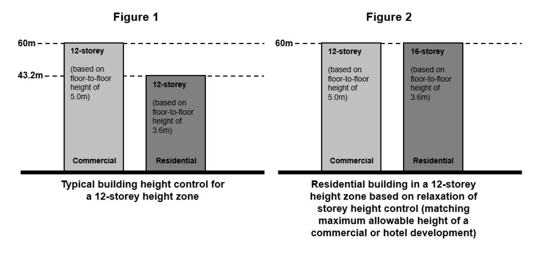
Residential Developments
For Residential developments within BB.B, an equivalent building height to the maximum allowable height for a commercial building can be considered to give greater design flexibility (see Figure 1 and 2). Notwithstanding this, the current development controls on maximum floor-to-floor heights for residential buildings will continue to apply.
Please note that the height relaxation is not applicable to the following:
Developments within Conservation Areas;
Developments within Special Detailed Control Areas, including those guided by street block plans, envelope controls, areas with particular urban design guidelines for building height;
Developments within height control of 6 storeys or less.
Building Setback and Building Edge
The building edge of developments helps to define the streetscape and urban spaces within the city.
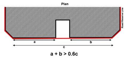
Developments along the major arterial roads – Bras Basah Road, Selegie Road, Rochor Canal Road, Victoria Street, Middle Road, and Bencoolen Street, as well as Albert Mall – are to be built up to the line of Road Reserve, to a minimum of 2 storeys to provide a well-defined streetscape, taking reference from the scale of the existing developments.
Up to 40% per building frontage, between the corners of the development, is encouraged to be set back from lines of Road Reserve for articulation of the building form.
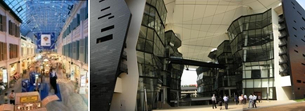
Creative expression of the overall building form and architectural treatment is highly encouraged, with a variety of building materials and textures, integrated facade lighting and landscaping, to provide interest and variety to the streetscape. A high degree of transparency and porosity is also encouraged, especially at the street level.
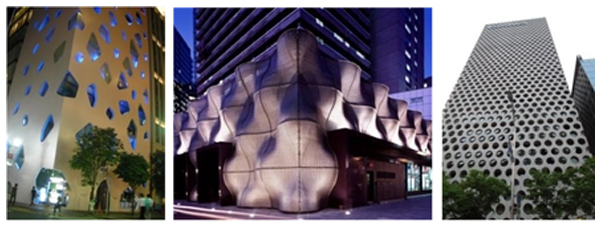
Examples of a variety of building edge treatment
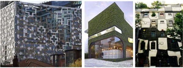
Different architectural expressions are encouraged to prevent a uniform quality amongst the developments.
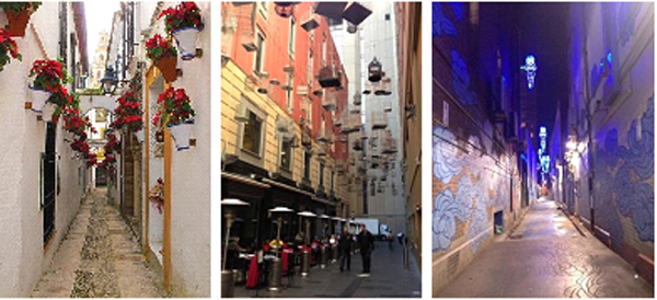
Facade articulation, as well as use of colours and textures, provides interest and variety to the building edges and streetscape. The developments along other streets – Short Street, Prinsep Street, Waterloo Street, and Queen Street – need not be built up to the line of Road Reserve. This is because many of the small-scaled buildings on these streets are mainly stand-alone heritage buildings or places of worship with unique building forms. Where developments are set back from the line of Road Reserve, the area fronting the development is to be landscaped as attractive and accessible public spaces. Open air car parks, as well as gates and boundary walls that obstruct public access will not be allowed within the building setback.
Example of a street where a building edge is not required and are set back from the line of Road Reserve to provide public spaces in front of the developments.
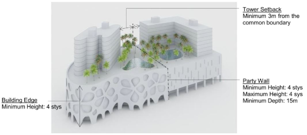
Party Wall Developments
The BB.B district has an eclectic mix of different building typologies, ranging from traditional shophouses to small and medium-scale modern developments.
Most of the existing developments are built up to the common boundary with the adjacent developments with a party wall. This maximises the footprint of the building and creates a continuous pedestrian walkway between developments. Developments within these street blocks are to be built up to the common boundaries as party wall developments.
In general, no openings are allowed along party walls, as these will be obstructed by the future adjacent party wall development.
Standalone buildings, where party walls are not required, are to be set back 3.0m (minimum) from the common boundary.
Guidelines for Commercial Street Block
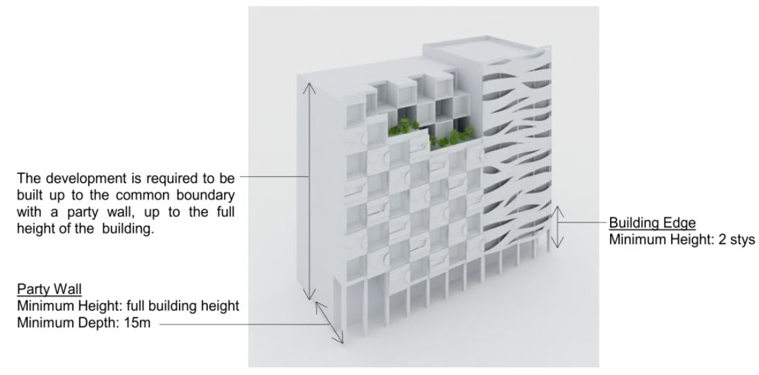
Party wall developments are to be built up to the common boundary, up to the full height of the building.
Guidelines for Residential Street block (Prinsep Street)
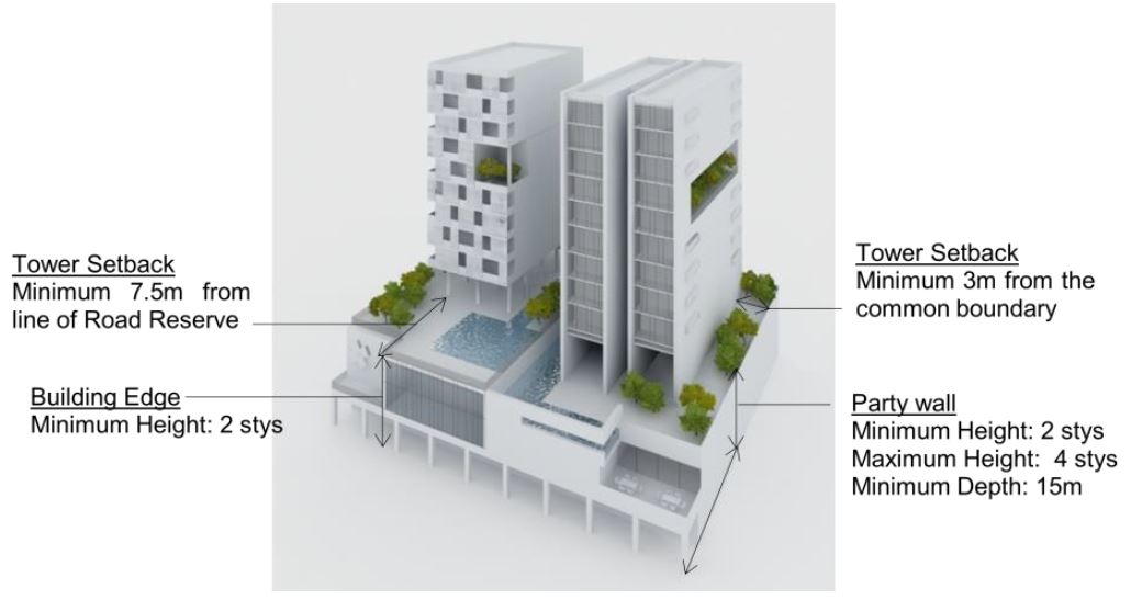
Party wall developments are to be built up to the common boundary up to a minimum of 2 storeys and not exceeding 4 storeys. Beyond the height of 4 storeys, the building is to be set back minimally 3.0m from the common boundary, and 7.5m from the line of Road Reserve. This allows for more window openings in the residential developments.
Guidelines for Selegie Road
The mixed-use developments along Selegie Road are to be built up to the common boundary up to 4 storeys. In view of the relatively large building footprint, the tower blocks above the podium are to be set back 3.0m (minimum) from the common boundary. This prevents wall-like developments and provides opportunities for more window openings within the mixed-use development.
Roofscape
The roof areas are to be considered as the “fifth” elevation and designed to complement the overall form, massing and architectural treatment of each development. The roofs can be designed to be usable outdoor spaces.
All service areas, car parks, Mechanical and Electrical (M&E) equipment, water tanks, etc, are to be fully integrated within the overall building envelope and visually well-screened from the top and on all sides.
For more information, please refer to the Screening of Mechanical and Electrical Services and Car Parks and Guidelines to Encourage More Innovative and Better Design of Rooftop (Part A. Relaxation of the Gross Floor Area (GFA) Exemption Guidelines for Rooftop Covers)
Greenery Replacement and Landscaping
To create a green and sustainable city, all new developments will be required to incorporate landscaping in the form of sky terraces and roof gardens according to the Landscape Replacement Area (LRA) requirements.
For more information, please refer to the Development Control Handbook.
Connectivity & Active Uses
The following section is to be read together with the following plans:
BB.B is envisioned to be a pedestrian-friendly district, with a comprehensive network of pedestrian malls, through-block links, covered walkways, 2nd storey links, and laneways in between buildings, to allow people to move easily and comfortably.
The shop fronts along the pedestrian network are encouraged to be designed with high levels of transparency, with multiple points of entry into the building at the 1st storey, to achieve an active street front.
The pedestrian network on all levels is to be designed for universal access. GFA exemption can be considered for public spaces, covered walkways, through-block links and elevated walkways, subject to the prevailing Development Control Guidelines.
Pedestrian Malls and Public Spaces
Albert and Waterloo Malls, which were planned and implemented by URA, have become the main pedestrian thoroughfares in the district and a magnet for the local community and tourists to savour its colourful, eclectic and vibrant street life. Queen Street and Waterloo Street are planned for widened pedestrian walkways that can host arts-related events for public enjoyment. Selected developments along Albert Mall, Queen Street and Waterloo Street are to contribute public spaces within the development boundary to complement the pedestrian malls.
In addition, a series of public footpath of minimum 1.5m width that are located along building setbacks of identified buildings at Waterloo Street, Queen Street and Prinsep Street are meant to provide alternative pedestrian routes or short cuts through the street blocks, and connect areas with expected high pedestrian traffic, e.g. between the upcoming Bencoolen Station and Victoria Street. Building facades fronting these footpaths are encouraged to feature art works/shop windows. This will heighten the sense of place as well as add interest and variety to the pedestrian experience.
Through-Block Links
Through-block links allow pedestrians to move directly through large building blocks, thereby improving ground level permeability and pedestrian connectivity. A network of streets that form an extension of Albert and Waterloo Malls is planned through the provision of through-block links within developments fronting the malls.
Another network of planned through-block links and laneways south of Middle Road will help to provide alternative pedestrian routes through the street blocks connecting to the Bencoolen MRT station. The internal clear width of a through-block link is to be 4.0m to 7.0m wide, unless otherwise specified.
Covered Walkways
All developments are to provide covered walkways, except for conserved buildings that do not have covered walkways. Along major arterial roads, where building edge is required, the covered walkway is to abut the Road Reserve. Along the other streets, the covered walkway can be set back from the line of Road Reserve, following the articulation of the building form. The covered walkways function as public amenities. They are to be kept free of obstruction at all times.
The platform level of the open and covered walkways is to correspond with the adjacent road as far as possible. For open walkways that are below the minimum platform level, the covered walkways may be allowed below the minimum platform level so that they match the platform level of the open walkways. Any difference in levels between the internal platform level of the 1st storey and the covered walkway are to be mediated within the 1st storey of the development and not along the open walkways / covered walkways/linkways.
.png)
Open walkways below the Minimum Platform Level
The covered walkway is to be minimally 3.6m wide, unless otherwise specified. Where colonnades are provided, the internal clear width of the covered walkway is to be minimally 3.0m wide. To provide adequate weather protection to pedestrians during inclement weather, the external soffit heights are to minimally match the width of the covered walkway.
Developments fronting Bras Basah Road are located at the fringe of Civic District. To achieve a distinct character within the Civic District (see Appendix 5), the covered and open walkways along identified streets are to be paved in predominantly 600mm x 600mm flamed finish heavy duty Rossa Porrino (or equivalent) granite tiles, set out perpendicular to the lines of Road Reserve. The remaining walkways within the Civic District are to be paved in predominantly 600mm x 600mm flamed finish heavy duty grey-green granite tiles, set out perpendicular to the lines of Road Reserve.
Elevated Pedestrian Network (EPN)
EPNs complement the at-grade pedestrian network and connect key commercial developments across major arterial roads at the fringe of the BB.B district. As a general guide, and unless otherwise specified, they are to be 4.0m to 7.0m wide.
Vertical pedestrian circulation points, including lifts, escalators and stairs, within the building envelope are required to link the EPN to the covered walkways at the 1st storey. The entire EPN and the associated vertical circulation points are to remain open for public use at all times, unless otherwise specified.
Uses at the 1st Storey
To encourage walkability, and active vibrant streets, Activity-Generating uses (AGU), such as retail, food and beverage, entertainment, and other active uses are to be provided at the 1st storey fronting key pedestrian thoroughfares along:
Albert Mall
Waterloo Street
Queen Street
Bencoolen Street
Prinsep Street
Key walkways and through-block links connecting to Queen Street and Waterloo Street
For more information on AGUs, please refer to the Development Control Handbook.
Outdoor Refreshment Areas
Albert Mall is one of the main pedestrian thoroughfares in the BB.B district. Outdoor Refreshment Areas (ORA) and Outdoor Display Area (ODA) can be allowed at selected locations on Albert Mall, subject to detailed evaluation and approval by URA and SLA. ORAs can also be allowed in the open spaces of the private development sites, as an extension of an adjoining indoor F&B unit and are for seating only. The scale and design of the ORA and its structures (if any) are to complement the adjacent building and are encouraged along the key pedestrian thoroughfares and laneways.
If provided, the Gross Floor Area (GFA) for the ORAs are to be computed as part of the maximum permissible GFA for the development, unless otherwise permitted under prevailing bonus GFA schemes.
The ORAs will be subject to the prevailing Development Control Guidelines issued by the Competent Authority under the Planning Act. Developers are encouraged to incorporate spaces for ORAs at the design stage. The ORAs are to be clearly defined to prevent encroachment onto the adjacent pedestrian thoroughfares e.g. through the use of different floor finishes or planters, etc.
Public Space
It is important to provide public spaces within private developments for users to enjoy.
Selected developments fronting key pedestrian malls or nodes are required to provide public open spaces within the development site. These may be well-landscaped open spaces or covered public spaces that provide a high degree of visual and physical porosity through the building.
Public spaces are to be publicly accessible at all times. They are to be connected to the key pedestrian routes at the 1st storey (such as pedestrian malls and promenades, adjacent open and covered walkways, and through-block links), and, where applicable, are to be linked and designed to be well-integrated and easily accessible from the underground and elevated 2nd storey pedestrian networks within the development.
The design of these public spaces shall comply with the Design Guidelines for Privately Owned Public Spaces (POPS).
For more information, please refer to the Update to the Design Guidelines for Privately Owned Public Spaces (POPS)
Infrastructure & Streetscape
Works within the Road Reserves
Open Walkway
As a guide, the open walkway within the Road Reserve is safeguarded for pedestrian use and where located within the Civic District, is to match the paving requirements of the covered walkways. The paving pattern of the open walkways is to be coordinated with the covered walkways.
Connection to Commuter Facilities
For developments with commuter facilities (e.g. bus stop and taxi stands) located in front of their buildings, sheltered linkways are to be provided between the covered walkways at the 1st storey to these facilities to provide direct continuous sheltered connections.
Dedicated Cycling Routes
Certain key roads within the Bras Basah.Bugis Urban Design Area will be earmarked as dedicated cycling routes. The alignment, width and design of the cycling routes and associated street furniture are to be coordinated with URA and LTA.
For more information, please refer to the Special Detailed Control Plan: Connectivity Plan.
Servicing, Vehicular Access and Car Parks
To maintain an attractive streetscape, any above-grade car park and service areas, including refuse bin centre(s), loading/unloading bays and vehicle ingress/ egress, storage lane(s), and lay-bys, etc are to be fully integrated within the overall building form, and visually well-screened from above and on all sides. Electrical substation(s), where required, can be located at-grade but are not to front onto the main roads, pedestrian malls, or public spaces.
Sufficient holding bays for the vehicular access points to the car parks and service areas are to be provided within the development to ensure the smooth flow of vehicles along adjacent roads.
For more information, please refer to the Screening of Mechanical and Electrical Services and Car Parks and Guidelines to Encourage More Innovative and Better Design of Rooftops (Part A. Relaxation of the Gross Floor Area (GFA) Exemption Guidelines for Rooftop Covers).
Night Lighting
Developments within the Civic District boundary are to provide night lighting to enhance the district character at night.
For more information, please refer to the Revision to the Night Lighting Guidelines for Developments in the Central Business District (CBD), Civic District, Marina Bay and Marina Centre.
Creative Hoarding
Where required, developments shall provide Creative Hoarding at construction sites to enhance the streetscape and create a more attractive and vibrant environment. The hoarding may incorporate commissioned artworks, community-produced graphics, or vertical greenery such as creepers and green walls. Where vertical greenery cannot be accommodated, large-scale photographic decals of greenery may be used as an alternative. Creative Hoarding shall be installed along key frontages of the development, i.e. fronting main streets and pedestrian routes. A minimum of 75% of the required creative hoarding length shall be covered with artwork or greenery.
For more information, please refer to the Creative Hoarding Guide.