
Orchard
Orchard Road Planning Area is a vibrant shopping street lined with retail malls, hotels, lifestyle and recreational offerings, along a grand tropical boulevard. Orchard’s urban design guidelines focus on ensuring good connectivity with the MRT station, accessibility between developments, a vibrant streetscape and encouraging innovative and high-quality design benefitting Orchard Road’s positioning as a must-visit lifestyle destination.
Last updated 17 June 2026
These urban design guidelines aim to guide the physical development of the area to ensure that individual buildings contribute to, and strengthen the planning vision for the respective zones and create an attractive and pedestrian-friendly physical environment.
Innovative designs that do not fully conform to the guidelines or standard building typologies, but are able to achieve the planning objective relevant to the requirement can be considered, subject to URA’s evaluation of the detailed proposal.
Gazetted monuments and conserved buildings are subject to specific preservation and conservation guidelines respectively, which will take precedence over the guidelines below.
Broad Positioning & Land Use
The following section is to be read together with the following plans:
Orchard Road is predominantly a lifestyle and retail belt with a generous tree-lined pedestrian mall that runs through the district, connecting major developments, public open spaces and MRT stations.
The area is mainly zoned Commercial to support a mix of shops, offices and hotels. There are also several sites zoned for Hotel use to enhance the attractiveness of Orchard Road as one of Singapore’s key tourist destinations. Orchard Road is also supplemented by a number of Residential and mixed Commercial and Residential sites that inject a live-in population to the area to ensure round-the-clock vibrancy.
Orchard Road brings together unique sub-precincts with different personalities - Tanglin, Orchard, Somerset and Dhoby Ghaut. New retail concepts and lifestyle attractions are encouraged to enhance the unique characters of each precinct.
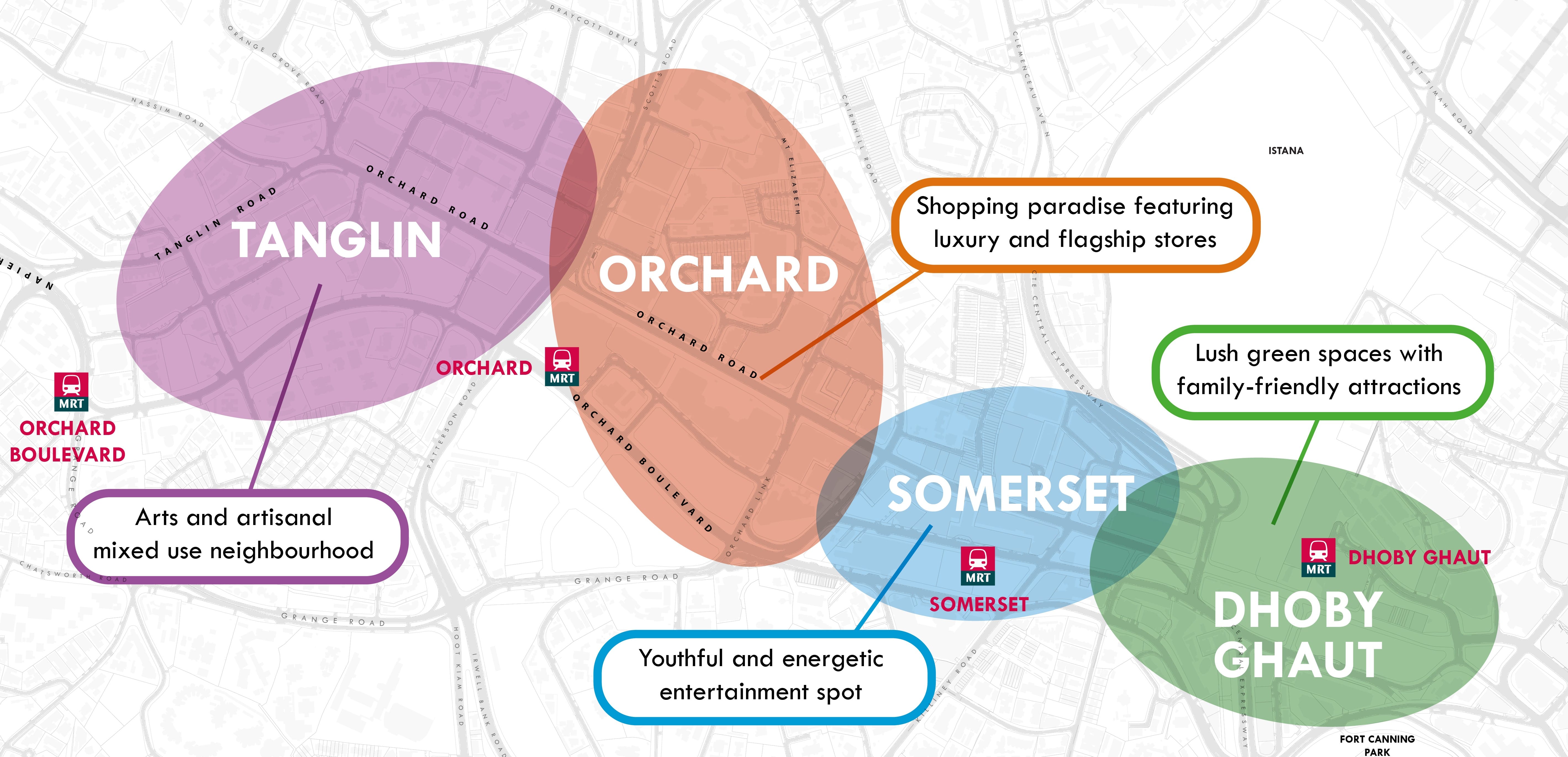
Positioning of Orchard Road sub-precincts
The Urban Design guidelines for Orchard Planning Area aim to achieve:
A Walkable and Pedestrian-Friendly District - by ensuring seamless, all-weather connectivity and accessibility between developments and the MRT stations; and
An Attractive and Vibrant Streetscape - by encouraging innovative design, varied building forms, attractive public spaces and various active uses along the Orchard Road pedestrian mall.
Innovative projects of high quality that do not fully conform to the prevailing guidelines and planning parameters can be considered under the Strategic Development Incentive (SDI) Scheme.
Building Form & Massing
The following section is to be read together with the following plans:
The overall building form and massing of individual buildings is to consider the scale, form and architectural expression of the surrounding buildings. Buildings shall be designed to contribute positively to the skyline profile of the city and pedestrian experience along the pedestrian mall. The design of the building form and massing, together with the architectural treatment, is to consider how the building will be viewed as well as impact views from major approaches, key open spaces and pedestrian malls, as well as to create engaging and varied shopfronts along the pedestrian mall.
For developments with building form requirements, alternative configurations of the greenery provisions can be considered, subject to relevant agencies’ approval.
Building Height
Different building heights are specified for individual precincts to create a layered, three-dimensional skyline profile, to respond to the specific site context and to reinforce the character of the district.
In general, the overall building height is higher around Orchard MRT station, marking it the gateway to Orchard Road. The building heights step down towards the Somerset and Tanglin Road areas.
The maximum allowable building height is subject to the prevailing Master Plan controls and technical height controls imposed by the technical agencies. Urban Design height controls will take precedence over technical height controls if the former is lower.
Residential Developments
For Residential developments within Orchard Planning area, an equivalent building height to the maximum allowable height for a commercial building can be considered to give greater design flexibility (see Figure 1 and Figure 2). Notwithstanding this, the current development controls on maximum floor-to-floor heights for residential buildings will continue to apply.
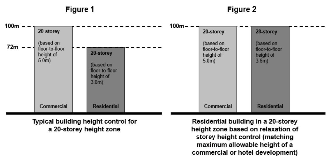
Please note that the height relaxation is not applicable to the following:
Developments within Conservation Areas;
Developments within Special Detailed Control Areas, including those guided by street block plans, envelope controls, areas with particular urban design guidelines for building height;
Developments within height control of 6 storeys or less.
Building Setback and Building Edge
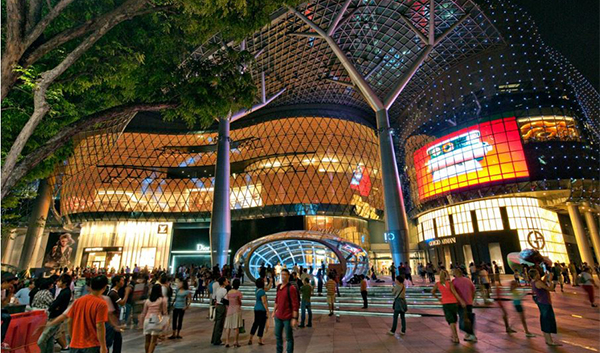
Orchard Road has a signature image of a wide tropical boulevard flanked by trees and buildings that reinforce and define the street by relating to a common building setback line.
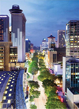
The grand boulevard effect of Orchard Road is reinforced by a consistent building edge on both sides of the street. (Image courtesy of DP Architects Pte Ltd).
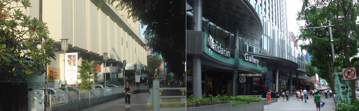
Developments along Orchard Road and Scotts Road are to be set back 7.6m or 11.6m from the line of Road Reserve. This is to safeguard the generous pedestrian malls on both sides of the street, which have become vibrant staging grounds for outdoor refreshment areas, activities and events. Along Orchard Boulevard, developments are to be set back 7.6m from the line of Road Reserve to provide a lushly landscaped green buffer to complement the tree-lined boulevard.
In order to maintain the well-defined urban streetscape, these buildings are also to be built-up to the required building setback line. For developments with building edge requirements up to the lines of Road Reserve, alternative configurations of the green buffer can be considered, subject to relevant agencies’ approval.
Up to 40% of the building frontage can be set back further from the building setback line for articulation of the building form, so that a variety of spaces, as well as interesting building fronts can be created.
Up to 50% of the podium facade area can also be projected within the building setback, in the form of facade articulations, to create more interesting and varied building frontages.
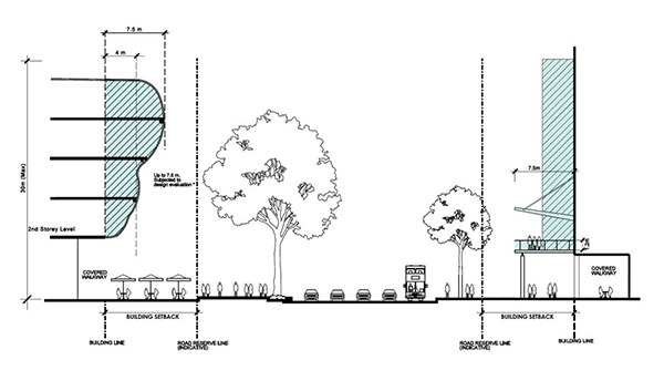
Façade Articulations are allowed to project into the building setback area
Buildings featuring multi-storied shop fronts with a high level of transparency and attractive lighting are highly encouraged to add vibrancy and variety to the streetscape.
For more information on facade articulation, please refer to Annex B [PDF, 1.68 MB].
Party Wall Developments
Selected developments are to be built up to abut the common boundary of the development to create party wall developments, which abut the common boundary with the adjacent sites and match the podium levels or the full height of the developments. This allows developments to maximise the building footprint and creates a continuous pedestrian walkway between developments. Window openings and facade articulation are not permitted along the party wall.
Above the party wall, developments are to be set back by a minimum of 3.0m from the common boundary for window openings. For residential towers, the residential towers are to be set back from the common boundary according to the Development Control Guidelines.
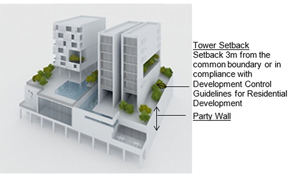
Building setback requirement from party wall.
For more information, please refer to Annex C [PDF, 630.53 KB].
Roofscape
The roof areas of both the high-rise and low-rise parts of developments are to be considered as the “fifth” elevations and designed to complement the overall form, massing and architectural treatment of each development and articulated to contribute to the skyline profile. The roofs can be designed to be usable outdoor spaces.
All service areas, car parks, Mechanical and Electrical (M&E) equipment, water tanks, etc., are to be fully integrated within the overall building envelope and visually well-screened from the top and on all sides.
For more information, please refer to Screening of Mechanical and Electrical Services and Car Parks and Guidelines to Encourage More Innovative and Better Design of Rooftop (Part A. Relaxation of the Gross Floor Area (GFA) Exemption Guidelines for Rooftop Covers)
Greenery Replacement and Landscaping
To create a green and sustainable city, all new developments will be required to incorporate landscaping in the form of sky terraces and roof gardens according to the Landscape Replacement Area (LRA) requirements.
For more information, please refer to the Development Control Handbook.
Connectivity & Active Uses
The following section is to be read together with the following plans:
The Orchard Planning Area is planned as a pedestrian-friendly area via a comprehensive pedestrian network at the 1st storey, basement, and 2nd storey. This network provides convenient, comfortable, and seamless connections between developments, transport facilities, and key spaces and attractions, and ensures all-weather comfort for pedestrians.
The pedestrian network on all levels is to be designed for universal access. GFA exemption can be considered for public spaces, covered walkways, through-block links and elevated walkways, subject to the prevailing Development Control Guidelines.
At-Grade Pedestrian Network
The at-grade pedestrian network is augmented by covered walkways which provide all-weather protected pedestrian routes. All developments are required to provide covered walkways at the 1st storey along the site boundaries / lines of Road Reserve or the designated setback lines. The covered walkways function as public amenities. They are to be kept free of obstruction at all times.
The platform level of the open and covered walkways is to correspond with the adjacent road as far as possible. For open walkways that are below the minimum platform level, the covered walkways may be allowed below the minimum platform level so that they match the platform level of the open walkways. Any difference in levels between the internal platform level of the 1st storey and the covered walkway are to be mediated within the 1st storey of the development and not along the open walkways / covered walkways/linkways.
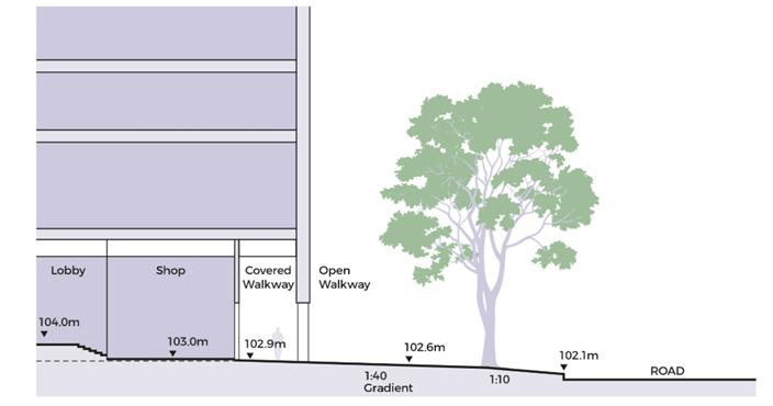
Open walkways below the Minimum Platform Level
The minimum width of the covered walkway is to be 3.6m as shown on Appendix 3. Where colonnades are provided, the internal clear width of the covered walkway is to be minimum 3.0m. For the street block of 250 to 220 Orchard Road and other stretches assessed to have high pedestrian traffic, a wider width of 5.0m (clear width of 4.4m) will be required. To provide adequate protection for pedestrians during inclement weather, the external soffit heights are to minimally match the width of the covered walkway.
To maintain a distinct precinct character, all covered and open walkways are to be predominantly paved in flamed-finish heavy duty grey granite tiles, laid parallel to the Road Reserve to match the existing paving along the Pedestrian Mall.
For more information on the paving requirements, please refer to Annex D [PDF, 1.21 MB].
Through-Block Links
Selected developments, especially those with long frontages, are required to provide through-block links to improve permeability of the street block and in particular, towards the pedestrian mall. Specific design requirements have been imposed on some key sites, depending on the locations of these through-block links.
The minimum width of through-block links is 4.0m to 7.0m, unless otherwise specified. The minimum height of through-block links for Orchard is 10.0m.
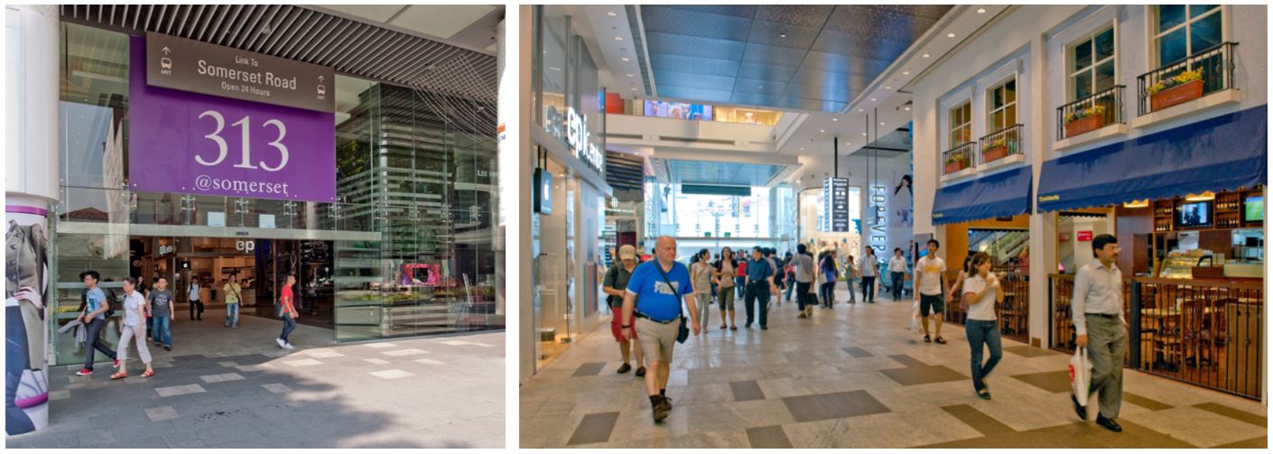
Through block link at 313@Somerset, connecting the Somerset MRT station to Orchard Road.
Underground Pedestrian Network (UPN)
The Underground Pedestrian Network (UPN) complements the 1st storey pedestrian network and provides direct connection to Rapid Transit System (RTS) stations. As a guide, the UPN is to be at least 6.0m wide (with Activity-Generating Uses [AGUs] on one side) or 7.0m (with AGUs on both sides) with a minimum 4.0m (clear) internal ceiling height of the walkway, unless otherwise specified.
UPN is to include vertical pedestrian circulation points within the building envelope to connect to the covered walkway at the 1st storey. Each vertical circulation point is to include a pair of two-way escalators, staircases, and two passenger lifts. The entire UPN and the associated vertical circulation points are to be kept open for public access during the opening hours of the RTS, unless otherwise specified.
Elevated Pedestrian Network (EPN)
The EPN complements the at-grade and underground pedestrian network to provide seamless connectivity between developments. Building owners and developers are encouraged to provide elevated links to connect between buildings.
EPN is to include vertical pedestrian circulation points within the building envelope to link to the covered walkways at the 1st storey. The entire EPN and the associated vertical circulation points are to remain open for the duration of the mall’s operating hours.
For more information, please refer to Annex E [PDF, 276.35 KB].
Uses at the Basement, 1st and 2nd Storey Levels
To create vibrant precincts, attractive and pedestrian-friendly streets, Activity-Generating Uses (AGU), such as retail, food and beverage (F&B), and other active uses are to be provided at the following locations:
The 1st storey of developments fronting key pedestrian malls, side streets and public spaces; and
Alongside the underground pedestrian links at the basement levels of the developments.
AGUs are also encouraged alongside 2nd storey pedestrian links.
For more information on AGUs, please refer to the Development Control Handbook.
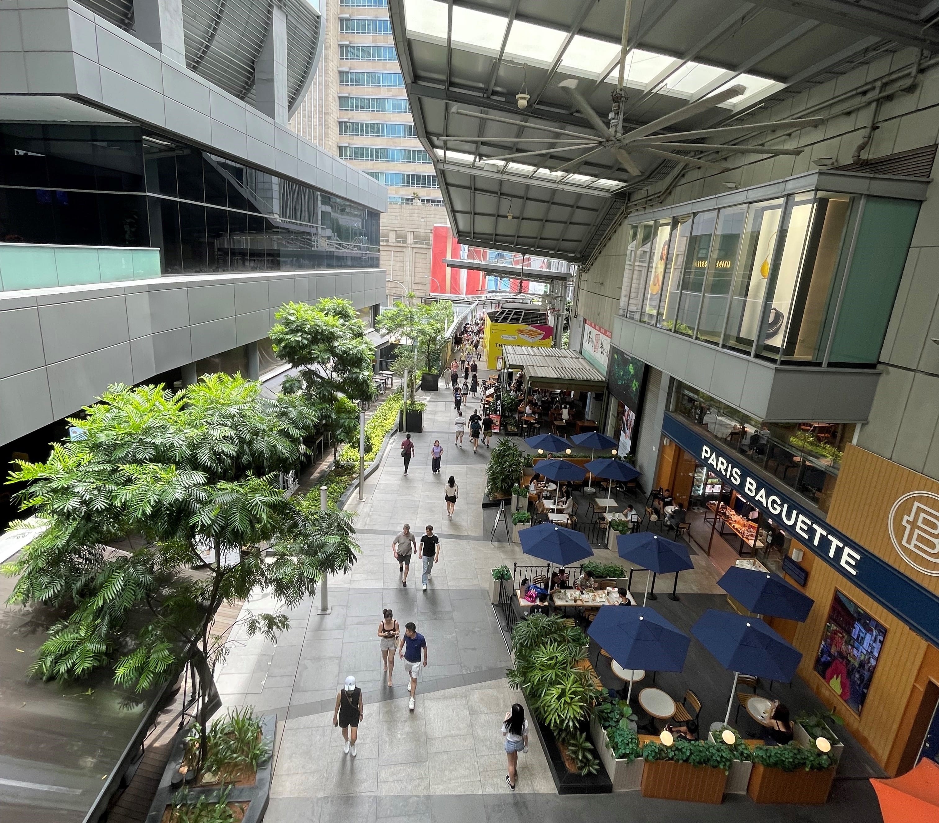
AGUs provided along Discovery Walk.
Outdoor Refreshment Areas
Outdoor Refreshment Areas (ORA), and Outdoor Kiosks are encouraged at the 1st storey directly fronting onto the pedestrian mall, as well as within courtyards and open plazas of the private development sites that are adjacent to the public pedestrian network. The scale and design of the ORA and its structures (if any) are to complement the adjacent building.
Developers are encouraged to incorporate spaces for ORAs at the design stage. The ORAs are to be clearly defined to prevent encroachment onto the adjacent pedestrian thoroughfares e.g. through the use of different floor finishes or planters, etc.
For more information, please refer to Annex A [PDF, 1.35 MB].
Public Space
It is important to provide public spaces within private developments for users to enjoy.
Selected developments along Orchard Road are to provide public open spaces within the development site to support activities that can contribute to the vibrancy of the street. These may be well-landscaped open spaces or covered public spaces that provide a high degree of visual and physical porosity.
These public spaces are to be designed to be conducive for the staging of events and be publicly accessible at all times. They are to be connected to key pedestrian routes at the 1st storey (such as the pedestrian mall, adjacent open and covered walkways, and through-block links). Where applicable, they are to be linked and easily accessible from the underground and/or elevated pedestrian networks within the development.
The design of these public spaces shall comply with the Design Guidelines for Privately Owned Public Spaces (POPS).
An example of a sheltered public space with direct access to the MRT and Underground Pedestrian Network.
Infrastructure & Streetscape
Works within the Road Reserves
To achieve a pedestrian-friendly and consistent district character, all new developments or developments undergoing major Additions and Alterations fronting the pedestrian mall may be required to include the upgrading of the existing pedestrian mall as part of the works. The key elements to consider are tree planting and landscaping, paving materials, pedestrian walkways etc.
Open Walkway
As a guide, the open walkways within the Road Reserve are safeguarded for pedestrian use and to match the paving requirements of the covered walkways. The paving pattern of the open walkways is to be coordinated with the covered walkways and the existing paving pattern along the Pedestrian Mall.
For more information on the paving requirements, please refer to Annex D [PDF, 1.21 MB].
Dedicated Cycling Routes
Certain key roads within the Orchard Planning Area will be earmarked as dedicated cycling routes. The alignment, width and design of the cycling routes and associated street furniture are to be coordinated with URA and LTA.
For more information, please refer to the Special Detailed Control Plan: Connectivity Plan.
Tree and Shrub Planting Specifications
Any new tree or shrub planting specifications for the planting verge within the adjacent Road Reserve will be subject to URA and NParks’ requirements and approval.
Connection to Commuter Facilities
For developments with commuter facilities (e.g. bus stops and taxi stands) located in front of their buildings, sheltered linkways are to be provided between the covered walkways at the 1st storey to these facilities to provide direct continuous sheltered connections.
Servicing, Vehicular Access and Car Parks
To maintain an attractive streetscape, any above-grade car park and service areas, including refuse bin centre(s), loading / unloading bays and vehicular storage lane(s) are to be located away from the pedestrian mall, fully integrated within the overall building form, and visually well-screened from above and on all sides.
Electrical substation(s), where required, can be located at-grade but are to be well-integrated as part of the overall building design and are not to front onto the main roads, pedestrian malls, or public spaces.
All vehicular ingress / egress to car parks, service areas, passenger drop-off / pick-up points and taxi lay-bys, etc, including external ramps, all associated structures and fixtures, are to be located away from the pedestrian mall and well-integrated with the building form and overall architectural treatment of the development. Sufficient holding bays for the vehicular access points to the car parks and service areas are to be provided within the development to ensure the smooth flow of vehicles along adjacent roads.
All car parks are not to front the pedestrian mall, to create a seamless and pedestrian-friendly mall that is uninterrupted by vehicles. Developments fronting the pedestrian mall are encouraged to provide basement car parks. Where there are technical / site constraints, any above-grade car parks are to be located away from promenade and open space, and to be set back from the facade to provide active uses (retail, F&B etc) fronting onto the pedestrian mall. Where the site configuration does not allow for active uses to be incorporated, the facade of the car parking floors is to be designed to match the rest of the building.
Before and After: Transformation of driveway in front of Mandarin Hotel into Pedestrian Mall.
Night Lighting
All commercial developments are strongly encouraged to have a well-designed night lighting scheme that expresses the architectural design and building form when seen from the pedestrian mall and street level, to contribute to the vibrancy and variety of the streetscape.
Creative Hoarding
Where required, developments shall provide Creative Hoarding at construction sites to enhance the streetscape and create a more attractive and vibrant environment. The hoarding may incorporate commissioned artworks, community-produced graphics, or vertical greenery such as creepers and green walls. Where vertical greenery cannot be accommodated, large-scale photographic decals of greenery may be used as an alternative.
Creative Hoarding shall be installed along key frontages of the development, i.e. fronting main streets and pedestrian routes. A minimum of 75% of the required creative hoarding length shall be covered with artwork or greenery.
For more information, please refer to the Creative Hoarding Guide.
Resources
Annexes & Appendices
Annex B: Guidelines on Façade Articulation for Developments in Orchard Planning Area [PDF, 1.68 MB]
Annex D: Orchard Road Mall Paving Design Guidelines [PDF, 1.21 MB]
Appendix 3: 1st Storey Pedestrian Network and Activity-Generating Uses Plan
Appendix 4: Underground Pedestrian Network and Activity-Generating Uses Plan
Appendix 5: Elevated Pedestrian Network and Activity-Generating Uses Plan
Relevant Guidelines & Circulars
Updated Urban Design Guidelines and Plans for Urban Design Areas
Restrictions On The Strata Subdivision of Commercial Properties
Screening of Mechanical and Electrical Services and Car Parks
Guidelines to Encourage More Innovative and Better Design of Rooftop
Update to the Design Guidelines for Privately Owned Public Spaces (POPS)