
Museum
Museum Planning Area offers a wide range of lifestyle amenities like shops, restaurants, cinemas, theatres and other performance venues. As part of the Civic District, it has a rich history, with many art and cultural facilities like The Peranakan Museum and the National Museum of Singapore. Urban design guidelines focus on developing the area to become an institutional hub and ‘Green Lung’ of the Central Area, home to the historic Fort Canning Park.
Last updated 17 June 2026
These urban design guidelines aim to guide the physical development of the area to ensure that individual buildings contribute to, and strengthen the planning vision for the respective zones and create an attractive and pedestrian-friendly physical environment.
Innovative designs that do not fully conform to the guidelines or standard building typologies, but are able to achieve the planning objective relevant to the requirement can be considered, subject to URA’s evaluation of the detailed proposal.
Gazetted monuments and conserved buildings are subject to specific preservation and conservation guidelines respectively, which will take precedence over the guidelines below.
Broad Positioning & Land Use
The following section is to be read together with the following plans:
Envisioned as an institutional hub and the ‘green lung’ of the Central Area, the planning area is set amidst ample green open public spaces and parks.
The planning area features a mix of uses and building types, offering commercial, residential, arts and cultural as well as educational uses. Larger scale commercial developments are predominantly located around the Dhoby Ghaut MRT station, while smaller scale Civic and Community Institution uses (many of which are heritage buildings) are predominantly located on and around Fort Canning Park.
The Urban Design Guidelines for Museum Planning Area aim to achieve:
An Attractive and Unique Streetscape
Sensitive design of the building forms and scale is important to complement and reinforce the greenery, civic and heritage characters of the area.A Pedestrian-Friendly District
Connectivity between major developments, parks and open spaces, and MRT stations via a comprehensive network of walkways, through-block links, and underground pedestrian links in between buildings, will make a more walkable district. For the larger-scale developments, permeability at the ground level is important to allow pedestrians to walk through the buildings.
Building Form & Massing
The following section is to be read together with the following plans:
The building form and massing have to consider how the building will be viewed as well as impact views from major approaches and key open spaces, such as Fort Canning Park.
Developments are not permitted within the safeguarded view corridors
between the Former Saint Joseph's Institution and National Museum of Singapore;
between Singapore Management University (SMU) Green and Cathedral of Good Shepherd; and
between The Cathay and Orchard Road Presbyterian Church.
Consideration is to be given to the scale, form and architectural expression of the surrounding buildings many of which are gazetted heritage buildings.
For developments with building form requirements, alternative configurations of the greenery provisions can be considered, subject to relevant agencies’ approval.
Building Height
Different building heights are specified to respond to the context and to reinforce the character of the district. In general, the overall building height steps down towards Fort Canning Park to retain a lower-rise character around the hill.
The maximum allowable building height is subject to the prevailing Master Plan controls and technical height controls imposed by the technical agencies. Urban Design height controls will take precedence over technical height controls, whichever is lower.
Building Setback and Building Edge
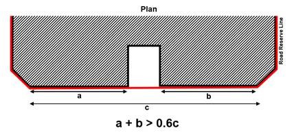
Developments around the Dhoby Ghaut MRT Station - Orchard Road, Penang Road, Handy Road and Clemenceau Avenue - as well as along Hill Street are to be built up to the lines of Road Reserve for minimum 2-storey high to provide a well-defined streetscape.
Up to 40% per building frontage, between the corners of the development, can be set back from the lines of Road Reserve / building setback lines if applicable, for articulation of the building form.
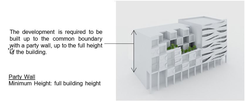
Party Wall Developments
Selected developments are to be built up to abut the common boundary of the development to create party wall developments. This allows developments to maximise the building footprint and creates a continuous pedestrian walkway between developments.
Window openings are not permitted along the party wall.
Guidelines for Commercial Street Block
Party wall developments are to be built up to the common boundary, up to the full height of the building.
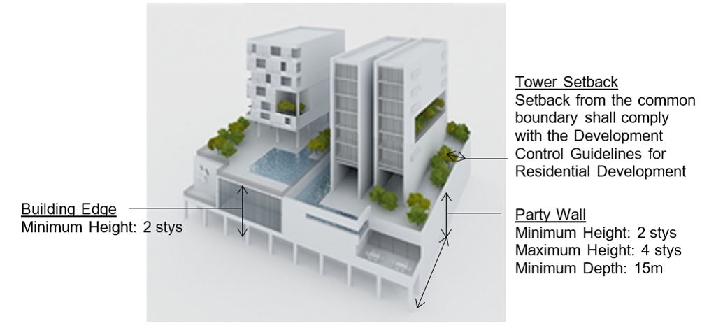
Guidelines for Handy Road Street Block
Party wall developments are to be built up to the common boundary up to a minimum of 2 storeys and not exceeding 4 storeys, and up to a minimum depth of 15m. Beyond the height and depth of the required party wall, the building is to be set back from the common boundary according to the Development Control Guidelines for Residential Developments. This allows for more window openings in the residential developments.
Roofscape
The roof areas are to be considered as the “fifth” elevation and designed to complement the overall form, massing and architectural treatment of each development. The roofs can be designed to be usable outdoor spaces.
All service areas, car parks, Mechanical and Electrical (M&E) equipment, water tanks, etc, are to be fully integrated within the overall building envelope and visually well-screened from the top and on all sides.
For more information, please refer to Screening of Mechanical and Electrical Services and Car Parks and Guidelines to Encourage More Innovative and Better Design of Rooftop (Part A. Relaxation of the Gross Floor Area (GFA) Exemption Guidelines for Rooftop Covers)
Greenery Replacement and Landscaping
To create a green and sustainable city, all new developments will be required to incorporate landscaping in the form of sky terraces and roof gardens according to the Landscape Replacement Area (LRA) requirements.
For more information, please refer to the Development Control Handbook.
Connectivity & Active Uses
The following section is to be read together with the following plans:
The Museum Planning Area is planned as a pedestrian-friendly area with a comprehensive pedestrian network at the 1st storey and basement. This network provides convenient, comfortable and seamless connections between developments, transport facilities, key spaces and attractions, and ensures all-weather comfort. The pedestrian network on all levels is to be designed for universal access.
The pedestrian network on all levels is to be designed for universal access. GFA exemption can be considered for public spaces, covered walkways, through-block links and elevated walkways, subject to the prevailing Development Control Guidelines.
Covered Walkways At-Grade
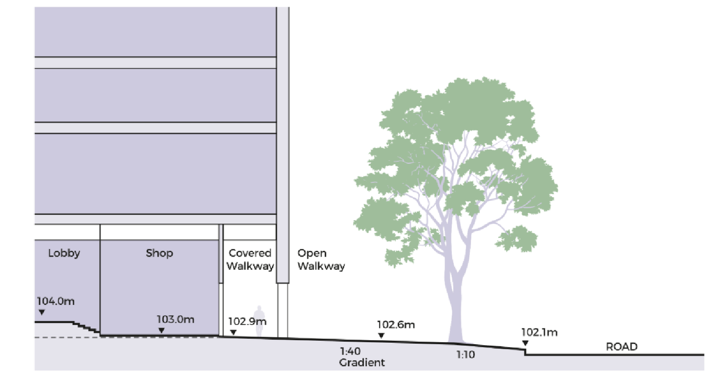
All developments are to provide covered walkways. Where building edge is required, the covered walkway is to abut the Road Reserve or building setback line. Along other streets, the covered walkway can be set back from the line of Road Reserve, following the articulation of the building form. The covered walkways function as public amenities. They are to be kept free of obstruction at all times.
The platform level of the open and covered walkways is to correspond with the adjacent road as far as possible. For open walkways that are below the minimum platform level, the covered walkways may be allowed below the minimum platform level so that they match the platform level of the open walkways. Any difference in levels between the internal platform level of the 1st storey and the covered walkway are to be mediated within the 1st storey of the development and not along the open walkways / covered walkways/linkways.
Open walkways below the Minimum Platform Level
The covered walkway is to be minimally 3.6m wide, unless otherwise specified. Where colonnades are provided, the internal clear width of the covered walkway is to be minimally 3.0m wide. To provide adequate weather protection to pedestrians during inclement weather, the external soffit heights are to minimally match the width of the covered walkway.
To achieve a distinct character within the Civic District (see Appendix 5), the open walkways along identified streets are to be paved in predominantly 600mm x 600mm flamed finish heavy duty Rossa Porrino (or equivalent) granite tiles, set out perpendicular to the lines of Road Reserve. The remaining walkways are to be paved in predominantly 600mm x 600mm flamed finish heavy duty grey-green granite tiles, set out perpendicular to the lines of Road Reserve. The paving pattern of the open walkways is to be coordinated with the covered walkways.
Through Block Links
Selected developments are required to provide through-block links to improve permeability and accessibility at the street level. A network of through-block links has been planned to improve access towards Fort Canning Park and Mount Sophia Residence area.
The minimum width of through-block links is 4.0m to 7.0m, unless otherwise specified.
Underground Pedestrian Network (UPN)
The Underground Pedestrian Network (UPN) complements the 1st storey pedestrian network and provides direct connection to Rapid Transit System (RTS) stations. As a guide, the UPNs are to be at least 6.0m wide (with AGUs on one side) or 7.0m (with AGUs on both sides) with a minimum 4.0m (clear) internal ceiling height of the walkway, unless otherwise specified.
UPNs are to include vertical pedestrian circulation points within the building envelope to connect to the covered walkway at the 1st storey. Each vertical circulation point is to include a pair of two-way escalators, staircases, and two passenger lifts. The entire UPN and the associated vertical circulation points are to be kept open for public access during the opening hours of the RTS, unless otherwise specified.
Uses at the Basement and 1st Storey Level
To create vibrant precincts, attractive and pedestrian-friendly streets, Activity-Generating Uses (AGU), such as retail, food and beverage, and other active uses are to be provided at the following locations:
The 1st storey of developments along Orchard Road as a continuation of the retail experience on Orchard Road; and
Alongside the underground pedestrian walkways at the basement levels of the developments.
For more information on AGUs, please refer to the Development Control Handbook.
Outdoor Refreshment Areas
Outdoor Refreshment Areas (ORA) can be considered within the public areas or open spaces of the private development sites. The scale and design of the ORA and its structures (if any) are to complement the adjacent building. They can only be considered as an extension of an adjoining indoor F&B unit and are for seating only.
If provided, the Gross Floor Area (GFA) for the ORAs are to be computed as part of the maximum permissible GFA for the development, unless otherwise permitted under prevailing bonus GFA schemes.
The ORAs will be subject to the prevailing Development Control Guidelines issued by the Competent Authority under the Planning Act.
Developers are encouraged to incorporate spaces for ORAs at the design stage. The ORAs are to be clearly defined to prevent encroachment onto the adjacent pedestrian thoroughfares e.g. through the use of different floor finishes or planters, etc.
Public Space
It is important to provide public spaces within private developments for users to enjoy.
Selected developments fronting key pedestrian malls and nodes are required to provide public open spaces within the development site so as to provide visual relief, safeguarded views, and public space for gatherings and events. These may be well-landscaped open spaces or covered public spaces that provide a high degree of visual and physical porosity through the building.
Public spaces are to be publicly accessible at all times. They are to be connected to key pedestrian routes at the 1st storey (such as pedestrian malls and promenades, adjacent open and covered walkways, and through-block links), and where applicable, are to be linked and designed to be well-integrated and easily accessible from the underground and elevated 2nd storey pedestrian networks within the development.
The design of these public spaces shall comply with the Design Guidelines for Privately Owned Public Spaces (POPS).
Infrastructure & Streetscape
The following section is to be read together with the following plans:
Works within the Road Reserves
Open Walkway
As a guide, the open walkway within the Road Reserve is safeguarded for pedestrian use and to match the paving requirements of the covered walkways. The paving pattern of the open walkways is to be coordinated with the covered walkways.
Please refer to Appendix 5: Civic District Paving Guidelines for streets with paving requirements.
Connection to Commuter Facilities
For developments with commuter facilities (e.g. bus stop and taxi stands) located in front of their buildings, sheltered linkways are to be provided between the covered walkways at the 1st storey to these facilities to provide direct continuous sheltered connections.
Dedicated Cycling Routes
Certain key roads within the Museum Planning Area will be earmarked as dedicated cycling routes. The alignment, width and design of the cycling routes and associated street furniture are to be coordinated with URA and LTA.
For more information, please refer to the Special Detailed Control Plan: Connectivity Plan.
Servicing, Vehicular Access and Car Parks
To maintain an attractive streetscape, any above-grade car park and service areas, including refuse bin centre(s), loading/unloading bays and vehicle ingress/ egress, storage lane(s), and lay-bys, etc are to be fully integrated within the overall building form, and visually well-screened from above and on all sides. Electrical substation(s), where required, can be located at-grade but are not to front onto the main roads, pedestrian malls, or public spaces.
Sufficient holding bays for the vehicular access points to the car parks and service areas are to be provided within the development to ensure the smooth flow of vehicles along adjacent roads.
For more information, please refer to Screening of Mechanical and Electrical Services and Car Parks and Guidelines to Encourage More Innovative and Better Design of Rooftops (Part A. Relaxation of the Gross Floor Area (GFA) Exemption Guidelines for Rooftop Covers)
Night Lighting
All developments within the Civic District are to provide night lighting to enhance the district character at night.
For more information, please refer to the Revision to the Night Lighting Guidelines for Developments in the Central Business District (CBD), Civic District, Marina Bay and Marina Centre.
Creative Hoarding
Where required, developments shall provide Creative Hoarding at construction sites to enhance the streetscape and create a more attractive and vibrant environment. The hoarding may incorporate commissioned artworks, community-produced graphics, or vertical greenery such as creepers and green walls. Where vertical greenery cannot be accommodated, large-scale photographic decals of greenery may be used as an alternative.
Creative Hoarding shall be installed along key frontages of the development, i.e. fronting main streets and pedestrian routes. A minimum of 75% of the required creative hoarding length shall be covered with artwork or greenery.
For more information, please refer to the Creative Hoarding Guide.
Resources
Annexes & Appendices
Relevant Guidelines and Plans
Updated Urban Design Guidelines and Plans for Urban Design Areas
Restrictions On The Strata Subdivision of Commercial Properties
Screening of Mechanical and Electrical Services and Car Parks
Guidelines to Encourage More Innovative and Better Design of Rooftop
Update to the Design Guidelines for Privately Owned Public Spaces (POPS)