
Funtastic Gems in the Central Region
From sporting facilities to heritage and community nodes, find out more about the various recreational spaces coming your way in Singapore's Central Region.
Last updated 5 June 2026
Endless possibilities for all
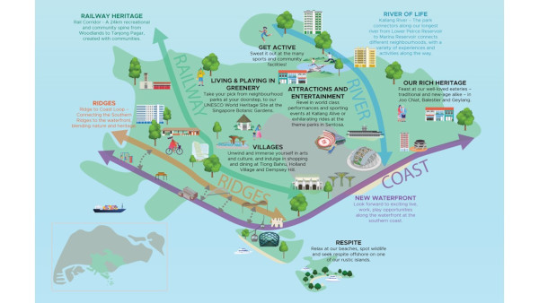
The region is home to Singapore’s national stadium at Kallang, the Rail Corridor, and Kallang River, Singapore’s longest river. Characterised by these rich green, blue and heritage assets amidst established and new housing areas, there are endless recreational options for all!
Click on each photo to find out more about the various recreational spaces coming your way in the Central Region!

Join us in re-imagining these places
Home for sports
Kallang Alive
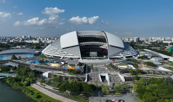
Waterfront Area at the Sports Hub. Photo Credit: Sport Singapore
The Kallang Alive precinct is envisioned to be a world-class destination for sports, leisure, and entertainment, with a new indoor arena that will be among the best-in-class globally. The precinct will also be transformed into an endearing community space where all Singaporeans can meet and bond with one another through sport and community activities.
Farrer Park
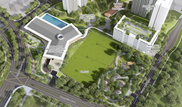
Artist’s impression of the upcoming neighbourhood park, playfield, swimming complex in front of the new housing estate. Photo Credit: Sport Singapore
From being Singapore’s first racecourse in the 1800s to the home of our national athletes from the late 1950s, Farrer Park is well remembered for its long sporting history. To recall its rich sporting heritage, the redeveloped public housing estate will include a wide array of sports and recreational facilities such as a new swimming complex with sheltered pool, multipurpose playfield, and gym, etc.
Kallang River
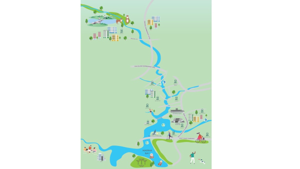
With a length of 10 kilometres starting from Lower Peirce Reservoir to Marina Reservoir, Kallang River is Singapore’s longest river and a key blue recreational corridor for cycling, jogging, kayaking, and many more.
Repurposing the former Kallang Airport for recreation
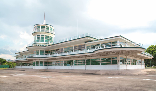
Old Kallang Airport Terminal Building. Photo Credit: Singapore Land Authority
Built in the 1930s, the Kallang Airport is Singapore’s first purpose-built civil international airport. Selected buildings and structures have been conserved to remind us of our aviation history and the airport's role in establishing Singapore’s position on the international aviation map.
Bishan-to-City (B2C) crossings
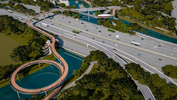
Artist’s impression of the upcoming PIE crossing
The upgraded crossings along the Bishan-to-City Link will improve the accessibility along Kallang River at locations previously cut-off by major roads and bridges. This will allow residents to seamlessly walk, jog or cycle from the Bishan-Ang Mo Kio Park to the Kallang Basin and the city. As of 2023, works for four underpasses (including the CTE underpass), three surface road crossings and the Braddell cycling bridge have been completed. Further improvement works that will be completed by 2027 include a new pedestrian/cyclist bridge across the PIE.
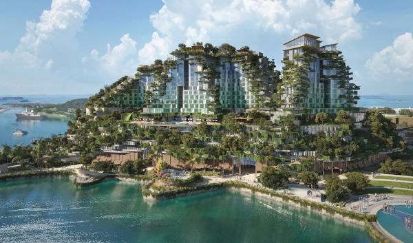
Island playground and sanctuary at Greater Sentosa
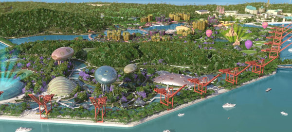
Artist's impression of possibilities for Pulau Brani under the Greater Sentosa Master Plan (formerly known as Sentosa-Brani Master Plan). Photo credit: Sentosa Development Corporation
Sentosa is envisioned as a game-changing leisure destination of the future while Pulau Brani is intended to host new tourism attractions. Leveraging their island charm, ridge-to-reef connection and proximity to the city, the rejuvenated islands will boast a broad spectrum of leisure offerings including world class attractions, reimagined beach experiences as well as expanded nature and heritage trails.
Sentosa's heritage trails
Barracks Hotel. Photo Credit: National Heritage Board
Have you explored Sentosa’s forts and artillery batteries, former British military barracks and stately bungalows? Sentosa Development Corporation and National Heritage Board have curated three thematic heritage trails to showcase Sentosa’s long history from when it was known as Pulau Blakang Mati in the 17th Century.
Sentosa Sensoryscape
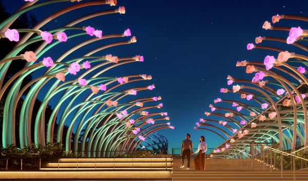
Glow Garden. Photo Credit: Sentosa Development Corporation
To kickstart rejuvenation plans on Sentosa, Sentosa Development Corporation launched Sentosa Sensoryscape in March 2024. Reconnect with your senses as you take a seamless journey from ridge to reef and experience a myriad of sensorial delights both day and night.
Resorts World Sentosa's phase 2 expansion
Artist's impression of RWS 2.0. Photo Credit: Resorts World Sentosa
This upcoming waterfront development at Sentosa’s doorstep will feature new experiential lifestyle offerings and an iconic public attraction along the waterfront. New green recreational trails, vantage points and activated promenade spaces can also be added to enrich visitor experience.
Island playground and sanctuary at Southern Islands

The Southern Islands comprise eight smaller islands off Sentosa. Can you name them? Today, the islands offer a tranquil retreat from the hustle and bustle of city living, with beaches, trails, coastlines and island heritage for you to explore.
Ecotourism
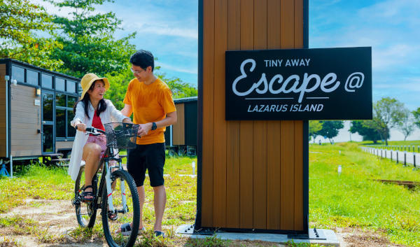
Tiny Homes. Photo Credit: Tiny Away Escape
Sentosa Development Corporation recently launched a curated list of light-touch ecotourism and leisure initiatives on parts of the Southern Islands for the public to escape from the city and get active.
New marine park
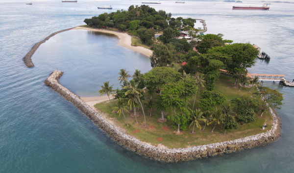
Kusu Reef. Photo Credit: National Parks Board
The Southern Islands comprises ecologically significant marine habitats in Singapore, including coral reefs and rocky shores. Singapore’s first marine park, the Sisters’ Islands Marine Park, was established in 2014 and plans to designate a second marine park at Lazarus South – Kusu Reef were recently unveiled. This pair of marine parks will not only strengthen marine and terrestrial conservation, but it will also provide opportunities for nature-based recreation.
Rail Corridor
.jpg)
The Rail Corridor is a 24 km-long green recreational spine. It threads through diverse communities and connects residents, workers and visitors from all walks of life. In fact, approximately 1 million people live within 1 km of the Rail Corridor! Today, visitors can enjoy over 21 km of continuous connectivity along the Rail Corridor from Kranji MRT station to Spooner Road, and four community nodes at Kranji, the PIE viaduct, former Bukit Timah Railway Station and Buona Vista.
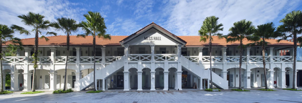
Buona Vista Node
Newly opened Buona Vista Node
Opened in April 2024, the Buona Vista Node offers inclusive spaces for play and community and cultural events. Residents and visitors to the Rail Corridor can enjoy new facilities such as a children’s playground with biophilic elements, fitness areas for adults and seniors, and a community lawn that serves as a flexible events space.
'From Dreams to Rail-ity': ideas competition for the former Tanjong Pagar Railway Station

Former Tanjong Pagar Railway Station
URA launched the ‘From Dreams to Rail-ity’ Ideas Competition (22 April to 14 June 2024) for the former Tanjong Pagar Railway Station to invite ideas from the public to transform it into a vibrant, multi-functional community building with attractive, inclusive and inviting public spaces for all to enjoy and appreciate the unique heritage of the site. Ideas from the competition will help to guide the plans for the site in the future.
Queensway Node
.jpg)
Artist’s impression of flexible community space under Queensway viaduct
Located in the heart of Queenstown, the Queensway node is surrounded by existing and upcoming residential neighbourhoods at Tanglin Halt, Mei Chin and Queensway. The Queensway viaduct crosses above the Rail Corridor, creating an expansive and fully sheltered space. It can be transformed into a multi-functional community node. Residents and the community hope to see a safe, accessible, comfortable, vibrant, and flexible space that can be used for a variety of activities.
Ridge to Coast Loop
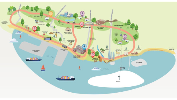
The Southern Ridges, comprising Mount Faber Park, Telok Blangah Hill Park, HortPark and Kent Ridge Park, is an established and well-loved recreational destination linked by two iconic bridges, the Henderson Waves and Alexandra Arch. There is potential to extend the connectivity of the ridgeline west of Kent Ridge Park and curate a loop from the ridges to the foothills and the waterfront.
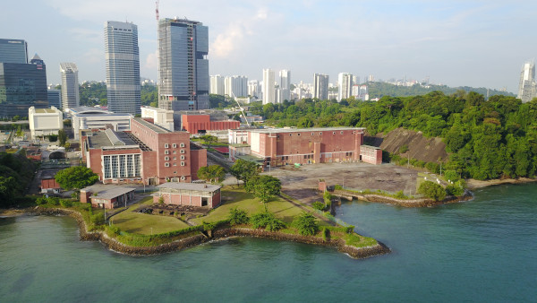
1. Kent Ridge
5 Kent Ridge Road
Did you know that settlers used to grow crops including rubber and pineapple on the ridge? The ridge was also used as a fortress by the British and witnessed several fierce battles in the defense of Singapore in World War II. Apart from Kent Ridge Park which is popular among families, photographers, fitness and mountain biking enthusiasts, there is a lesser-known half of Kent Ridge located within the National University of Singapore’s campus. Besides offering panoramic views of the waterfront, the area also hosts numerous World War II heritage sites for history buffs to explore.
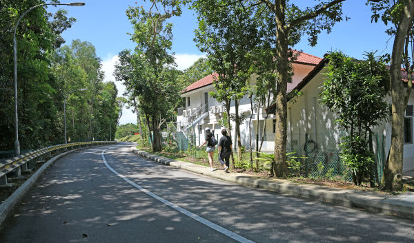
2. Mount Faber Mid-hills and Alexandra Park
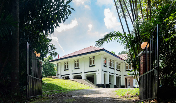
6 Hyderabad Road. Photo Credit: Singapore Land Authority
The area features a collection of colonial bungalows built between the early 1900s and World War II that represent different architectural forms, amidst lush greenery. How can these buildings be repurposed for the public to explore and enjoy?
3. Parks along the Southern Ridges and West Coast
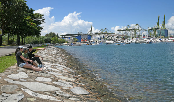
West Coast Park
The National Parks Board (NParks) plans to enhance and connect 13 southwestern parks to the islandwide Park Connector Network and Round Island Route via curated trails, further extending the recreational opportunities in the Central Region. These plans include enhancing HortPark, Labrador Nature Park and West Coast Park into Destination Parks with thematic identities.
4. Waterfront at Pasir Panjang Power District
Pasir Panjang Power District
The former industrial waterfront with two iconic former power station buildings can be transformed into a vibrant activity node, seamlessly blending recreation, nature and heritage!