
Woodlands Regional Centre
Woodlands Regional Centre (WRC) is the economic hub of Singapore’s Northern Gateway and will leverage enhanced connections to other parts of Singapore and Johor Bahru, as well as the Johor-Singapore Special Economic Zone (SEZ).
Last updated 23 June 2026
Woodlands Central is one of the four precincts within Woodlands Regional Centre (WRC), and is the main commercial hub of the North region, with more office and retail spaces to be developed in the future to cater to the needs of businesses and residents.
These urban design guidelines aim to guide the physical development of the area to ensure that individual buildings contribute to, and strengthen the planning vision for the respective zones and create an attractive and pedestrian-friendly physical environment.
Innovative designs that do not fully conform to the guidelines or standard building typologies, but are able to achieve the planning objective relevant to the requirement can be considered, subject to URA’s evaluation of the detailed proposal.
Gazetted monuments and conserved buildings are subject to specific preservation and conservation guidelines respectively, which will take precedence over the guidelines below.
Broad Positioning & Land Use
The following section is to be read together with the following plans:
Woodlands Regional Centre (WRC) is the economic hub of Singapore’s Northern Gateway and will leverage enhanced connections to other parts of Singapore and Johor Bahru, as well as the Johor-Singapore Special Economic Zone (SEZ).
WRC is seamlessly connected to key locations in Singapore and Johor Bahru via rail and road. The Woodlands Integrated Transport hub with both the North-South and Thomson-East Coast MRT Lines is in Woodlands Central, with a multi-modal transport hub to be developed at Woodlands Gateway. It will also benefit from enhanced cross border connectivity via the redeveloped Woodlands Checkpoint and upcoming Johor Bahru – Singapore Rapid Transit System Link (JB-SG RTS Link). This provides unique opportunities for businesses looking to set up a base to support their regional operations.
To provide these opportunities, WRC will offer a diverse mix of office, retail, and industrial spaces across four precincts, in addition to residential and community uses. The area is envisioned to feature a seamless and integrated pedestrian network with well-designed public realms to support a diversity of users – from residents and commuters to industrial workers and visitors – creating a delightful, inclusive, and people-centric environment with a sense of place and identity.
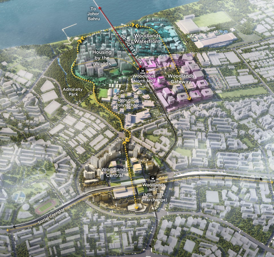
Woodlands Central
Woodlands Central, one of the four precincts within Woodlands Regional Centre (WRC), will be the core node for office and retail spaces in the North, catering to the needs of businesses and residents. Woodlands Central is envisioned as a pedestrian-centric hub, with sheltered pedestrian networks at multiple levels providing connections between developments, transport facilities, public spaces and cycling paths.
Woodlands Gateway
Positioned as a vibrant employment and manufacturing hub, this precinct leverages its direct connection to the Johor Bahru – Singapore Rapid Transit System Link (RTS) station, transforming it into a vibrant and welcoming node for visitors and commuters. It is envisioned as a work-learn-make node geared for clean production and research, a catalyst for next-generation jobs, retail, and business hubs thriving in a future-ready vibrant work environment.
Housing by the Woods
A seamlessly integrated residential and community precinct, blending housing and social amenities with the lush natural environment of Admiralty Park. Residents will have direct access to nature, with an emphasis on wellness and sustainable urban living. The Woods Vista Gallery will be a key feature, an upcoming pedestrian link that provides seamless connectivity to Woodlands Central.
Woodlands Waterfront
Developments here will be designed sensitively given the unique waterfront context, with a variety in housing density and building heights to create a comfortable and welcoming public realm, seamlessly connected to and continuing along Woodlands Waterfront Park.
Building Form & Massing
Building Form
The overall building form and massing of individual buildings is to consider how the building will be viewed, as well as impact views from major approaches and key open spaces.
The design of the building form and massing, together with the architectural treatment, is to consider the scale, form and architectural expression of the surrounding buildings, and be designed to create engaging and varied public spaces. Wall-like developments shall be avoided.
The design of the building form and massing, together with the architectural treatment, is to consider the scale, form and architectural expression of the surrounding buildings, and be designed to create engaging and varied public spaces. Wall-like developments should be avoided.
For developments with building form requirements, alternative configurations of greenery provision can be considered, subject to relevant agencies’ approval.
Building Facades
The building façades of the development fronting all main roads and major public spaces are to be treated as main elevations.
The building facades of the development are to be well-articulated with solid (walls) / void (fenestration) areas that draw upon a combination of different materials (e.g. concrete, brick, steel, glass, greenery, etc.).
To create visual interest and to further break down the building mass, elements of tropical architecture such as sky terraces, balconies, sun-shading louvers, deep recesses, window ledges, roof terraces, communal planter boxes and vertical green walls are to be provided as part of the development and integrated with the overall building form and architectural treatment of the development.
For more information, please refer to Sensitive Design and Development: An Industry Guide of Good Practices to minimize Wall-Like Development.
Building Height
Different building heights are specified to respond to the context and to reinforce the character of the district.
Selected developments may be subject to site-specific building height controls, which will take precedence over technical height controls, whichever is lower.
Building Setback and Building Edge
Woodlands Central is envisioned as a lushly landscaped precinct. In line with this vision, developments within Woodlands Central are to be set back from the boundary to create space for landscaping.
Developments shall comply with the setback requirements in accordance with the prevailing Development Control guidelines. Selected developments may also be subject to site-specific setback controls, which will take precedence over prevailing DC guidelines.
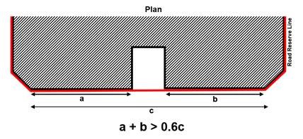
Where applicable, developments are to be built up to the building setback line to create a well-defined urban streetscape. Up to 40% of the length of the building façade, between the corners of the development, can be set back for articulation of the building form.
Roofscape and Screening
The roof areas are to be considered as the “fifth” elevation and designed to complement the overall form, massing and architectural treatment of each development. The roofs can be designed to be usable outdoor spaces.
Screening Requirements
To ensure that the roof areas are well-designed and attractive when viewed from the surrounding developments, all service areas, mechanical and electrical (M&E) equipment, water tanks, etc., are to be located within and fully integrated into the building envelope and be visually well-screened from the top and all sides of the development.
For more information, please refer to Screening of Mechanical and Electrical Services and Car Parks.
Greenery Replacement and Landscaping
To create a green and sustainable city, all new developments will be required to incorporate landscaping in the form of sky terraces and roof gardens according to the Landscape Replacement Area (LRA) requirements, unless otherwise specified.
For more information, please refer to the Development Control Handbook.
Connectivity & Active Uses
The following section is to be read together with the following plans:
Pedestrian Network
Woodlands Central is planned as a pedestrian-friendly area with a comprehensive sheltered network at multiple levels. This network provides convenient, comfortable, and seamless connections between developments, transport facilities, key spaces and attractions, and ensures all-weather comfort.
General Conditions
The pedestrian network on all levels is to be designed for universal access. GFA exemption is applicable for public spaces, covered walkways, through-block links and elevated walkways, subject to the prevailing Development Control Guidelines.
At-Grade Pedestrian Network
The at-grade pedestrian network is augmented by covered walkways that provide all-weather protected pedestrian routes. All developments are required to provide covered walkways at the 1st storey along the site boundaries / lines of Road Reserves or the designated setback lines, unless otherwise specified. The covered walkways function as public amenities. They are to be kept free of obstruction at all times.
The minimum width of the covered walkways is to be 3.6m or 5m. Where colonnades are provided, the internal clear width of the covered walkways is to be minimum 3.0m and 4.4m respectively. To provide adequate protection for pedestrians during inclement weather, the external soffit heights are to minimally match the width of the covered walkway.
Through-Block Links
Selected developments are required to provide through-block links to break down the scale and improve permeability of the streetblock.
Underground Pedestrian Network (UPN)
The UPN complements the 1st storey pedestrian network and provides direct connection to Woodlands Thomson-East Coast Line (TEL) station. As a guide, Underground Pedestrian Links (UPLs)are to be at least 6.0m wide (with AGUs on one side) or 7.0m (with AGUs on both sides) with a minimum 4.0m (clear) internal ceiling height of the walkway, unless otherwise specified.
Vertical pedestrian circulation points are to be included within the building envelope to link the UPN to the covered walkways at the 1st storey or the periphery of the public spaces. Each vertical circulation point is to include a pair of two-way escalators, staircases, and two passenger lifts. The entire UPN and the associated vertical circulation points are to be kept open for public access during the opening hours of the Rail Transit System, unless otherwise specified, and be visible from the at-grade and underground pedestrian network.
Elevated Pedestrian Network (EPN)
The EPN complements the at-grade pedestrian network to provide seamless connectivity between developments. Building owners and developers are required to provide elevated links to connect between buildings.
Vertical pedestrian circulation points are to be included within the building envelope to link the EPN to the covered walkways at the 1st storey or the periphery of the public spaces. Each vertical circulation point is to include a pair of two-way escalators, staircases, and two passenger lifts. Unless otherwise specified, the entire EPN and the associated vertical circulation points are to remain open for the duration of the mall’s developments’ business operating hours, and be visible from the at-grade and elevated pedestrian network.
Uses at the 1st and 2nd Storey Levels
To create vibrant precincts, as well as attractive and pedestrian-friendly streets, activity-generating uses (AGU) such as retail, food and beverage (F&B), and other active uses are to be provided at the 1st storey of developments fronting pedestrian malls, through block links, key streets and public spaces.
For more information on AGUs, please refer to the Development Control Handbook.
Outdoor Refreshment Areas
Where allowed, Outdoor Refreshment Areas (ORA), i.e. outdoor dining areas, can be considered within the public areas or open spaces within private development sites. The scale and design of the ORA and its structures (if any) are to complement the adjacent building. They can only be considered as an extension of an adjoining indoor food and beverage (F&B) unit and are for seating only.
If provided, the Gross Floor Area (GFA) for the ORAs are to be computed as part of the maximum permissible GFA for the development and subject to the prevailing Development Control Guidelines under the Planning Act.
Developers are encouraged to incorporate spaces for ORAs at the design stage. The ORAs are to be clearly defined to prevent encroachment onto the adjacent pedestrian thoroughfares e.g. through the use of different floor finishes or planters, etc.
Public Space
It is important to provide public spaces within private developments for users to enjoy.
Selected developments are required to provide public spaces within the development site. These may be well-landscaped open spaces, or covered public spaces that provide a high degree of visual and physical porosity through the building.
Public spaces are to be publicly accessible at all times. They are to be connected to the key pedestrian routes at the 1st storey (such as open and covered walkways, through-block links, pedestrian malls and promenades), and, where applicable, designed to be well-integrated and easily accessible from the underground and elevated pedestrian networks within the development.
The design of these public spaces shall comply with the Design Guidelines for Privately Owned Public Spaces (POPS).
For more information, please refer to the Update to the Design Guidelines for Privately Owned Public Spaces (POPS).
Infrastructure & Streetscape
Works within Road Reserve
To achieve a consistent district character, all new developments or those undergoing major additions and alterations are required to include the upgrading of the existing roadside tables within the adjacent Road Reserve, as specified below.
Open Walkway
As a guide, open walkways within the Road Reserve are safeguarded for pedestrian use. Any proposed new paving with the Road Reserve will be subject to URA and LTA’s requirements and approval.
Connection to Commuter Facilities
For developments with commuter facilities (e.g. bus stops and taxi stands) located in front of their buildings, sheltered linkways are to be provided between the covered walkways at the 1st storey to these facilities to provide direct continuous sheltered connections.
Dedicated Cycling Routes
Certain key roads within Woodlands Central will be earmarked as dedicated cycling routes (please refer to the Special Detailed Control Plan: Connectivity Plan). The alignment, width and design of the cycling routes and associated street furniture are to be coordinated with URA and LTA.
Tree and Shrub Planting Specifications
Any new tree or shrub planting specifications for the planting verge within the adjacent Road Reserves will be subject to URA and NParks’ requirements and approval.
Servicing, Vehicular Access and Car Parks
All driveways and vehicular accesses are to be located away from public spaces or main pedestrian routes. This is to create a seamless and pedestrian-friendly network that is uninterrupted by vehicles.
To maintain an attractive streetscape, any above-grade car park and service areas, including refuse bin centre(s), loading / unloading bays and vehicle ingress/ egress, storage lane(s), and vehicular drop-offs/ lay-bys, etc. are to be fully integrated within the overall building form, and visually well-screened from above and on all sides. Electrical substation(s), where required, can be located at-grade but are not to front onto the main roads, pedestrian malls, or public spaces.
Sufficient holding bays for the vehicular access points to the car parks and service areas are to be provided within the development to ensure the smooth flow of vehicles along adjacent roads.
For more information, please refer to Screening of Mechanical and Electrical Services and Car Parks.
Night Lighting
Good night lighting can enhance the nightscape and district character. The night lighting scheme shall bring out the key architectural features of the building form, crown, facades, gardens and landscaped areas.
Signage
All developments shall comply with LTA’s signage and wayfinding requirements for Woodlands Central, and submit the signage layout and design to the relevant Authorities for detailed evaluation and approval before Temporary Occupation Permit (TOP) can be issued.
Creative Hoarding
Where required, developments shall provide Creative Hoarding at construction sites to enhance the streetscape and create a more attractive and vibrant environment. The hoarding may incorporate commissioned artworks, community-produced graphics, or vertical greenery such as creepers and green walls. Where vertical greenery cannot be accommodated, large-scale photographic decals of greenery may be used as an alternative
Creative Hoarding shall be installed along the key frontages of the development, i.e. fronting main streets and pedestrian routes. A minimum of 75% of the required creative hoarding length shall be covered with artwork or greenery.
For more information, please refer to the Creative Hoarding Guide.