
Punggol Digital District
The Punggol Digital District (PDD) comprises of the Singapore Institute of Technology (SIT) and business park developments by JTC Corporation (JTC). This district is intended to become a growth cluster for the digital and cyber-security industries. It is envisaged to be a vibrant, well-connected, and sustainable district with close integration of industries, academia, and the community at large.
Last updated 23 June 2026
These urban design guidelines aim to guide the physical development of the area to ensure that individual buildings contribute to, and strengthen the planning vision for the respective zones and create an attractive and pedestrian-friendly physical environment.
Innovative designs that do not fully conform to the guidelines or standard building typologies, but are able to achieve the planning objective relevant to the requirement can be considered, subject to URA’s evaluation of the detailed proposal.
Gazetted monuments and conserved buildings are subject to specific preservation and conservation guidelines respectively, which will take precedence over the guidelines below
Broad Positioning & Land Use
The following section is to be read together with the following plans:
Punggol Digital District (PDD)
The Punggol Digital District (PDD) comprises of the Singapore Institute of Technology (SIT) and business park developments by JTC Corporation (JTC). This district is intended to become a growth cluster for the digital and cyber-security industries. It is envisaged to be a vibrant, well-connected, and sustainable district with close integration of industries, academia, and the community at large.
Planned to be a public transport-oriented, walkable and cycling-friendly district, the developments shall be seamlessly integrated with a comprehensive network of walkways and cycling paths. The developments in this district shall capitalise on the waterfront and lush greenery, while retaining the sense of undulating topography and rustic charm.
The developments shall attain the BCA Green Mark Platinum rating in line with the Public Sector Taking the Lead in Environmental Sustainability (PSTLES) initiative.
Building Form & Massing
The following section is to be read together with the following plans:
Building Form
The building form and massing is to relate sensitively to the existing topography and natural features.
The developments are envisaged to be nestled in a campus-like environment interspersed with lush landscaping, skyrise greenery, pockets of courtyard spaces and passive design elements; and to respond to the tropical climate.
The building form is to consider views to the surrounding, as well as impact on views from major approaches and key open spaces.
Developments shall not form a wall-like effect especially along Heritage Trail, the waterfront and new Punggol Road. They are envisaged to be articulated as a series of smaller scale buildings with high degree of visual and physical porosity towards the Heritage Trail, the waterfront and New Punggol Road.
The scale and the massing for the developments shall be guided by the chart shown in FIG.1. Buildings shall be designed to fall within the Acceptable Zone. In the event that the length of a building exceeds the Acceptable Zone and needs to be articulated as two separate buildings, a minimum distance of 25m shall be maintained between the two buildings.
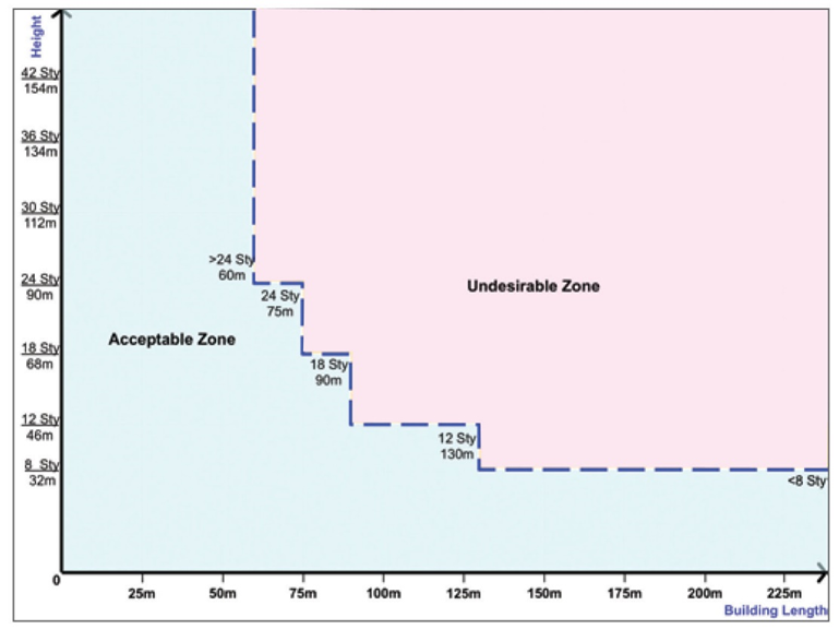
FIG. 1: Chart to guide a comfortable scale and massing for development
Building Facades
The building façades of the development fronting all main roads and major public spaces are to be treated as main elevations.
The building facades of the development are to be well-articulated with solid (walls) / void (fenestration) areas that draw upon a combination of different materials (e.g. concrete, brick, steel, glass, greenery, etc.).
To create visual interest and to further break down the building mass, elements of tropical architecture such as sky terraces, balconies, sun-shading louvers, deep recesses, window ledges, roof terraces, communal planter boxes and vertical green walls are to be provided as part of the development and integrated with the overall building form and architectural treatment of the development.
Building Height
The detailed building height zones are demarcated for the developments in the Urban Design (UD) Guide Plans:
(a) High-rise zone – Up to allowable technical height control;
(b) Low-rise zone –
(i) Fronting the waterfront promenade (within Market Village):
Maximum 1 storey. To retain a more intimate scale along the waterfront promenade, the building height (within a depth of up to 50m wide) shall be kept not higher than single-storey and articulated as a series of discrete buildings or pavilions interspersed among the existing Casuarina trees so as to retain the existing rustic waterfront character. See FIG. 3.
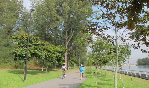
FIG 2: Casuarina trees lining the waterfront along the proposed Market Village
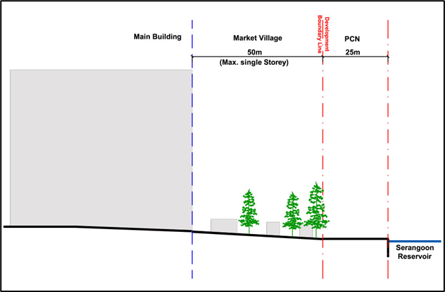
FIG 3: The Market Village with a depth of 50m wide shall be designed in consideration of the need to retain and integrate the existing trees. In addition, a smooth level transition to the lower promenade level shall be designed.
(ii) Fronting the waterfront promenade (outside the Market Village):
Maximum 4 storeys stepping down to single storey towards the waterfront. See FIG. 4.
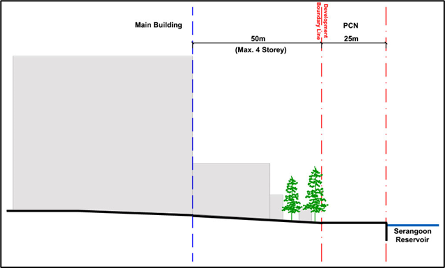
FIG 4: A depth of 50m wide fronting the waterfront promenade shall be kept at a max. 4 storey and shall be designed in consideration of the need to retain and integrate the existing trees. In addition, a smooth level transition to the lower promenade level shall be designed.
(iii) Fronting the Heritage Trail:
Maximum 4 storeys.
(iv) Fronting the low-rise landed housing area:
Maximum 4 storeys.
Building Edge
To provide a well-defined and active street edge along the key pedestrian thoroughfares, developments shall provide a minimum 4-storey high building edge abutting the building setback lines along the Campus Boulevard.
Up to 40% of the length of the building façade, between the corners of the development, can be set back for articulation of the building form.
Building Setback
Developments shall be guided by the following building setbacks as shown in the UD Guide Plans:
(a) Along Campus Boulevard
Developments shall be set back 5m from the Campus Boulevard to create spaces for spill out-activities as an extension of the adjacent developments. Landscaping, seating areas, retail kiosks and outdoor refreshment areas, etc. shall be incorporated within this 5m building setback zone. See Fig. 5.
(b) Along the waterfront promenade
No building setback is required.
(c) Along part of New Punggol Road, Punggol Coast Road and Punggol Close
Developments shall be set back as per URA prevailing Development Control Guidelines from lines of Road Reserve. The building setback area shall be attractively landscaped with an additional row of tree planting to complement the adjoining public pedestrian walkway and greenery (within the Road Reserve).
The landscaped areas within the building setback shall create a lush environment and provide multiple landscaped footpaths between the roadside public walkways and the covered walkways of the development seamlessly.
(d) Along Punggol Way and Sentul Crescent Extension
Developments shall be set back as per URA prevailing Development Control Guidelines from lines of Road Reserve. The area within the building setback is to be lushly planted to achieve a park-like setting in the heart of the Creative Cluster and Learning Corridor, and to accentuate the rustic character enroute to Coney Island via Punggol Way.
The detailed landscaping proposal will be subject to the approval of the Authority and the relevant Competent Authorities at the formal submission stage.
(e) Along Heritage Trail
Developments shall be set back 7.5m from the Heritage Trail park boundary line.
(f) Along Future Road
Developments shall be set back 30m from the line of Road Reserve. The area within the building setback shall be lushly landscaped.
Submerged basement structures can be built up to the common boundary lines and the lines of Road Reserve, provided the portion underneath the green buffer / planting strip is submerged at least 2m or more below the ground level, so as to allow for meaningful tree planting and landscaping.
Roofscape and Screening
The roof areas are to be designed as an integrated part of the overall building form.
Greenery shall be incorporated on the roof areas as much as possible to enhance the rustic and natural charm of Punggol.
Screening Requirements
To ensure that the roof areas are well-designed and attractive when viewed from the surrounding developments, all service areas, mechanical and electrical (M&E) equipment, water tanks, etc., are to be located within and fully integrated into the building envelope and be visually well-screened from the top and all sides of the development.
Solar Panels on Building Rooftops
For any solar photovoltaic (PV) panels installed on the rooftops of buildings of the developments, shall comply with the best practices guide for the installation of solar panels on rooftops.
For more information, please refer to Screening of Mechanical and Electrical Services and Car Parks and Advisory Note on Best Practices for Installing Solar Panels on Building Rooftops.
Greenery Replacement and Landscaping
To create a green and sustainable city, all new developments will be required to incorporate landscaping in the form of sky terraces and roof gardens according to the Landscape Replacement Area (LRA) requirements.
The development on the Land Parcel is required to include Landscape Replacement Areas (LRAs) equivalent in area to 100% of the site area of the Land Parcel.
For more information, please refer to the Development Control Handbook.
Connectivity & Active Uses
The following section is to be read together with the following plans:
Pedestrian Connectivity
The district is envisaged to be well-served by a network of pedestrian walkways at multiple levels that give easy access to the various amenities and transport nodes amid a lush green setting.
Heritage Trail
Old Punggol Road will be preserved as an undulating heritage trail for walking and cycling. This Heritage Trail will connect Punggol Central to Punggol Point at the north. Covering a distance of approximately 1.3km, it will enable the public to enjoy leisurely strolls amidst lush greenery from the Punggol Waterway Park to the Punggol Point Park.
Considerations shall be given to the treatment of the trail where it intersects with the proposed future arterial road between Lorong Halus and Seletar, and other roads at Punggol North, as well as with the Integrated Transport Hub, in order to maintain an uninterrupted green corridor leading to the northern coast.
The south of Heritage Trail will be connected to the Punggol Waterway Park via at grade pedestrian crossing at the future arterial road.
Please consult NParks on the landscape requirements for Heritage Trail.
Campus Boulevard
A minimum 18m wide pedestrian mall (Campus Boulevard) at RL 115 shall be provided as the primary public thoroughfare connecting the Punggol Coast MRT Station (at Nexus) to the waterfront.
The Campus Boulevard shall consist of a minimum 12m wide pedestrian walkway and cycling path, flanked by 3m wide landscaping on both sides of the Campus Boulevard as shown in FIG. 5.
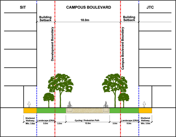
FIG 5: Typical section of the Campus Boulevard
The Campus Boulevard is envisaged to be a well-shaded and vibrant pedestrian mall flanked by the SIT Development and JTC Development providing a focal point for social interaction and collaboration between education, research and industry.
The Campus Boulevard as a public space shall be lushly landscaped for shade but with porosity at grade. It shall be designed as informal break-out spaces interfacing the adjacent developments, with seating for all users. The detailed design shall be subjected to further evaluation by relevant authorities.
The Campus Boulevard shall respond to and take advantage of the natural terrain, and be guided by the following datum levels as shown in the UD Guide Plans:
(a) RL 115 where it meets Sentul Crescent Extension at grade
(b) RL 115 where it meets the Heritage Trail at grade
(c) RL 115 where it crosses over the New Punggol Road
(d) RL 103.5 where it meets the waterfront promenade.
The Campus Boulevard shall provide for barrier-free accessibility throughout the length of the Boulevard and be integrated seamlessly with the adjacent developments at the respective levels. Any level differences are to be mitigated by ramps, which shall not exceed a slope rise of 1:25 along the length of the Boulevard.
Boulevard Extension
Part of Punggol Seventeenth Avenue, which branches off from the existing Punggol Road westwards (towards the landed housing cluster) is to be expunged and pedestrianised.
A minimum 15m wide pedestrian mall (Boulevard Extension) is to be provided, as an extension of the Campus Boulevard. This Boulevard Extension shall connect through the landed housing area, and onwards to the waterfront at the Northshore District.
The existing roadside Rain Trees shall be retained so as to provide a well-shaded pedestrian mall with seating for all users from the neighbourhood to enjoy.
Connection between Punggol Digital District to Punggol Town Centre
To facilitate the North-South pedestrian connectivity, a roadside cycling cum pedestrian path will be provided along Sentul Crescent Extension from the Campus Boulevard to the Punggol Town Centre.
Connection from Teck Lee LRT to the Waterfront
A minimum 3.6m wide covered walkway shall be provided for seamless connectivity from Teck Lee LRT to the waterfront across the Punggol Digital District. This shall be seamlessly connected to the Campus Boulevard and guided by the following datum levels as shown in the UD Guide Plan;
(a) RL 122 where it meets Teck Lee LRT station concourse
(b) RL 116-117 where it meets the Heritage Trail at grade
(c) RL 115 where it crosses over the New Punggol Road, Punggol Coast Road and Punggol Close
(d) RL 103.5 where it meets the waterfront promenade.
The walkway shall provide for barrier-free accessibility throughout its length and be integrated seamlessly with the adjacent developments at the respective levels. Any level differences are to be mitigated by ramps.
Covered Walkways/ Linkways
An all-weather pedestrian network, in the form of covered walkways, linkways and / or canopies shall be provided along the key pedestrian routes as shown indicatively in the UD Guide Plan. This shall take advantage of the existing terrain and the all-weather pedestrian connectivity shall be provided at 2 main datum levels:
(a) New Punggol Road/Bus Interchange level (RL 106-109)
(i) Along New Punggol Road, Punggol Coast Road, Punggol Close and Punggol Way
(b) Campus Boulevard / Elevated Pedestrian Network level (RL 115-122)
(i) Along Campus Boulevard
(ii) Along the key pedestrian route between Teck Lee LRT station and the waterfront
(iii) Along part of New Punggol Road, connecting Campus Boulevard to the key pedestrian route leading to Teck Lee LRT and the Creative Cluster.
The covered walkways/ linkways shall be at least 3.6m wide. The covered walkway shall be kept free from steps (wherever possible) throughout the entire length. Any level changes are to be accommodated by ramps. The covered walkway shall be kept free of structures and remain unobstructed and accessible to the public at all times.
Through-block Pedestrian Link
A minimum 6m and maximum 7m wide sheltered through-block link shall be provided at the following locations:
(a) At RL 107 from the bus stop along New Punggol Road to the waterfront promenade at RL 102.5
(b) At RL 109 between the Nexus and SIT’s entrance node
(c) At RL 109 to 110 between the Nexus and Bus Interchange.
These through-block pedestrian links within the developments shall be kept free, unobstructed and accessible for public use at all times. These links shall be at a constant level throughout the entire length. Any level changes are to be accommodated by ramps.
Elevated Pedestrian Linkway (EPL)
A minimum 3.6m wide EPL shall be provided at the following locations as shown indicatively in the UD Guide Plans, to complete the sheltered pedestrian network at the Campus Boulevard level:
(a) Across Sentul Crescent Extension to Teck Lee LRT at RL 122
(b) Across New Punggol Road at RL 115
(c) Across New Road A at RL 115
(d) Across New Road B at RL 115
(e) Across Punggol Way to facilitate public connectivity to the developments north of the Punggol Digital District at RL 115.
These EPLs shall be sheltered and be connected directly to the sheltered pedestrian network within the developments, as well as to the bus stops along New Punggol Road and Punggol Coast Road.
The detailed design of the EPLs shall be subject to the approval of relevant authorities.
Underground Pedestrian Links (UPLs)
An underground pedestrian link shall be provided at RL 97.95 under New Punggol Road to provide seamless connectivity between the MRT station / transport hub to the waterfront parcels across the road as indicatively shown in the UD Guide Plan.
This link shall be at least 6m wide if shops are provided on one side of the link, and 7m wide if shops are provided on both sides of the links, with a clear height of at least 4m.
Ground Level Porosity
A high degree of ground-level porosity is to be maintained so as to improve wind flows and views, as well as convenient public access through the precinct.
The required amount of ground-level porosity shall be computed based on porous area over total site area. Areas with a minimum of 6m clear ceiling height measured from the proposed building platform levels are considered porous. The clear heights of the voids shall be varied, where possible, so as to create a diverse and defined outdoor space.
There shall not be any physical enclosure or boundary walls around the site as the development ground-level open spaces/identified pedestrian thoroughfares shall be publicly accessible.
Public Spaces
Campus Heart along Heritage Trail
A minimum 1.8 hectare public community park (excluding Heritage Trail) (Campus Heart) is to be provided at the location indicated. The Campus Heart is envisaged to be an attractive communal and academic nucleus of Punggol Digital District.
The setting of this Campus Heart shall be informal and inviting for public to enjoy. It shall comprise of multiple scales of spaces and differentiated activities for students, industry engagements and community outreach. It shall be lushly landscaped with existing and new forest trees.
The Campus Heart shall be open and unobstructed to allow for easy pedestrian access and be highly visible from the adjoining street or pedestrian thoroughfare. The access and circulation within the Campus Heart shall be barrier-free and comply with BCA’s universal design guidelines.
The design of the Campus Heart shall include ample shade and seating to create a delightful and usable public space.
The existing topography and mature vegetation with the Campus Heart shall be retained so as to reinforce the natural rustic charm of Punggol.
NEXUS - ‘Entrance Node’ to the Integrated Transport Hub
A public space (NEXUS) of minimum 4,000sqm at RL 109 shall be provided to accentuate the sense of place and arrival to the Integrated Transport Hub at CC1 (comprising the future MRT station and Bus Interchange) as indicatively shown in the UD Guide Plan.
To be designed as a public plaza or forecourt, considerations shall be given to how the NEXUS can be used for events and activities in relation to the design and programmatic uses of the developments surrounding the public space. It can take the form of multi-volume covered spaces to be used as public ‘city-rooms’ and atrium spaces.
The design of the NEXUS shall take into consideration visual links, physical connectivity, way-finding, activity-generating uses and weather protection (i.e. covered walkways, sheltered linkways, etc.) to create a vibrant and comfortable tropical urban space.
An attractive entrance/ courtyard to the NEXUS from SIT shall be provided within SIT Parcel B.
The design of the NEXUS shall comply with Design Guidelines for Privately Owned Public Spaces (POPS).
Public Spaces at the Waterfront
A public space (Promenade Plaza) of minimum 3,000sqm shall be provided at the termination of the Campus Boulevard so as to accentuate the sense of arrival at the waterfront, as well as to provide a signature waterfront location for the staging of various public/ community events.
The setting of this Promenade Plaza shall be informal and cater for the students, office workers and residents of Punggol to enjoy the Punggol waterfront view.
Existing Casuarina trees adjacent and within the plaza shall be retained wherever possible. The Promenade Plaza shall be well-shaded to encourage public use throughout the day. A variety of seating for different users, age groups and physical abilities shall be provided.
The Promenade Plaza shall be seamlessly connected to the adjacent Market Village and the waterfront promenade i.e. Park Connector Network (PCN) by mitigating level differences as it steps down towards the waterfront.
Boulevard Plaza
A public space (Boulevard Plaza) of minimum 1,000sqm shall be provided as a transitional node, confluence point and entry to the Campus Boulevard that receives commuters from Punggol South, residents of Northshore district/landed housing cluster and students from the future educational parcels. It shall feature existing or new trees to retain the character of Punggol Seventeenth Avenue (that will be expunged along this stretch).
For more information, please refer to the Update to the Design Guidelines for Privately Owned Public Spaces (POPS).
Activity-Generating Uses
To create vibrant precincts, as well as attractive and pedestrian-friendly streets, activity-generating uses (AGUs) such as retail, food and beverage, and other active uses are to be provided at the following locations:
Alongside Campus Boulevard, NEXUS, the Market Village along waterfront promenade; and
Alongside the through block links and underground pedestrian walkways of the developments.
Activity-generating uses and other public or shared spaces such as incubators spaces are also strongly encouraged along New Punggol Road, as well as along the main pedestrian network.
For more information on AGUs, please refer to the Development Control Handbook.
Infrastructure & Streetscape
The following section is to be read together with the following plans:
Cycling Connectivity
To facilitate cycling as a mode of transportation to major transport nodes and key amenities, the district shall provide a cyclist-friendly, well-connected network to and from the waterfront and MRT/LRT stations.
Dedicated Cycling Routes
Certain key roads within the Punggol Digital District will be earmarked as dedicated cycling routes (please refer to the Special Detailed Control Plan: Connectivity Plan). The alignment, width and design of the cycling routes and associated street furniture are to be coordinated with NPARKS, LTA, and URA.
Bicycle Parking
Developments within the Punggol Digital District shall be required to construct and provide bicycle parking to accommodate a minimum number of bicycle parking lots within the Land Parcel based on prevailing requirements set out by the relevant Competent Authority at the formal submission stage.
The design and layout of the bicycle parking facilities will be subject to the requirements and approval of the Authority and the relevant Competent Authorities at the formal submission stage.
Integration of RTS (Rapid Transit System) and Related Structures
JTC development CC1 and CC2 shall ensure seamless integration and connectivity between the future Punggol Coast MRT station and bus-interchange, as well as the surrounding JTC and SIT developments.
The public space NEXUS to be located within JTC development CC2, shall be designed to accentuate a sense of arrival and enable seamless interchange between transport nodes at all levels.
The main entrance to the future MRT station shall be designed as a signature visual marker that is highly visible and easily identifiable to provide a sense of orientation to pedestrians at all levels, as well as to accentuate the sense of arrival to and from the Integrated Transport Hub.
This shall be provided at both the NEXUS (RL 109) and Campus Boulevard level (RL 115) as shown in the UD Guide Plans.
Vertical Circulation
Vertical circulation, including a pair of two- way escalators, staircases, and two passenger lifts, shall be provided at convenient locations that are easily visible and directly accessible from the NEXUS to key pedestrian routes at various levels as indicatively shown in the UD Guide Plans:
(a) Campus Boulevard at RL 115
(b) Elevated pedestrian links (EPL) to the developments North of the Punggol Digital District at RL 115
(c) Bus Interchange at JTC development CC1 at RL 110
(d) MRT entrance below Heritage Trail at RL 109
(e) MRT entrance near New Punggol Road at RL 107.5
(f) MRT station concourse at RL 97.95.
The entrances, mechanical shafts and other related pop-up structures of the future MRT station shall be well-integrated with the building form and overall architectural treatment of the JTC development CC1 and CC2.
The detailed design and integration of the RTS with the NEXUS and JTC development shall be subjected to further evaluation by the Competent Authority at the detailed design stage.
Basement Levels /Subterranean Development
The developments around the future MRT station are encouraged to make use of the knock-out panel provisions to the MRT station concourse at level RL 97.95 and utilise the underground spaces around the MRT station.
The developments shall capitalise on the existing undulating terrain to introduce natural lighting and open courtyards to the subterranean spaces.
Integration of Services including Ventilation Building
All services such as ventilation buildings, mechanical shafts, cooling towers etc. shall be integrated within the design of the developments.
Services are to be located underground, wherever possible or be well-integrated with the building form and overall architectural treatment of the development.
Servicing, Vehicular Access and Car Parks
Punggol Digital District is envisioned to be a car-lite district which will be public transport-oriented, as well as pedestrian and cyclist friendly.
Developments are to consider up-front demand management measures, such as reductions in car parking provision, variable pricing for parking and restrictions on delivery vehicles. These demand management measures shall be subject to the evaluation and approval of the relevant authorities.
Car parking spaces shall be provided within the basement level(s) of the developments.
A fully interconnected basement across the various parcels shall enable hub parking and building servicing. Connection levels and locations under roads are subject to detailed coordination with the relevant Authorities.
Vehicular ingress and egress to the developments for servicing, car parking and / or passenger drop-offs / pickup points are to be taken from the roads as indicated in the UD Guide Plans.
All vehicular ingresses / egresses and external ramps to the car parking, passenger drop-off / pick-up points, taxi lay-bys, service areas and loading / unloading bays shall be located within the site boundary and be well-integrated with the overall architectural treatment and building form of the development and visually well-screened, subject to the approval of LTA, the Authority and the relevant Competent Authorities at the formal submission stage.
Service areas such as refuse bin centres, loading / unloading bays, the electric substation and meter compartment etc. shall be located within basement levels of the developments as much as possible.
A fully interconnected basement across the various parcels shall enable hub parking and building servicing. Connection levels and locations under roads are subject to detailed coordination with the relevant Authorities.
For more information, please refer to Screening of Mechanical and Electrical Services and Car Parks.
Creative Hoarding
Where required, developments shall provide Creative Hoarding at construction sites to enhance the streetscape and create a more attractive and vibrant environment. The hoarding may incorporate commissioned artworks, community-produced graphics, or vertical greenery such as creepers and green walls. Where vertical greenery cannot be accommodated, large-scale photographic decals of greenery may be used as an alternative.
Creative Hoarding shall be installed along the key frontages of the development, i.e. fronting main streets and pedestrian routes. A minimum of 75% of the required creative hoarding length shall be covered with artwork or greenery.
For more information, please refer to the Creative Hoarding Guide.