
Jurong Lake District
Jurong Lake District (JLD) is a key growth area located in the west of Singapore. The district is envisioned as the largest mixed-use business district outside the city centre, a model for urban sustainability and innovation, and a place to grow businesses, homes, and communities by Jurong Lake Gardens, our third national gardens.
Last updated 14 July 2026
These urban design guidelines aim to guide the physical development of the area to ensure that individual buildings contribute to, and strengthen the planning vision for the respective zones and create an attractive and pedestrian-friendly physical environment.
Innovative designs that do not fully conform to the guidelines or standard building typologies, but are able to achieve the planning objective relevant to the requirement can be considered, subject to URA’s evaluation of the detailed proposal.
Gazetted monuments and conserved buildings are subject to specific preservation and conservation guidelines respectively, which will take precedence over the guidelines below.
Planning and Urban Design Guide
The Planning and Urban Design Guide aims to communicate the desired outcomes of the planning and urban design objectives, and the principles behind the design requirements. It shall be read together with the relevant land sales requirements and conditions for specific sites and developments.
Download Jurong Lake District Planning and Urban Design Guide [PDF, 9.9 MB]
Broad Positioning & Land Use
The following section is to be read together with the following plans:
Jurong Lake District (JLD) is envisioned as the largest mixed-use business district outside the city centre to support decentralisation and enable sustainable growth.
JLD covers the Jurong Gateway, Jurong Lake Central, Jurong Lake Gardens and International Business Park precincts.
To sustain the development momentum in JLD, the vacant land south of Jurong East MRT interchange station, between Jurong Town Hall Road and Ayer Rajah Expressway, will be developed progressively over the next 20 to 30 years for a mix of offices, housing, retail, hotel, entertainment, and other complementary amenities, within a car-lite and park-like setting. To support new district developments and improve island-wide connectivity, new Jurong Region Line and Cross Island Line MRT stations will be built, with the new precinct seamlessly connected to existing commercial areas and Jurong East MRT Interchange through an extensive, multi-level pedestrian network.
The mixed-use district is anchored on two unique but complementary precincts: Jurong Gateway and Jurong Lake Central.
Jurong Gateway
Centered around Jurong East MRT interchange station, Jurong Gateway serves as the current commercial core and offers a mix of office, retail and other complementary uses.
Jurong Lake Central
The new Jurong Lake Central precinct will extend seamlessly from the current commercial core. The sites in the new precinct are zoned for White use to allow for greater planning flexibility and to encourage a greater mix of complementary uses – commercial, residential, hotel and entertainment. Notable developments include the Science Centre and Jurong Town Hall.
Building Form & Massing
The following section is to be read together with the following plans:
Building Form
The overall building form and massing of individual buildings is to consider how the building will be viewed, as well as impact views from major approaches, key open spaces and pedestrian malls.
The design of the building form and massing, together with the architectural treatment, is to consider the scale, form and architectural expression of the surrounding buildings, and be designed to create engaging and varied public spaces. Wall-like developments shall be avoided.
For developments with building form requirements, alternative configurations of greenery provision can be considered, subject to relevant agencies’ approval.
Jurong Lake Central
To create a porous, pedestrian-friendly and lushly landscaped ground level, developments in the new precinct shall be designed such that at least 20% of the site is open-to-sky at the ground level. Part of the open-to-sky areas is envisaged as ‘Courtyards’ that are designed as extensions of the surrounding streets, connected by open-to-sky streets, through-block links or pedestrian malls. These areas shall be accessible and open to the public at all times.
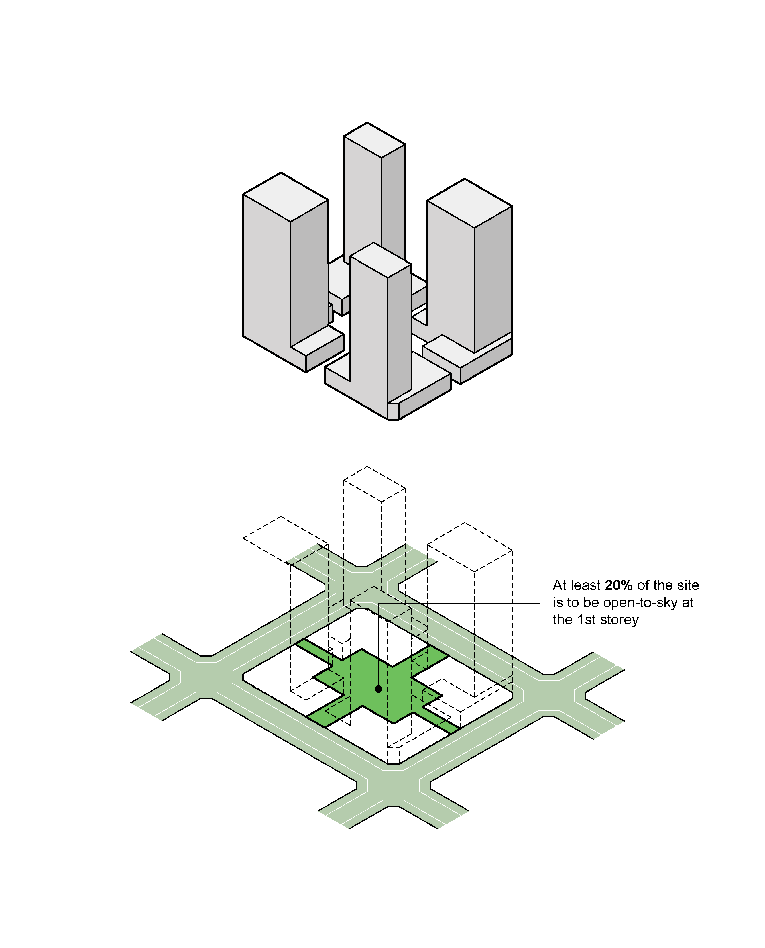
Fig.1: Courtyard typology with discrete, smaller scale building blocks, and highly porous ground level
The open-to-sky areas shall include meaningful and contiguous tree planting areas with a minimum area equivalent to 5% of the site area. These landscaped areas shall be designed to be publicly visible and accessible from the street.
Building Facades
The building facades of the development fronting all main roads and major public spaces are to be treated as main elevations. The building facades of the development are to be well-articulated with solid (walls) / void (fenestration) areas that draw upon a combination of different materials (e.g. concrete, brick, steel, glass, greenery, etc.)
To create visual interest and to further break down the building mass, elements of tropical architecture such as sky terraces, balconies, sun-shading louvers, deep recesses, window ledges, roof terraces, communal planter boxes and vertical green walls are to be provided as part of the development and integrated with the overall building form and architectural treatment of the development.
For more information, please refer to Sensitive Design and Development: An Industry Guide of Good Practices to minimize Wall-Like Development.
Building Height
Selected developments may be subject to site-specific building height controls, which are in response to site context and environmental conditions such as wind flow across the district. This will take precedence over technical height controls, whichever is lower.
Building Setback and Building Edge
Developments shall comply with the setback requirements in accordance with the prevailing Development Control guidelines. Selected developments may also be subject to site-specific setback controls, which will take precedence over prevailing DC guidelines.
Where applicable, developments are to be built up to the building setback line to create a well-defined urban streetscape. Up to 40% of the length of the building façade, between the corners of the development, can be set back for articulation of the building form.
Roofscape and Screening
The roof areas are to be considered as the “fifth” elevation and designed to complement the overall form, massing and architectural treatment of each development. The roofs can be designed to be usable outdoor spaces.
Screening Requirements
To ensure that the roof areas are well-designed and attractive when viewed from the surrounding developments, all service areas, mechanical and electrical (M&E) equipment, water tanks, etc., are to be located within and fully integrated into the building envelope and be visually well-screened from the top and all sides of the development.
For more information, please refer to Screening of Mechanical and Electrical Services and Car Parks.
Greenery Replacement and Landscaping
To create a green and sustainable city, all new developments will be required to incorporate landscaping in the form of sky terraces and roof gardens according to the Landscape Replacement Area (LRA) requirements.
For more information, please refer to the Development Control Handbook.
Jurong Lake Central
The vision for the precinct is to have a ‘green carpet’ effect at key levels to create a three-dimensional landscape datum (see Fig. 2). Prominent greenery shall be provided at the podium levels between the 2nd to 6th storey of the developments and shall include trees and shrubs planted close to the perimeter of the podium so that the greenery is visible from street level and adjacent developments.
These podium roof gardens are to be connected across the various building blocks within the development, to create a seamless experience of an additional green communal space above the street. Knock-out Panels shall be provided along the party wall for connection to future adjacent developments.
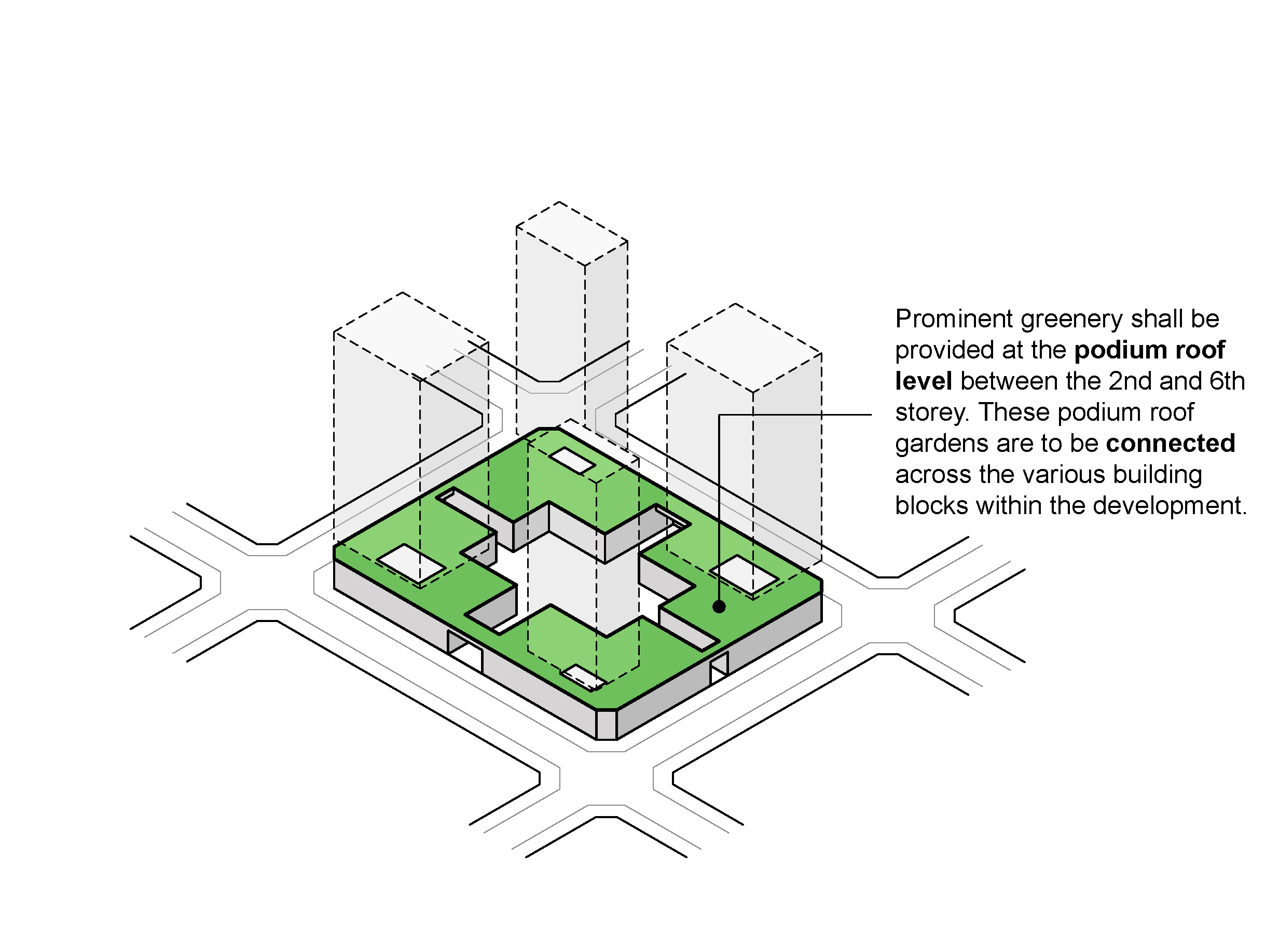
Fig. 2: ‘Green carpet ’effect through the provision of roof gardens at the podium levels
Connectivity & Active Uses
The following section is to be read together with the following plans:
Pedestrian Network
JLD is planned as a pedestrian-friendly area with a comprehensive sheltered network of pedestrian malls, covered walkways, 2nd storey links, and through-block links. This network provides convenient, comfortable, and seamless connections between developments, transport facilities, key spaces and attractions, and ensures all-weather comfort.
General Conditions
The pedestrian network on all levels is to be designed for universal access. GFA exemption is applicable for public spaces, covered walkways, through-block links and elevated walkways, subject to the prevailing Development Control Guidelines.
At-Grade Pedestrian Network
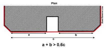
The at-grade pedestrian network is augmented by covered walkways that provide all-weather protected pedestrian routes. All developments are required to provide covered walkways at the 1st storey along the site boundaries / lines of Road Reserve or the designated building setback lines. The covered walkways function as public amenities. They are to be kept free of obstruction at all times.
The minimum width of the covered walkways is to be 3.6m or 5m. Where colonnades are provided, the internal clear width of the covered walkways is to be minimum 3.0m and 4.4m respectively. To provide adequate protection for pedestrians during inclement weather, the external soffit heights are to minimally match the width of the covered walkway.
To maintain a distinct precinct character, all covered and open walkways within the development boundary of developments bounded by Jurong East Pedestrian Mall (J-Link), Jurong East MRT station and Jurong East Street 12, are to be predominantly paved in mid to dark grey granite slabs of minimally 600 by 600 mm.
Through-Block Links
Selected developments are required to provide through-block links to break down the scale and improve permeability of the street block.
Elevated Pedestrian Network (EPN)
The EPN, also known as J-walk, is planned to provide seamless connectivity between developments and the existing Jurong East MRT interchange station. Building owners and developers are required to provide elevated links to connect between buildings.
The EPN is to match the finished floor level of the MRT station concourse (FFL 116.65) and be maintained at a constant level throughout its entire length, wherever possible.
The design and material specifications of floor finishes, handrails, signage, street furniture and lighting shall be subject to the approval of URA and the relevant Competent Authorities. Detailed design of the signage information displayed, shall also be subject to the approval of URA and the relevant Competent Authorities.
Vertical pedestrian circulation points are to be included within the building envelope to link the EPN to the covered walkways at the 1st storey. Each vertical circulation point is to include a pair of two-way escalators, staircases, and two passenger lifts. Unless otherwise specified, the entire EPN and the associated vertical circulation points are to remain open at all times and be visible from the at-grade and elevated pedestrian network.
Uses at the 1st and 2nd Storey Levels
To create vibrant precincts, as well as attractive and pedestrian-friendly streets, activity-generating uses (AGU) such as retail, food and beverage (F&B), and other active uses are to be provided at the following locations:
(a) The 1st storey of developments fronting pedestrian malls, key streets and public spaces; and
(b) Alongside the elevated pedestrian walkways at the 2nd storey of the developments.
For more information on AGUs, please refer to the Development Control Handbook.
Outdoor Refreshment Areas
Where allowed, Outdoor Refreshment Areas (ORA), i.e. outdoor dining areas, can be considered within the public areas or open spaces within private development sites. The scale and design of the ORA and its structures (if any) are to complement the adjacent building. They can only be considered as an extension of an adjoining indoor food and beverage (F&B) unit and are for seating only.
If provided, the Gross Floor Area (GFA) for the ORAs are to be computed as part of the maximum permissible GFA for the development and subject to the prevailing Development Control Guidelines under the Planning Act.
Developers are encouraged to incorporate spaces for ORAs at the design stage. The ORAs are to be clearly defined to prevent encroachment onto the adjacent pedestrian thoroughfares e.g. through the use of different floor finishes or planters, etc.
Public Space
It is important to provide public spaces within private developments for users to enjoy.
Selected developments are required to provide public spaces within the development site. These may be well-landscaped open spaces, or covered public spaces that provide a high degree of visual and physical porosity through the building.
Public spaces are to be publicly accessible at all times. They are to be connected to the key pedestrian routes at the 1st storey (such as open and covered walkways, through-block links, pedestrian malls and promenades), and, where applicable, designed to be well-integrated and easily accessible from the underground and elevated pedestrian networks within the development.
The design of these public spaces shall comply with the Design Guidelines for Privately Owned Public Spaces (POPS).
Infrastructure & Streetscape
Street Works within Road Reserve
To achieve a consistent district character, all new developments or those undergoing major additions and alterations are required to include the upgrading of the existing roadside tables within the adjacent Road Reserve, as specified below.
Open Walkway
As a guide, the open walkway within the Road Reserve is safeguarded for pedestrian use. Any proposed new paving with the Road Reserve will be subject to URA and LTA’s requirements and approval.
Tree and Shrub Planting Specifications
Any new tree or shrub planting specifications for the planting verge within the adjacent Road Reserves will be subject to URA and NParks’ requirements and approval.
Connection to Commuter Facilities
For developments with commuter facilities (e.g. bus stops and taxi stands) located in front of their buildings, sheltered linkways are to be provided between the covered walkways at the 1st storey to these facilities to provide direct continuous sheltered connections.
Dedicated Cycling Routes
Certain key roads within Jurong Gateway will be earmarked as dedicated cycling routes (please refer to the Special Detailed Control Plan: Connectivity Plan). The alignment, width and design of the cycling routes and associated street furniture are to be coordinated with URA and LTA.
Servicing, Vehicular Access and Car Parks
All driveways and vehicular accesses are to be located away from public spaces or main pedestrian routes. This is to create a seamless and pedestrian-friendly network that is uninterrupted by vehicles.
Jurong Lake Central
To create a car-lite environment and make the ground level pedestrian and cyclist-friendly, the car parking, pick-up / drop-off facilities and all service areas including those for the refuse bin centre, electrical substation, loading/unloading bays, holding bays, etc. are to be located at the basement levels.
The basement levels of all developments in the new precinct are to be interconnected to enable seamless movement of people, vehicles, deliveries, and other transport options that may arise in future (e.g., delivery robots, autonomous vehicles, etc.) between developments. Knock-out panels shall be provided along the common boundaries for connection to future basement levels of adjacent developments.
To maintain an attractive streetscape, any above-grade car park and service areas, including refuse bin centre(s), loading / unloading bays and vehicle ingress/ egress, storage lane(s), and vehicular drop-offs/ lay-bys, etc. are to be fully integrated within the overall building form, and visually well-screened from above and on all sides. Electrical substation(s), where required, can be located at-grade but are not to front onto the main roads, pedestrian malls, or public spaces.
Sufficient holding bays for the vehicular access points to the car parks and service areas are to be provided within the development to ensure the smooth flow of vehicles along adjacent roads.
For more information, please refer to the Screening of Mechanical and Electrical Services and Car Parks.
Night Lighting
Good night lighting can enhance the nightscape and district character. The night lighting scheme shall bring out the key architectural features of the building form, crown, facades, gardens and landscaped areas.
Signage
All developments shall comply with LTA’s signage and wayfinding requirements for Jurong Lake District,and submit the signage layout and design to the relevant Authorities for detailed evaluation and approval before Temporary Occupation Permit (TOP) can be issued.
Creative Hoarding
Where required, developments are to provide Creative Hoarding at construction sites to enhance the streetscape and create a more attractive and vibrant environment. The hoarding may incorporate commissioned artworks, community-produced graphics, or vertical greenery such as creepers and green walls. Where vertical greenery cannot be accommodated, large-scale photographic decals of greenery may be used as an alternative.
Creative Hoarding shall be installed along the key frontages of the development, i.e. fronting main streets and pedestrian routes. A minimum of 75% of the required creative hoarding length shall be covered with artwork or greenery.
For more information, please refer to the Creative Hoarding Guide.