
Reimagining Urban Mobility with Autonomous Vehicles
The road ahead: explore how AVs could transform the way we design, move, and live in our city.
Last updated 15 June 2026
An efficient and well-connected mobility system forms the backbone of a city, allowing access to a range of amenities and opportunities, and supporting social and economic activities. As mobility continues to evolve, Autonomous Vehicles (AVs) has emerged as yet another technological advancement that we could potentially harness, presenting many possibilities for transforming the way we live, work, play and move.
What are AVs?
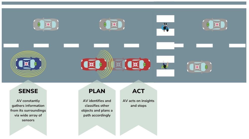
AVs are vehicles that can sense their environment and hence move with little or no human intervention. AVs sense their location and surroundings by gathering input from their suite of sensors. These sensors include cameras, Light Detection and Ranging (LiDAR), Radio Detection and Ranging (RADAR), Inertial Measurement Unit (IMU) and Global Navigation Satellite System (GNSS). They enable the AV to chart an efficient path towards its destination, while safely avoiding obstacles along its journey.
Benefits of AVs for our city
More space in our city
By optimising routing through intelligent algorithms and moving more efficiently, AVs may help to reduce traffic congestion and optimise road space by freeing up land for other uses. Hence, street space could potentially be reclaimed and re-designed for other uses, such as cycling lanes or greenery.
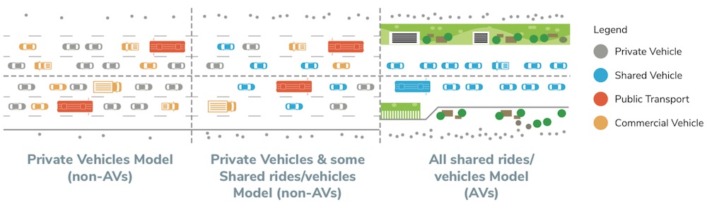
Carpooling in AVs that operate as taxis and private hire vehicles can reduce ‘zero passenger trips’ and the volume of traffic flow. Adapted from the San Francisco Municipal Transportation Agency.
Inclusive transport
AVs can potentially enhance the convenience and accessibility of first-and-last mile connectivity for persons with mobility challenges, such as seniors, through the provision of on-demand and dynamically routed autonomous bus and shuttle services.
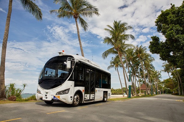
An on-demand 10-seater point-to-point shuttle in Sentosa. The AV was developed by Sentosa Development Corporation, ST Engineering and the Ministry of Transport. © ST Engineering
Safer roads
AVs have high fidelity sensors to sense their surroundings and navigate accurately in accordance with traffic conditions and rules, which can help to minimise accidents resulting from human error.
More optimised urban logistics
With increasing delivery volumes, AVs can serve to enhance business efficiency and improve customer convenience and experience by enabling contactless deliveries and supporting delivery and utility activities during off-peak hours.
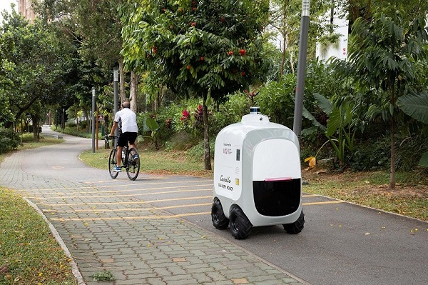
An autonomous mobile robot trials being conducted from March 2021 to February 2022 to deliver parcels and groceries from neighbourhood mall Oasis Terraces to residential blocks in Punggol Woodcress. © IMDA
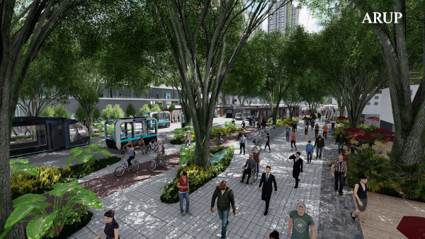
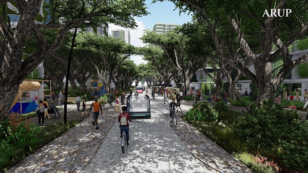
New possibilities for re-designing towns
People-centric streets and crossings
A future street layout should respond to the needs of users, prioritising walking, cycling and public transport, with AVs complementing these primary transport modes. Streets and crossings will ideally emphasise a people-first outcome instead of a traditional vehicle-first outcome.
Road network planning across Singapore has traditionally followed a hierarchical approach. A new classification system can be introduced for a more people-centric approach, where streets are tailored for different functions, modes, and speeds. For example, design and engineering firm Arup is exploring a ‘Movement and Place’ (M&P) framework for Singapore’s context.
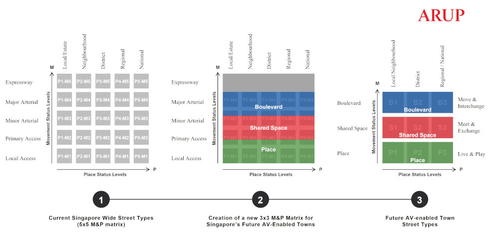
Various classifications under Arup’s M&P framework. The ‘Place’ axis (x-axis) represents the various land uses and user experience planned for the area while the ‘Movement’ axis (y-axis) is derived from the mix of transportation modes needed to move people and goods safely and efficiently.
Boulevard
In this framework, the ‘Boulevard’ is planned as a key movement corridor for public transport that will be connected by AV multi-purpose or community hubs.
Shared Space
The ‘Shared Space’ prioritises pedestrians and cyclists, a space that is set aside to connect them to the nearest bus-stop or train station. It is envisioned to be nearly car-free, with exceptions made only for emergency and service vehicles as well as the restricted use of last-mile slow-speed AVs for vulnerable users. Design interventions can also be put in place to minimise conflict among the different street users.
Place
‘Place’ is designated as people-only green corridors, which can form a network across town with public spaces for the local community to interact, rest and play across the town.
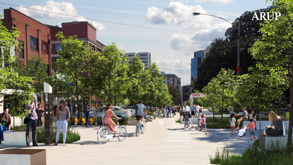
At the street level, there are two possible approaches to re-designing our streets when we welcome AVs – road segregation and shared streets.
In the former, specific lanes can be designated only for AVs. In the latter, shared streets can be constructed for AVs, cyclists and pedestrians, and designed to minimise conflict among the different street users. In the long term, transitioning to shared streets will reduce the space needed for multiple lanes and free up space for alternative uses, such as injecting more greenery into our urban environment.
![Thumbnail for Car-Centric versus People-Centric Design [Telok Ayer Street]](https://i.ytimg.com/vi/XBwhCVpeT3c/sddefault.jpg)
Simulation of Telok Ayer Street, comparing an existing car-centric design versus a more people-centric design. © CPG Consultants and PTV Group
Reducing parking spaces
Due to their automated and highly precise access and parking manoeuvres, AVs can park themselves closer to each other as compared to human-driven vehicles. This, together with the reduced need to allocate space for walkways and safety buffers that traditional parking would require, will make future car park layouts more space-efficient.
Additionally, parking space is likely to be further reduced if most AVs are fleet-owned and shared. Good urban design could enable AVs to be stored in a shared ‘hub’, located away from prime districts, instead of being parked and distributed in many buildings across the island. This would free up existing car park space for other amenities that could meet different needs and competing land use demands.
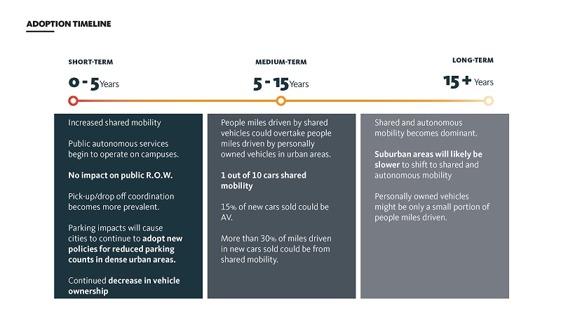
Gensler's vision of a possible AV adoption timeline. © Gensler
Pick-Up and Drop-Off points (PUDOs)
As AVs can either be parked automatically or routed to the nearest shared ‘hub’ for storage, traditional factors such as availability of parking or distance between car park and one’s destination will no longer be a concern in the future. Passengers or AV users would then place greater importance on the convenience of their origin and destination points. As such, PUDOs where users board and alight from the AVs may have to be redesigned to provide a more seamless and intuitive experience for passengers, and for the AVs to manoeuvre through smoothly.
New design ideas could be applied for the two types of PUDOs, on-street and off-street.
On-street PUDOs
AVs could increase the demand for on-street PUDOs. This in turn provides opportunities to rethink the use of road kerbs, in terms of how they can be designed and managed in a more flexible manner to accommodate different road users at different times of the day
Arup’s FlexKerb concept is one such example, where on-street PUDOs can operate on dedicated lanes or have dynamic kerbside management. Such ideas can reduce congestion at the PUDO and accommodate vehicles of different sizes while efficiently optimising space.
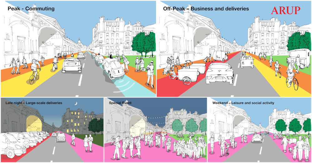
The Arup FlexKerb concept manages kerbside activity of the future. Kerbs could be transformed into dynamic, technologically sophisticated spaces that change function in response to user demand throughout the day. Even the most space-constrained streets are envisioned to accommodate a diversity of users. © Arup
Off-street PUDOs
Off-street PUDOs can reduce the risk of traffic congestions. They can be designed as a hub or co-located with other uses such as commercial developments to prevent them from turning into deserted and under-utilised spaces during off-peak hours.
In the future, PUDOs will no longer be just a place for commuters to board and alight but will also turn into lively community destinations with fully integrated public transport services and amenities to facilitate seamless journeys via AVs.
For example, global design firm Scott Brownrigg has developed a design for an integrated transport hub of the future, where buildings are repurposed to create a vibrant interactive environment co-occupied by AVs and people.
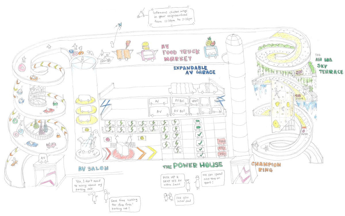
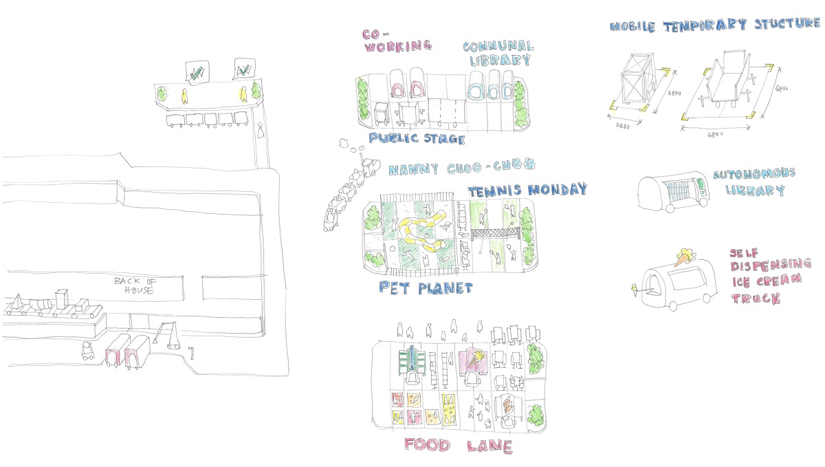
This includes implementing a vending machine-like system in former multi-storey car parks, which efficiently stacks, stores, charges, and cleans vehicles. This would free up space used as ramps and parking decks for social activities and improve user safety by separating vehicular and pedestrian routes. Neighbourhoods can also be transformed through the mobilisation of services facilitated by AVs, supporting various activities taking place across the city.