Urban Resilience
As climate change brings growing challenges to our city, Singapore is taking proactive steps to build urban resilience — from combating heat stress to protecting our coastlines from rising sea levels. Find out how we are planning ahead to create a more adaptable and sustainable city.
Last updated 25 June 2026
Building a climate-resilient city
Singapore must plan ahead to address the growing impact of climate change. Rising temperatures, more intense rainfall and rising sea levels can affect our liveability, infrastructure and daily lives.
To strengthen our urban resilience, we are developing long-term solutions to help Singapore stay cool, safe and sustainable – from designing more comfortable spaces to enhancing flood and coastal protection.
Ensuring urban thermal comfort
Rising temperatures pose a threat to our city’s liveability and increase the risk of heat stress. To strengthen Singapore's heat resilience, we work with researchers and industry partners to design and plan for a cooler city for current and future generations.
What is thermal comfort and heat stress?
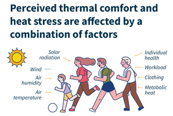
Thermal comfort refers to how warm or cold you feel in your surroundings and is influenced by environmental and physiological factors as well as clothing.
As temperatures rise, you may experience heat stress, which occurs when the human body is unable to cool itself sufficiently, leading to the buildup of excess heat. This can result in health risks such as heat exhaustion and heat stroke, especially in warm and humid conditions.
Improving outdoor thermal comfort
Analysing wind flow
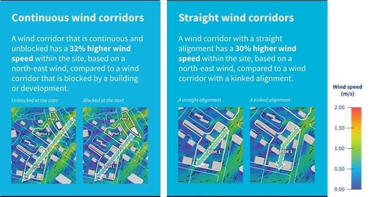
By leveraging environmental modelling at a district level, planners and architects can iterate and compare how different land use or design scenarios impact wind flow, including direction and speed.
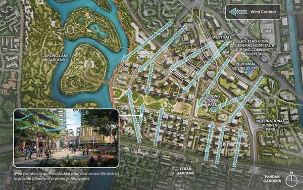
Wind corridors ensure unblocked wind flow across the district to provide cooler and breezier public spaces.
For example, wind flow analysis was conducted in the planning of Jurong Lake District to study how different road alignments, building configurations and widths of pedestrian walkways could influence wind speeds and thus, thermal comfort.
Providing more shade
Greenery provides multiple benefits, including shade and lower ambient temperature.
Parks and park connectors have been systematically planned islandwide to bring greenery closer to residents. Skyrise greenery, from rooftop gardens to façade plantings, have also been enhanced through URA’s Landscaping for Urban Spaces and High-Rises (LUSH) scheme.
Find out more about how we are planning for a City in Nature.
We are also exploring the use of data from the Walking & Cycling Network as well as 3D datasets of buildings and trees, to conduct shade analysis and identify suitable interventions, as illustrated below.
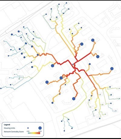
Step 1: Identify high usage pedestrian routes
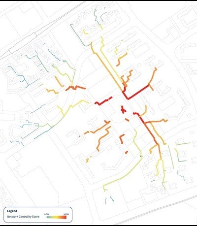
Step 2: Filter out sheltered routes
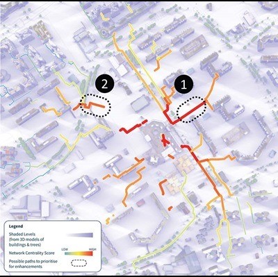
Step 3: Filter dataset further to identify routes that are unshaded by nearby buildings throughout the day
Step 4: Study possible interventions, such as additional planting to increase vegetation cover.
Improving the design of public spaces
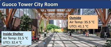
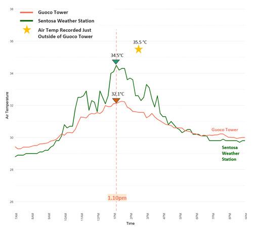
A study on Privately Owned Public Spaces (POPS) in Guoco Tower, Asia Square and Marina One provided insight into how design can moderate large temperature fluctuations and reduce heat stress.
UTCI stands for Universal Thermal Comfort Index, which is a measure for thermal comfort.
The study on Privately Owned Public Spaces (POPS) in Guoco Tower, Asia Square and Marina One provided insight into how design can play a part in moderating large temperature fluctuations and reducing heat stress.
Using the UTCI, the study found that the canopy at Guoco Tower Urban Park lowered temperatures by up to 2 degrees Celsius at noon. This was likely attributed to its overhead roof covering (canopy) and tall, open interior space (high volume), which together allowed air to circulate more freely and kept the space cooler for users.
This is complemented by a study from Gensler and Singapore-ETH Centre on POPS in Singapore, which showed that people are drawn to spaces that provide thermal comfort through shade and ventilation.
Design elements such as flooring materials, glass treatment, and urban furniture were also found to influence how comfortable people felt and how long they chose to stay in these spaces.
Strengthening flood resilience
By 2100, extreme daily rainfall is projected to increase across all seasons. Relative mean sea levels around Singapore could rise as much as 1.15 metres. Combined with storm surges and daily tidal activity, this could increase to between 4 and 5 metres.
As about 30 percent of Singapore’s land area is less than 5 metres above mean sea level today, our coastlines are vulnerable to flooding and there is a critical need to strengthen our flood resilience.
Coastal protection measures, when integrated with long-term development plans, could help manage both inland and coastal flooding risks while supporting future development needs.
Reimagine urban waterways
Many of Singapore’s concrete canals and ponds have adopted the Active, Beautiful, Clean (ABC Waters) Programme concept by integrating greenery into their design, creating attractive environments for both nature and people while supporting inland flood resilience.
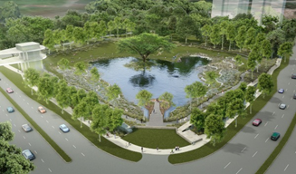
Alkaff Lake @ Bidadari Park. (Source: HDB)
Alkaff Lake is integrated within the new Bidadari Park as a stormwater retention pond that helps slow down and reduce stormwater runoff into the drainage system during a storm, thus reducing flood risks.
It is also designed with terrace wetlands and a cascading creek that help channel and cleanse stormwater runoff from the park before it discharges into Alkaff Lake. During dry weather, the banks of the lake and viewing decks serve as a communal space for the public to enjoy.
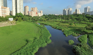
Kallang River @ Bishan-Ang Mo Kio Park. (Source: PUB)
The rejuvenation project of the Kallang River at Bishan-Ang Mo Kio Park not only increased the capacity of the waterway, but also created additional habitats for biodiversity.
The concrete canal was transformed into a naturalised river using a series of soil bioengineering techniques involving plants and natural material that help to stabilise the riverbanks. These features also create natural habitats that enrich biodiversity in the park and provide new recreational experiences for the public.
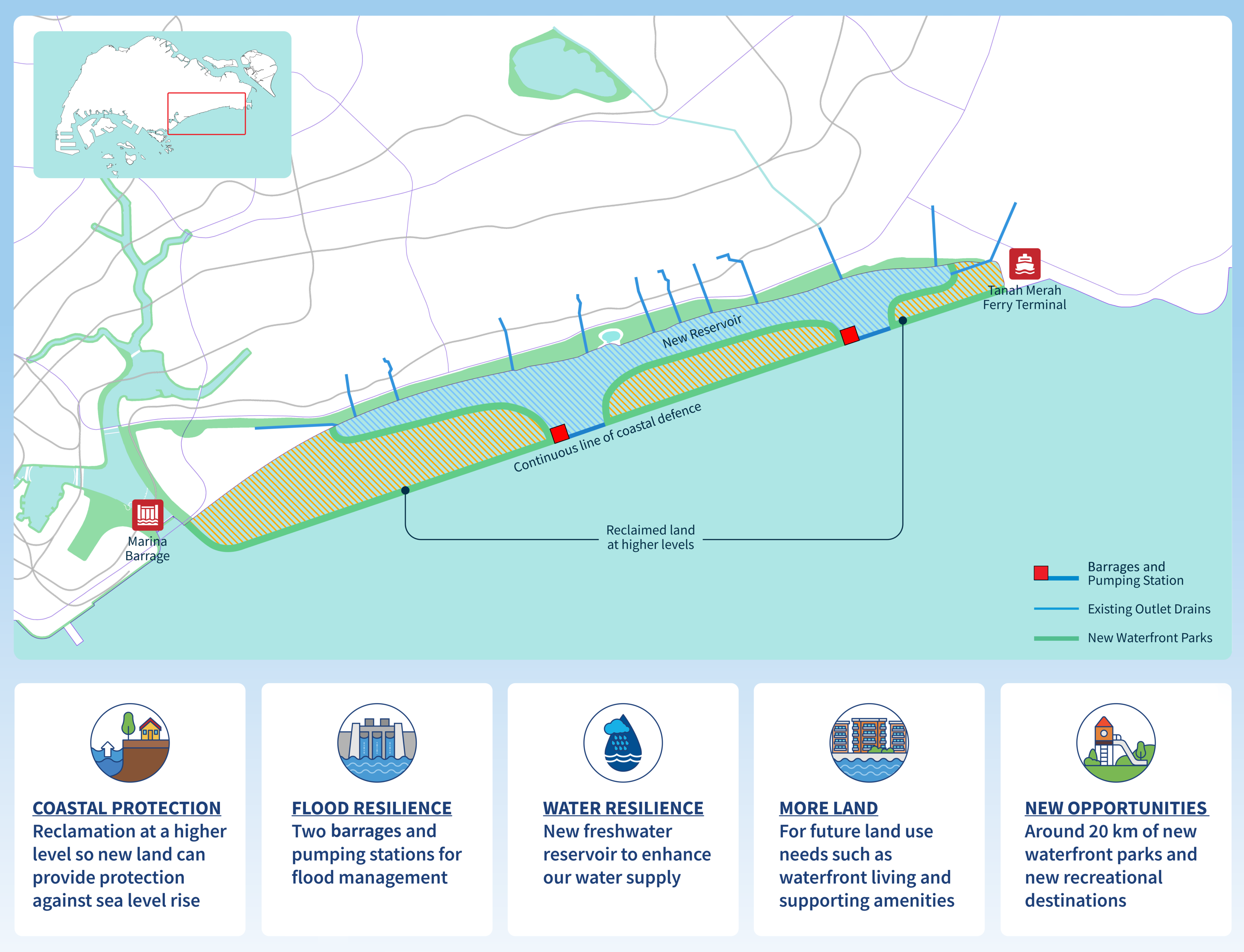
Shaping ‘Long Island’ together
When integrated with long-term planning, climate adaptation strategies will help to meet land use needs and provide opportunities to enhance Singapore’s urban environment.
First conceptualised in the 1991 Concept Plan, ‘Long Island’ is envisioned as an integrated solution that will address multiple national needs and announced at the National Day Rally in 2019 as such.
The project entails reclaiming about 800 hectares of land off the East Coast, to protect the low-lying area from sea level rise and strengthen Singapore’s flood resilience. It could also enhance Singapore’s water resilience with a new reservoir and create additional land to meet future development needs.
‘Long Island’ also presents new recreational opportunities by adding around 20 kilometres of new waterfront parks as part of a larger and continuous 120-kilometre-long stretch of accessible waterfront space along Singapore’s southern coast.