
A Comprehensive Mobility Network
Getting around Singapore will become more convenient and sustainable.
Last updated 25 May 2026
Facilitating sustainable mobility islandwide
Public transport and active mobility options will be the best way to move around the city.
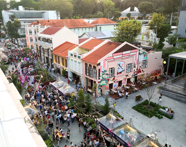
Public transport network
Our city will continue to focus on car-lite efforts by expanding our public transport network across the island.
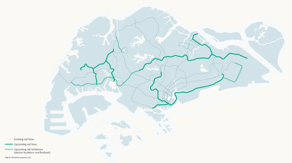
© LTA
Our MRT and bus networks will remain the backbone of our public transport system. We are on track to achieve our target of eight in 10 households within a 10-minute walk of a train station. We will continue to review our long-term transport demand and the infrastructure needed to support it, taking into consideration changes in travel patterns, such as more flexible working arrangements.
Transit Priority Corridors (TPC)
We will create an inclusive transport system that enables everyone to travel around conveniently and efficiently.
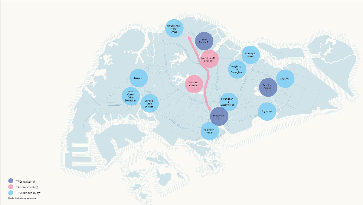
© LTA
Transit Priority Corridors consist of bus priority lanes together with wider footpaths, dedicated cycling paths or shared paths. We will add another 60km of these corridors by 2030, including the longest TPC - the North-South Corridor. As part of the long-term car-lite initiatives to move towards a more liveable and sustainable environment, more road spaces will be converted for buses, cyclists and pedestrians.
Walking and cycling across the island
Our transport system will be designed to better support more active mobility options that offer healthier and greener ways to travel.

© LTA
As more of us walk and cycle, we will expand our cycling network and supporting infrastructure across Singapore. Active mobility corridors, comprising cycling paths and park connectors, will offer interesting journeys for both leisure and commutes.
Creating active streets for all
More road spaces will be dedicated to public transport, active mobility and community uses. This can be done through repurposing existing ones for walking and cycling.
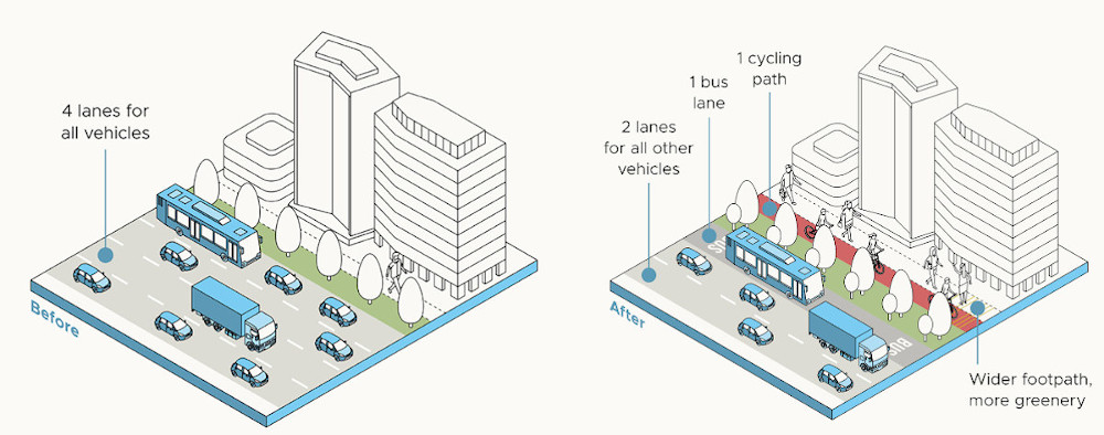
Across towns
Along major corridors between towns, dedicated spaces for buses, cycling and walking are planned to enhance the experience of public transport and active mobility. Barrier-free movement will be planned to help pedestrians and cyclists move around with ease. Stretches of the corridor close to amenities can be activated as areas of interest too.
The design considerations include:
Connecting community activities and identity nodes
Making the walk-cycle environment more pleasant with greenery
For example, the North-South Corridor offers dedicated spaces for different modes of travel — be it driving, riding, cycling or walking — as well as amenities along the way.
Within towns
Streets within towns will prioritise public buses and active mobility users, linking up residential areas with key transport nodes and amenities.
Within Neighbourhoods
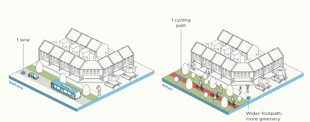
Road spaces have been repurposed into community spaces.
Streets within the neighbourhood will support safe and barrier-free walking and cycling. Those within car-free areas will also be lined with public spaces and rest stops.
Road spaces have been repurposed into community spaces.
Moving towards new futures
New technologies offer exciting opportunities to improve the way we move and the ways in which we get around the city continue to evolve.


These simulations depict the different flows in Singapore’s public transportation network with the entire employment population traveling to work (left) as compared to when 30% of them are working from home (right). © IHPC
For example, travel patterns will change with more flexible working arrangements. We will monitor movement patterns and simulate different possibilities to identify emerging trends and better plan for new needs.
We will look out for new transport innovations to explore their potential uses in Singapore.
Emerging transport technologies, particularly Autonomous Vehicles, can power more efficient travel and help realise our vision of car-lite towns.
Air taxis
Such vertical take-off and landing aircraft could allow quick trips within the city or across borders. A trip to Batam could take less than 20 minutes!
Taxis in the sky
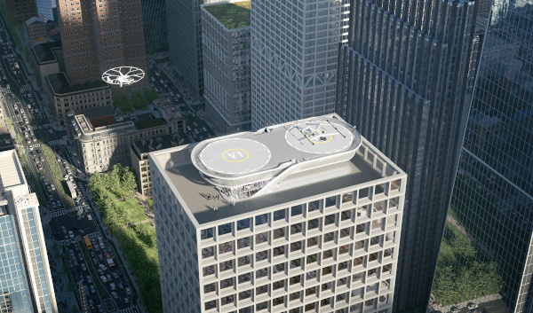
© Volocopter, Arup, Graft Architects and Bayards
ARUP, together with Volocopter, GRAFT Architects and Bayards Aluminium Constructions, have designed modular and easily scalable “vertiports” that can be placed in densely populated urban areas and small sites to support an urban air mobility network.
Unmanned aerial vehicles
Drones could make quick deliveries regardless of ground traffic conditions.
Mobility as a service
Various forms of transport and related services could be integrated into a single platform for users to plan, book and pay for their multi-modal travel needs within the city.
Autonomous Vehicles (AVs)
Not needing human intervention and smart enough to sense their environment, AVs can support the shift towards shared rides and transform the city:
Reclaiming of roads
The precision of AVs and sharing of vehicles will mean less space is needed for roads. Existing road space can be redesigned for walking, cycling and other activities instead.Storage, not parking
As AVs can park themselves, car parks do not need to have walkways and safety buffers for drivers, and instead can have more efficient layouts. AVs that are shared or owned as a fleet can even be stored in a hub away from prime districts. The reimagining of car parks frees up space for new uses.Pick up, drop off anywhere
Without the need to park their AVs, passengers and pedestrians can conveniently get on and off. Pick ups and drop offs can be redesigned to accommodate a more seamless journey.